
Westward Shift in 6Z Euro AI Storm Track Brings 4–8” Snow to DC–Baltimore Corridor and 6–10” From Boston to Cape Cod
NORTHEAST – The latest 6Z Euro AI run has shifted noticeably west compared to its previous cycle, placing a stronger swath of accumulating snow across the I-95 corridor from Washington and Baltimore northward into parts of New Jersey — while also increasing totals across southeastern New England.
At this stage, it’s too early to call this a miss. In fact, the westward adjustment puts several major metro areas back into meaningful snow potential.
Storm Track: Offshore but Closer to the Coast
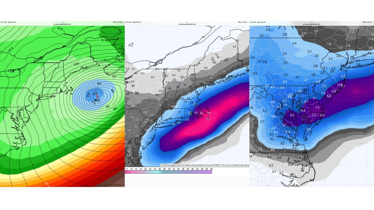
The pressure map shows a deepening low centered just offshore of the Mid-Atlantic coast, with tightly packed isobars indicating a strong system tracking northeastward. The 972 mb low sits east of the Delmarva and New Jersey coast — close enough to throw precipitation back inland but far enough offshore to keep the heaviest banding near the coast.
That westward jog is critical. A slightly farther east solution would confine heavier totals offshore. This run pulls the snow shield inland across key population centers.
DC–Baltimore to Southern New Jersey: 4–8 Inches Possible
Under the current depiction:
- Washington, DC and Baltimore appear in a 4–8 inch zone.
- Central Maryland and northern Delaware show similar totals.
- Southern and central New Jersey also fall within the moderate accumulation swath.
Snowfall amounts taper northwest of the urban corridor, with lighter totals into central Pennsylvania and western Maryland.
Boston, Providence, and Cape Cod: Higher-End Totals
Farther northeast, the model indicates a stronger deformation band developing as the system intensifies offshore.
- Boston and Providence are positioned for 6–10 inches.
- Southeast Massachusetts and Cape Cod show the highest totals in this run, with some offshore maxima exceeding 10 inches.
The gradient is sharp, meaning small track shifts could adjust totals meaningfully.
What Still Matters
While this run trends west:
- The storm remains offshore.
- Thermal profiles near the coast will need to support snow.
- Band placement will determine who ends up in heavier accumulation zones.
The difference between a 50-mile track shift can be the difference between 3 inches and 8 inches along the I-95 corridor.
Why It’s Too Early to Declare a Miss
Forecast confidence is still evolving. Ensemble spread and subsequent runs will determine whether:
- The westward shift holds.
- The low deepens at the same rate.
- Coastal mixing becomes an issue near the immediate shoreline.
Writing this off too early ignores the volatility typical of coastal winter systems at this lead time.
Bottom Line
The 6Z Euro AI run places:
- 4–8 inches from Washington and Baltimore north into parts of New Jersey
- 6–10 inches from Boston to Providence and southeast toward Cape Cod
This remains a track-sensitive system with meaningful potential along the Mid-Atlantic and New England coast. Further updates will clarify whether the westward trend continues or reverses.
For continued Mid-Atlantic and Northeast winter storm tracking, follow updates on WaldronNews.com.