
Widespread 4–8 Inches of Rain Target Plains, Midwest, Ohio Valley and Mid-South Through March 10, Drought Relief Coming but Flood Risk Increasing
UNITED STATES — A very active and wet weather pattern is setting up across the central and eastern United States over the next couple of weeks, bringing widespread drought relief to the Plains, Mid-South, Midwest, and Ohio Valley — but also raising the threat of flooding where heavy rain falls quickly.
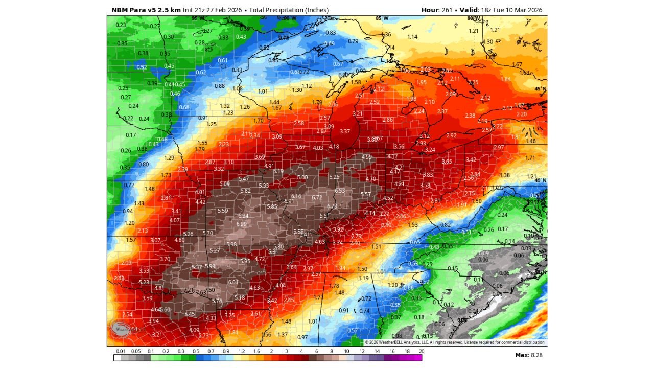
New precipitation projections through March 10 show an expansive swath of significant rainfall stretching from Texas and Oklahoma northeast into Missouri, Illinois, Indiana, Ohio, Michigan, and Kentucky.
Heaviest Totals Centered from Oklahoma to Illinois and Indiana
The highest rainfall amounts — shown in darker brown and red shading — are projected across:
- Central and eastern Oklahoma
- Much of Arkansas
- Southern and central Missouri
- Illinois and Indiana
- Western Kentucky and western Tennessee
- Portions of Iowa and Kansas
Many of these areas are forecast to receive 4 to 6 inches of rain, with localized pockets exceeding 6 to 8 inches.
Central Missouri, eastern Kansas, and parts of southern Illinois and Indiana appear to be in the core of the heaviest totals.
Expanding Rain Shield into the Midwest and Great Lakes
Rainfall extends northward into:
- Michigan
- Wisconsin
- Northern Illinois
- Northern Indiana
Totals here range from 2 to 4 inches, still substantial for early March.
Meanwhile, lighter but meaningful precipitation of 1 to 2 inches spreads into parts of:
- Ohio
- Pennsylvania
- Upstate New York
Lighter Totals Southeast and Far West
The Southeast — including Georgia, the Carolinas, and much of Florida — shows generally lighter totals, mostly under 1 inch in many spots.
Farther west, portions of:
- Colorado
- Wyoming
- Western Nebraska
- Western Kansas
are projected to receive lighter precipitation compared to the heavy axis farther east.
Drought Relief Likely Across Key Agricultural Zones
The central U.S. drought-stricken regions stand to benefit significantly.
Areas across:
- Kansas
- Oklahoma
- Missouri
- Arkansas
- Illinois
- Indiana
have experienced ongoing moisture deficits. Multi-inch rainfall events over a short time period could substantially recharge soils and improve water supply conditions heading into spring planting season.
Flooding Risk Increasing
While the rainfall is beneficial overall, the pattern is described as very active and persistent.
When multiple storm systems track over the same region in quick succession, rainfall can accumulate rapidly — especially over already saturated soils.
Flooding concerns would be highest in:
- Urban corridors
- River basins in the Midwest and Ohio Valley
- Low-lying areas in Arkansas and Missouri
- Portions of Illinois and Indiana where 5+ inch totals are projected
What Happens Next
The pattern suggests repeated storm systems riding along a favorable jet stream configuration, maintaining a steady feed of Gulf moisture into the central U.S.
If this setup persists as forecast:
- Drought conditions should improve across much of the Plains and Midwest.
- Rivers and streams may rise quickly.
- Some localized flooding issues could develop.
This is a classic early-spring transition pattern — one that trades dry winter conditions for a wetter, more active storm track.
Stay with WaldronNews.com as we monitor how much rain ultimately falls and track any developing flood concerns across the central United States.