
Winter Storm Continues Across Virginia, Maryland’s Eastern Shore, and North Carolina Overnight as Snow Tapers by Sunday Morning
VIRGINIA — A developing winter storm continues to impact parts of the Mid-Atlantic and Southeast tonight, with snowfall ongoing across portions of Virginia, the Lower Maryland Eastern Shore, and northeastern North Carolina before gradually tapering off by Sunday morning.
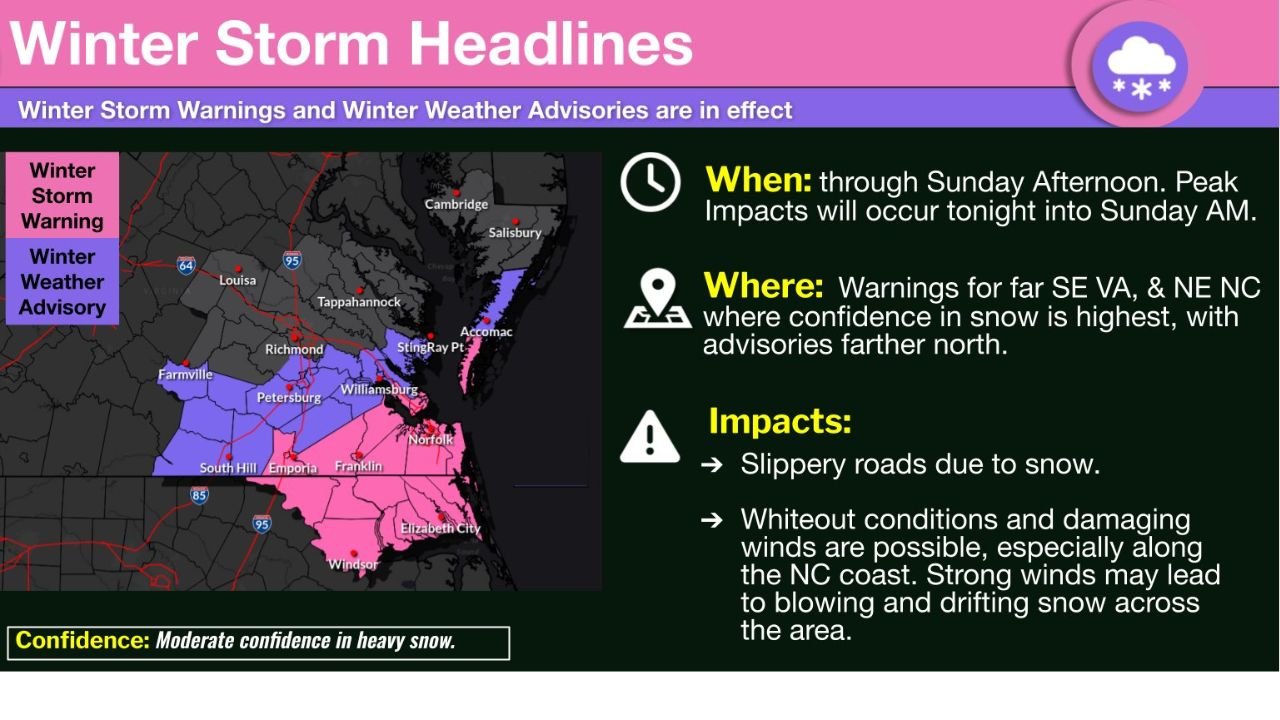
Updated guidance and real-time observations indicate that snowfall totals have trended lower than earlier projections across central Virginia and the Lower Maryland Eastern Shore, prompting forecasters to scale back Winter Weather Advisories in those areas. However, confidence remains higher for impactful snow farther south and east, where Winter Storm Warnings remain in effect.
Snow Continues Tonight Before Gradual Improvement Sunday
According to the National Weather Service office in Wakefield, Virginia, the storm will remain active overnight, with the peak impacts expected from late evening through early Sunday morning.
Snow intensity is forecast to diminish from northwest to southeast as the system pulls away, allowing conditions to slowly improve by Sunday afternoon. Despite this, slick and snow-covered roads will remain a concern, especially during the morning hours.
Highest Confidence for Heavy Snow in Southeast Virginia and Northeast North Carolina
Forecasters emphasize that the greatest confidence in accumulating snow remains across far southeastern Virginia and northeastern North Carolina, where Winter Storm Warnings are still in place.
Areas of concern include:
- Southeastern Virginia, including coastal and Tidewater communities
- Northeastern North Carolina, particularly locations closer to the coast
In these regions, snowfall rates may briefly intensify overnight, increasing the risk of hazardous travel and localized whiteout conditions.
Farther north — including central Virginia and parts of the Maryland Eastern Shore — snowfall totals have underperformed expectations, leading to advisory adjustments.
Wind and Visibility Impacts Along the Coast
In addition to snowfall, gusty winds developing near the coast could exacerbate conditions in warned areas.
Forecasters caution that:
- Blowing and drifting snow may reduce visibility
- Brief whiteout conditions are possible, especially near the North Carolina coast
- Strong winds could worsen travel impacts even where snow totals are moderate
These conditions are most likely overnight into early Sunday morning before easing later in the day.
Confidence Remains Moderate in Final Snow Totals
The Weather Service continues to express moderate confidence in the overall forecast, noting that while snowfall amounts have decreased in some locations, localized heavier bands remain possible, particularly near the coast.
Residents are urged to remain cautious, as even lighter snow can create dangerous driving conditions, especially on untreated roads and bridges.
What Residents Should Expect Next
By Sunday afternoon, snowfall is expected to wind down across the entire region, with lingering slick spots the primary concern. Temperatures will remain cold enough to prevent rapid melting, allowing icy patches to persist into Sunday night.
Officials recommend:
- Avoiding unnecessary travel overnight
- Slowing down and allowing extra braking distance
- Monitoring local advisories and road conditions
Did snowfall totals come in lower or higher than expected where you live? Share your experience and stay with WaldronNews for continued winter weather updates across the region.