
Winter Storm Signal Emerges for New York, New Jersey, Pennsylvania, Connecticut, Rhode Island, and Massachusetts as Coastal Setup Eyes Sunday–Monday Window
EAST COAST – A developing winter storm signal is beginning to show for late Sunday into Monday, with the latest ECMWF guidance highlighting a complex but potentially favorable setup for a coastal system impacting parts of the Mid-Atlantic and Northeast.
While this is not a locked-in forecast, the large-scale pattern is aligning in a way that warrants early attention — especially from New York City to Boston.
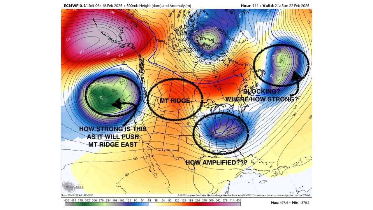
Key Player #1: West Coast “Bowling Ball” Energy
One of the most important features is a compact upper-level disturbance off the West Coast. This so-called “bowling ball” of energy will determine how the downstream ridge and trough pattern evolves across the central and eastern United States.
The strength of this western energy will dictate:
- How far east the Mountain West ridge shifts
- How sharply the eastern trough digs
- Whether energy consolidates closer to the East Coast
If that western feature pushes the ridge too far east, it could alter the timing and phasing potential downstream.
Key Player #2: Mountain Ridge Placement
The 500mb height map shows a pronounced ridge centered over the Rockies and High Plains. That ridge acts as a pivot point for downstream storm development.
A stronger ridge would:
- Amplify the eastern trough
- Promote deeper cyclogenesis along the coast
- Increase the odds of a more impactful Nor’easter
A weaker ridge could lead to a flatter, more progressive setup with limited coastal development.
Key Player #3: Quasi 50–50 Low and Blocking Near Atlantic Canada
Another critical piece is the upper-level low and potential blocking near Atlantic Canada. The placement and strength of this feature determine:
- How much room the coastal system has to tuck closer to shore
- Whether precipitation bands pivot inland or remain offshore
- How cold air is maintained over the Northeast
If blocking is strong enough and positioned favorably, it can help “bundle” energy along the East Coast rather than allowing the storm to escape east too quickly.
Tennessee Valley Vort Max Trending Stronger
The European model has trended stronger with a vorticity maximum dropping into the Tennessee Valley. That feature could act as the southern stream component in a potential phase with northern energy.
If the northern and southern jets phase at the right time, the setup resembles a classic Miller B-type system, which often favors:
- New York City
- Northern New Jersey
- Connecticut
- Rhode Island
- Eastern Massachusetts
These systems can bring a mix of snow, sleet, and rain depending on track and thermal structure.
Why This Is Still Early
Several moving parts must align:
- Western energy timing
- Ridge amplification
- Strength and location of Atlantic blocking
- Proper phasing of northern and southern jets
Even small adjustments in any of these elements could shift the storm track significantly.
Declaring this a major event now would be premature — but dismissing it entirely would also ignore a pattern that carries real upside potential.
Bottom Line
A winter storm signal is emerging for Sunday into Monday across portions of New York, New Jersey, Pennsylvania, Connecticut, Rhode Island, and Massachusetts. The setup features multiple embedded energy pieces, possible Atlantic blocking, and a strengthening Tennessee Valley disturbance — ingredients that could support a Miller B-type coastal system if timing aligns.
Confidence will increase over the next 24–48 hours as models refine the ridge-trough interaction and phasing potential.
For continued East Coast winter storm tracking and in-depth pattern analysis, stay with WaldronNews.com.