
Winter Storm Warning Issued for Connecticut and Massachusetts as Snow Brings Hazardous Travel Friday Night into Saturday
SOUTHERN NEW ENGLAND — A developing winter storm is expected to bring accumulating snow and dangerous travel conditions to parts of Connecticut and Massachusetts from Friday evening through Saturday morning, prompting Winter Storm Warnings and Winter Weather Advisories across the region.
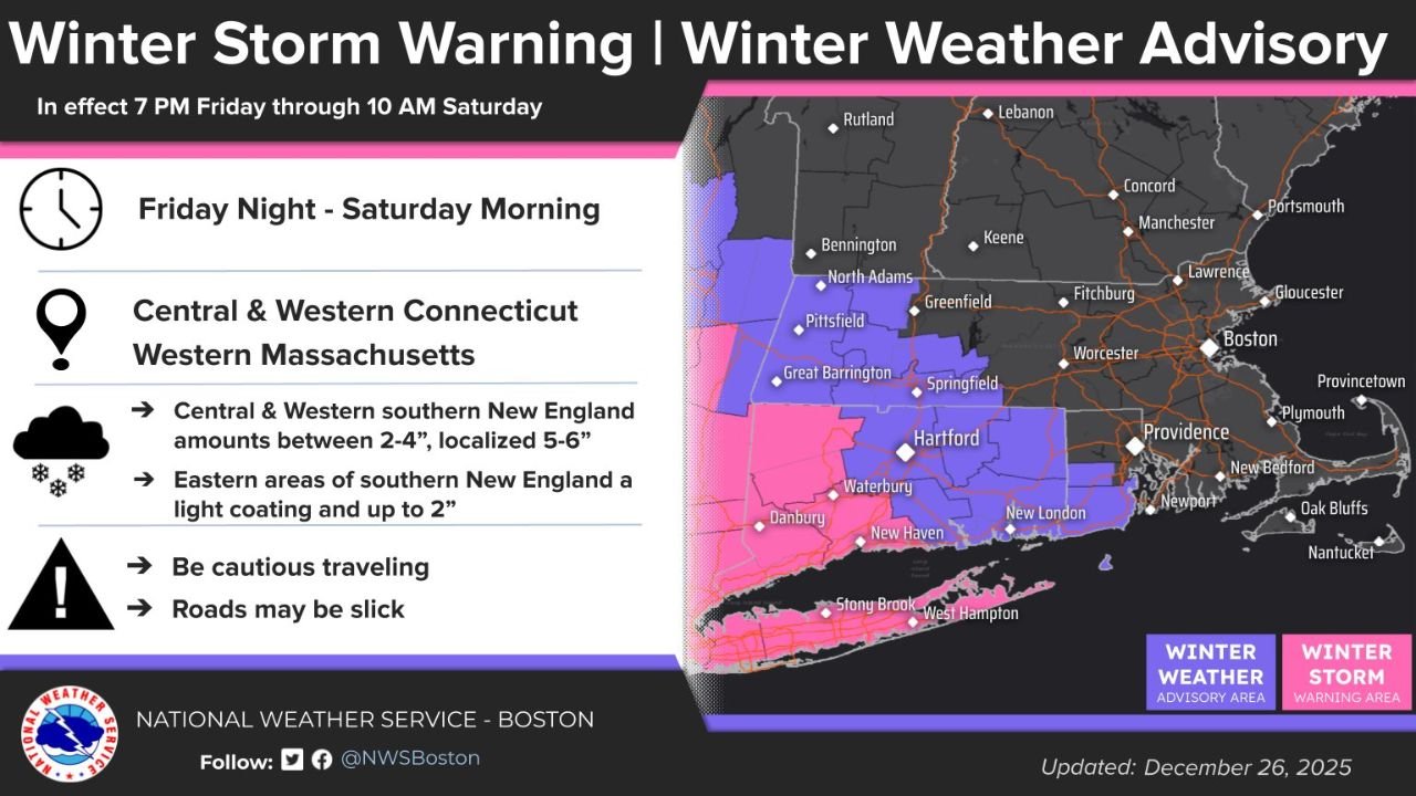
According to forecast data and alerts issued by the National Weather Service – NWS Boston/Norton, the most significant impacts will be felt across central and western Connecticut and western Massachusetts, where snowfall rates could briefly become heavy overnight.
Snowfall Totals and Most Impacted Areas
Forecast snowfall maps show a clear west-to-east gradient across southern New England.
- Central & Western Connecticut / Western Massachusetts:
Most locations are expected to receive 2 to 4 inches of snow, with localized totals of 5 to 6 inches possible in higher elevations and areas where snow bands persist longest. - Central Massachusetts and Interior Rhode Island:
Snowfall totals generally range between 1 and 3 inches, with localized higher amounts possible. - Eastern Massachusetts, Rhode Island Coast, and Cape Cod:
Snow amounts drop off significantly eastward, with many coastal areas seeing a light coating to up to 2 inches.
Cities such as Hartford, Springfield, Pittsfield, and Waterbury fall within the core accumulation zone, while Boston, Cape Cod, and the Islands are expected to see little to no measurable snowfall.
Winter Storm Warning and Advisory Details
A Winter Storm Warning is in effect from 7 PM Friday through 10 AM Saturday for portions of central and western Connecticut, where snow intensity and accumulation are expected to be highest.
Surrounding areas, including parts of western Massachusetts and interior Rhode Island, are under a Winter Weather Advisory, signaling lighter but still impactful snowfall.
Officials warn that road conditions may deteriorate rapidly overnight, especially on untreated roads, bridges, and elevated surfaces.
Timing: When Conditions Will Be Worst
- Snow begins: Friday evening, after sunset
- Heaviest snowfall: Late Friday night into early Saturday morning
- Tapering off: By mid-morning Saturday
Probability charts indicate the highest chance for snowfall rates exceeding 1 inch per hour between 9 PM and midnight in parts of western and central Connecticut, including areas near Bristol, Windsor Locks, and Springfield.
Travel and Safety Concerns
Transportation officials urge drivers to use extreme caution overnight and early Saturday, as snow-covered roads and reduced visibility could lead to accidents.
Key safety reminders include:
- Avoid unnecessary overnight travel if possible
- Allow extra stopping distance on slick roads
- Slow down and be alert for plow and treatment crews
- Prepare vehicles with winter emergency supplies
Even areas expecting lower snowfall totals could see slick conditions during the Friday night and early morning hours.
What Happens Next
Conditions are expected to gradually improve later Saturday as snow ends and road crews work to clear main routes. No major icing is anticipated, but cold temperatures could allow untreated surfaces to remain slippery into the morning commute.
Residents across Connecticut and Massachusetts are encouraged to monitor updated forecasts and local alerts as the storm progresses.
Stay with WaldronNews.com for continuing updates on winter weather, road conditions, and any additional advisories as this storm moves through the region.