
Winter Storm Watch Expands Across Carolinas and Southeast Virginia as Heavy Snow, Arctic Cold and Dangerous Travel Line Up This Weekend
NORTH CAROLINA — Forecast confidence continues to increase that a significant winter storm will impact much of the Carolinas, southeast Virginia, and parts of Tennessee from Friday afternoon through Saturday night, bringing widespread snowfall, sharply colder air, strong winds, and hazardous travel conditions across the region.
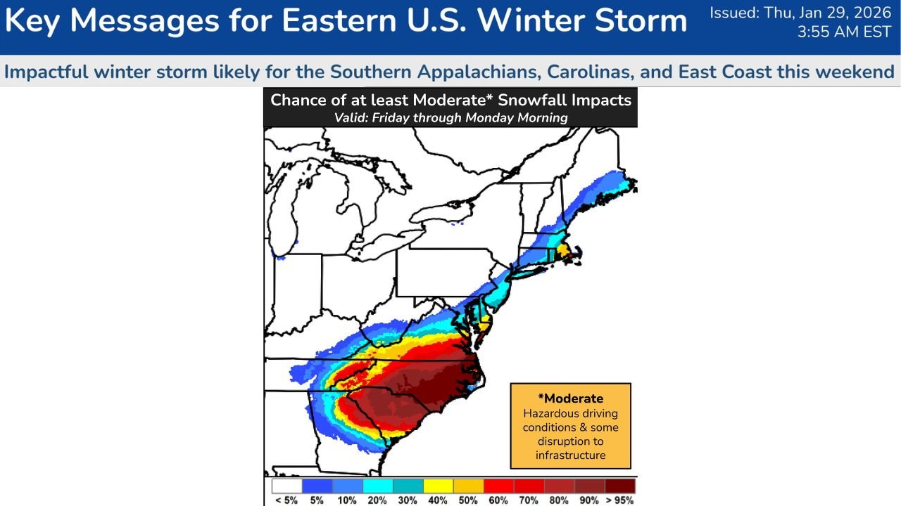
National Weather Service offices and the Weather Prediction Center now indicate a moderate to high probability of impactful snowfall, especially across the Southern Appalachians, central and eastern North Carolina, Upstate South Carolina, and southeast Virginia.
Winter Storm Watches Expand as Confidence Grows
A Winter Storm Watch has been issued for a large portion of the region, covering:
- Much of western and central North Carolina
- Upstate and northern South Carolina
- Southwest and southeast Virginia
- Portions of northeast and eastern Tennessee, including higher elevations
Forecasters warn that significant snowfall accumulations and difficult driving conditions are increasingly likely as the storm strengthens.
Snow Timing: When Conditions Will Deteriorate
Based on the latest data:
- Snow develops Friday afternoon, primarily east of Interstate 75
- Heaviest snowfall expected Friday night into Saturday
- Snow tapers late Saturday night, though impacts may linger into early Sunday
Travel conditions are expected to worsen rapidly during overnight Friday as snow intensity increases.
Snowfall Amounts: Heaviest Corridor Identified
Storm-total snowfall projections show a clear axis of heavier snow, with amounts varying by location:
- Central & eastern North Carolina (including Charlotte corridor): 6–8 inches possible
- Southwest Virginia & higher elevations: 4–6 inches
- Upstate South Carolina: 3–5 inches
- Northeast Tennessee & far east Tennessee mountains: 2–4 inches
- Western NC mountains: locally higher totals possible
Probability maps show 60–90% chances of exceeding 2 inches across much of the Carolinas and southeast Virginia.
Arctic Cold Already in Place, Making Impacts Worse
Ahead of the storm, a persistent Arctic air mass remains locked over the region:
- Temperatures running 10+ degrees below normal
- Patchy black ice possible during morning hours
- Wind chills dropping near zero, with 10–20 below zero at higher elevations
The cold air ensures precipitation falls primarily as snow, increasing accumulation potential.
Strong Winds and Coastal Impacts Also a Concern
As the storm rapidly intensifies:
- Strong onshore winds are expected along the Mid-Atlantic coast
- Near-blizzard conditions possible in northeast North Carolina and southeast Virginia
- Blowing snow may sharply reduce visibility
- Coastal flooding possible where winds align with high tides
Uncertainty Remains, but High-Impact Scenario Favored
While exact snowfall placement may still shift slightly, forecasters stress that the overall high-impact nature of this storm is becoming increasingly likely, especially for the Carolinas and southeast Virginia.
Even small changes in storm track could shift snowfall totals, but travel disruptions and dangerous cold are expected regardless.
What Residents Should Do Now
Residents across Virginia, North Carolina, South Carolina, and Tennessee should:
- Closely monitor forecast updates
- Prepare for hazardous travel Friday night and Saturday
- Limit unnecessary travel during peak snowfall
- Check cold-weather and emergency supplies
- Prepare for power disruptions in heavier snow zones
WaldronNews will continue tracking this developing winter storm with updated snowfall maps, timing changes, and state-by-state impact breakdowns as the event approaches.