
Winter Weather Advisory Issued for Oregon and Washington Cascades as Heavy Mountain Snow and Strong Winds Impact Pass Travel
PACIFIC NORTHWEST — A Winter Weather Advisory is in effect across portions of the Oregon and Washington Cascades as a new round of mountain snow moves into the region from early Friday morning through Saturday afternoon, creating hazardous travel conditions at higher elevations.
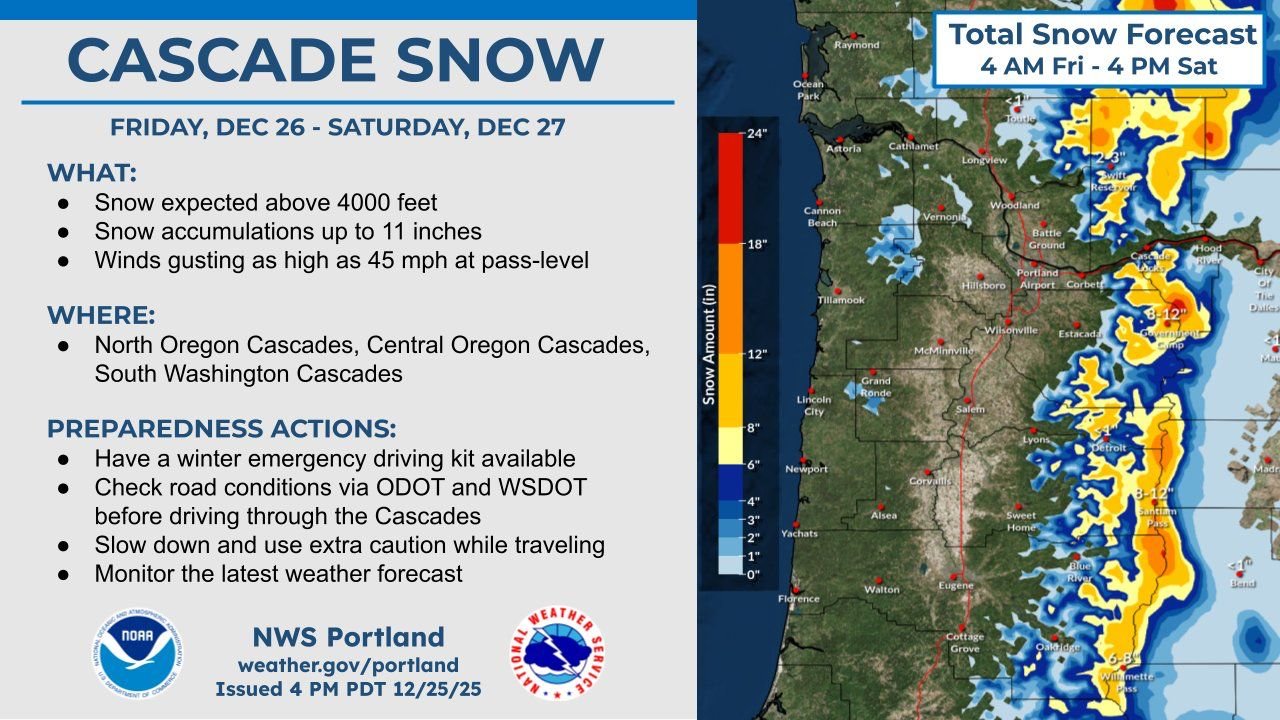
According to information released by the National Weather Service – NWS Portland, snow will primarily affect elevations above 4,000 feet, with the greatest impacts expected at Cascade mountain passes frequently used by holiday travelers.
Snowfall Forecast: How Much Is Expected
Forecast graphics show a prolonged period of snowfall along the Cascade crest, with totals increasing from north to south.
- Snow accumulations: Up to 11 inches in the higher Cascades
- Snow level: Mainly above 4,000 feet
- Highest totals: Along the Cascade crest in central Oregon and parts of south Washington
Lower elevations west of the Cascades, including the Willamette Valley and coastal communities, are expected to see little to no accumulation.
Strong Winds to Worsen Travel Conditions
In addition to snowfall, winds gusting up to 45 mph are expected at pass level. These strong winds may lead to:
- Blowing and drifting snow
- Rapid reductions in visibility
- Difficult driving conditions for high-profile vehicles
While whiteout conditions are not expected to be widespread, brief periods of sharply reduced visibility are possible during heavier snow bursts.
Areas Under the Winter Weather Advisory
The advisory covers:
- North Oregon Cascades
- Central Oregon Cascades
- South Washington Cascades
Popular travel corridors and mountain routes crossing the Cascades may be affected, especially during peak snowfall periods Friday night and early Saturday.
Timing: When Impacts Will Be Greatest
- Advisory begins: 4 AM Friday
- Most impactful period: Friday afternoon through Friday night
- Advisory ends: 4 PM Saturday
Snowfall rates may increase at times overnight Friday, particularly at higher elevations, before gradually tapering off Saturday afternoon.
Travel Advice and Preparedness
Weather officials urge travelers heading through the Cascades to take precautions:
- Check road conditions with ODOT and WSDOT before departure
- Carry a winter emergency driving kit
- Allow extra travel time
- Reduce speed and increase following distance
Even well-maintained mountain highways can become slick quickly during periods of steady snow.
What to Expect After the Advisory
Conditions are expected to slowly improve late Saturday as snowfall diminishes. However, lingering snow-packed roads and cold temperatures could continue to impact travel into Saturday evening.
Travelers and residents are encouraged to monitor updated forecasts and advisories as conditions evolve.
Stay with WaldronNews.com for continued coverage of Pacific Northwest weather impacts, travel alerts, and forecast updates as this winter system moves through the Cascades.