
Wisconsin Set for a Deep Freeze as December 19–January 1 Outlook Shows “Much Below Normal” Temperatures Across the Great Lakes Region
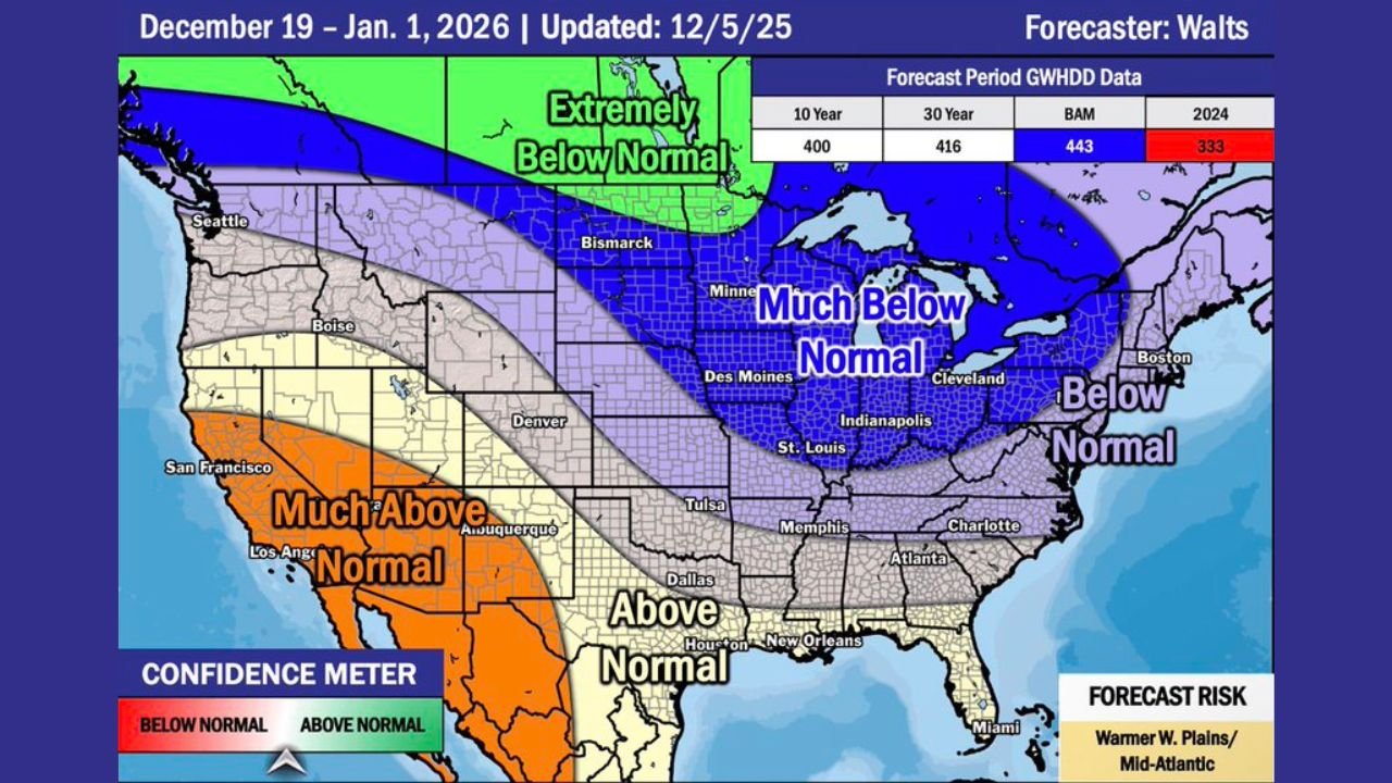
WISCONSIN — New long-range temperature guidance released this week points to a significantly colder end to December for Wisconsin, with the latest forecast showing a “Much Below Normal” temperature zone dominating the entire Great Lakes region between December 19 and January 1, 2026. Meteorologists warn that this incoming pattern may deliver extended Arctic air, increased heating demand, and the potential for more frequent snow events during the holiday period.
Great Lakes Region Falls Under a Strong Cold Signal
According to the updated outlook, a broad swath of deep blue shading — labeled Much Below Normal — stretches from the Dakotas through Minnesota, Wisconsin, Michigan, Illinois, Indiana and as far east as Ohio and western Pennsylvania.
Wisconsin sits directly in the core of this cold anomaly, with forecast confidence trending higher than average for late-December temperature departures.
Behind the scenes, climate model averages show that:
- Wisconsin could run 10–20°F colder than normal at times
- Cold air will likely be persistent, not brief
- The pattern may support increased winter storm activity depending on moisture availability
Forecaster Walts, who issued the update, notes that this temperature configuration aligns with broader hemispheric patterns favoring repeated cold intrusions into the central and eastern U.S.
Upper Midwest: “Extremely Below Normal” Cold Just to the Northwest
Another striking feature of the map is the band marked “Extremely Below Normal” stretching from Montana into the northern Plains. While Wisconsin is not inside that most severe zone, the proximity of such intense cold increases the likelihood that any shift in the storm track could bring additional Arctic air into the state.
Meteorologists say this northwest reservoir of frigid air often acts as a reinforcing supply, meaning Wisconsin could see multiple cold waves between Christmas and New Year’s.
Holiday Travel and Heating Demand Likely to Be Impacted
With temperatures projected to remain well below seasonal norms, Wisconsin residents should prepare for:
- Higher home-heating usage
- Potential lake-effect snow events near Lake Michigan and Lake Superior
- Hazardous travel during peak holiday traffic windows
- Increased risk of frozen pipes during overnight lows
This cold pattern may also elevate the likelihood of slick roads, especially during mornings when frigid air meets leftover moisture or light snowfall.
Sharp Temperature Divide Across the Country
While Wisconsin and the Great Lakes brace for deep winter conditions, the western United States faces a very different story. The forecast shows Much Above Normal temperatures across California, Nevada, Arizona, and parts of New Mexico.
This dramatic east-west contrast is a key indicator of a strong atmospheric boundary — one that could help fuel storm development, especially if moisture from the Gulf of Mexico becomes involved.
Why This Pattern Matters
Forecasters highlight that this late-December stretch is one of the most important periods for:
- Energy consumption forecasting
- Agricultural planning
- Holiday travel safety
- Winter-storm readiness
The map’s supporting data shows that the 2024 season (in red) is trending colder than the 10- and 30-year averages, reinforcing the expectation of widespread below-normal temperatures across Wisconsin and neighboring states.
Stay prepared for winter weather changes and follow WaldronNews.com for ongoing updates, statewide alerts, and detailed forecasts as the holiday cold pattern approaches.