
5 Day Severe Weather Outbreak Targets Over 50 Million Americans Across Texas, Oklahoma, Kansas, Missouri, Illinois and Michigan From April 11 Through April 15 With Hail and Tornadoes on the Table
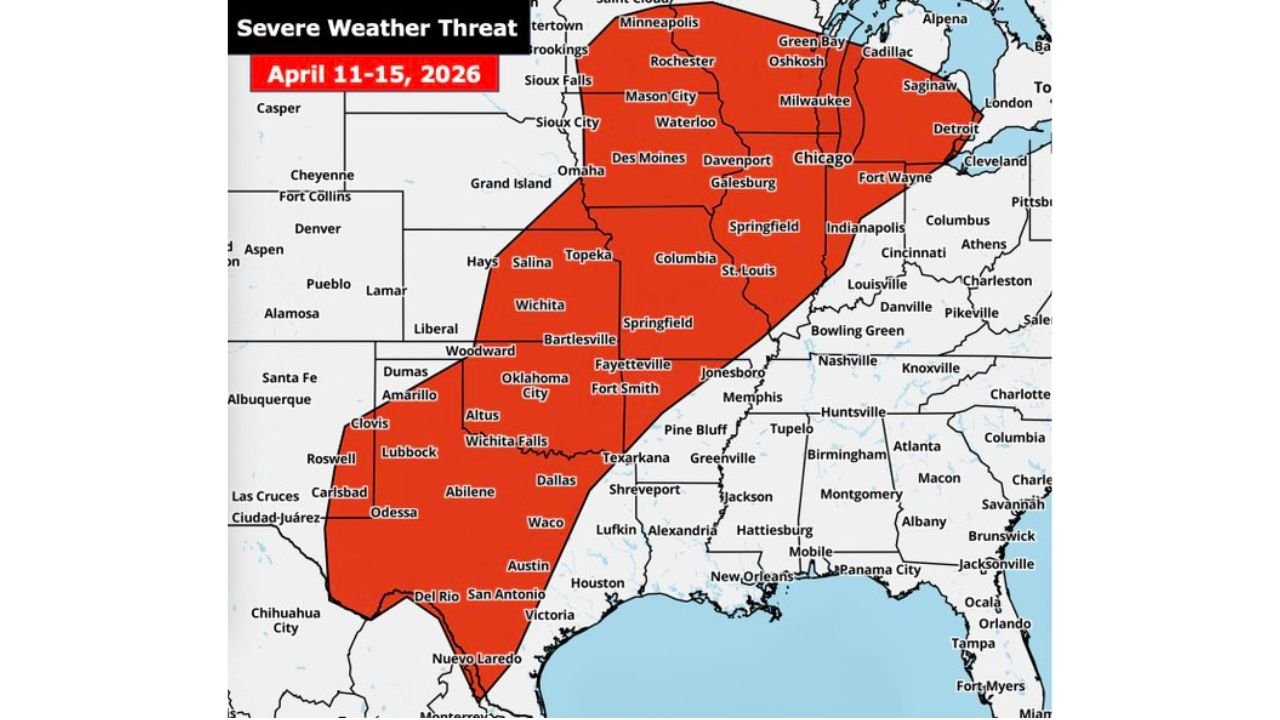
CHICAGO, Illinois — One of the most significant and wide-reaching severe weather outbreaks of 2026 is now officially underway, as a 5-day severe weather threat spanning April 11 through April 15 puts over 50 million Americans across the central United States directly in the path of dangerous storms capable of producing large hail, damaging winds, and tornadoes from the Texas Gulf Coast all the way north to Minneapolis and east through Chicago, Detroit, and Cleveland.
The threat is not a single event — it is a prolonged, multi-day atmospheric siege that delivers a separate and distinct severe weather corridor each day through the middle of next week, with hail the primary threat this weekend and tornadoes becoming increasingly possible Monday through Wednesday as the pattern evolves and the atmosphere reloads between rounds.
The Full Red Zone — Who Is at Risk April 11 Through 15
The severe weather threat zone covers an enormous swath of the central and southern United States. If you live anywhere in this area, this week demands your full attention:
- Texas: Amarillo, Lubbock, Abilene, Dallas, Waco, Austin, San Antonio, Houston, and the entire southern corridor including Del Rio and Victoria
- Oklahoma: Oklahoma City, Tulsa, Woodward, Altus, Bartlesville, and Wichita Falls
- Kansas: Wichita, Salina, Topeka, Hays, and Liberal
- Missouri: Kansas City, Columbia, St. Louis, and Springfield
- Arkansas: Fayetteville, Fort Smith, Jonesboro, and surrounding communities
- Illinois: Chicago, Springfield, and Galesburg sit inside the red zone
- Indiana: Fort Wayne and Indianapolis corridor
- Michigan: Detroit and surrounding southeast Michigan communities
- Minnesota: Minneapolis, Rochester, and Sioux Falls area
- Wisconsin: Milwaukee, Green Bay, and Oshkosh
- Iowa: Des Moines, Davenport, Waterloo, and Mason City
- Nebraska: Grand Island and Omaha
- Mississippi/Louisiana: Memphis, Shreveport, Jackson, and surrounding areas
Day by Day Breakdown — What Hits When
Saturday, April 11 — Kansas, Nebraska, Texas Panhandle: The outbreak opens Saturday with the storm threat focused across a corridor from the Texas Panhandle through Kansas and Nebraska — the cyan Saturday loop on the day-by-day map shows the initial severe weather boundary tracking through Amarillo, Lubbock, Liberal, Wichita, and Grand Island. Large hail is the dominant threat Saturday with tornadoes possible if discrete supercells can organize.
Sunday, April 12 — Kansas, Oklahoma, Texas: Sunday shifts the focus south and east with the green Sunday corridor targeting Wichita, Oklahoma City, Dallas, and San Antonio. This is a highly conditional setup where a strong atmospheric cap could suppress storms — but if storms break through, supercells capable of all severe hazards including tornadoes become the concern from central Kansas through the heart of Texas.
Monday, April 13 — Minnesota, Iowa, Illinois, Oklahoma, Texas: Monday brings a dual-threat setup with the pink Monday corridor splitting into two separate risk areas — one pushing through Minneapolis, Sioux Falls, Des Moines, and Chicago in the Upper Midwest, and a second arm threatening Oklahoma City and Dallas further south. Very large hail of 2 inches or greater is the primary Midwest concern while tornadoes remain on the table for the Southern Plains arm.
Tuesday, April 14 — Great Lakes, Ohio Valley, Illinois: Tuesday arrives as potentially the most atmospherically loaded day of the entire 5-day sequence. The red Tuesday corridor sweeps through Chicago, Fort Wayne, Indianapolis, Detroit, and Cleveland — with some of the highest instability values seen all year in place across this corridor. All severe hazards are on the table Tuesday including tornadoes, and the Great Lakes region will need to be on full alert.
Wednesday, April 15 — Tennessee Valley, Mid-South, Arkansas: The outbreak closes with Wednesday’s orange corridor targeting the Mid-South and Tennessee Valley — Memphis, Nashville, Huntsville, Fayetteville, Fort Smith, Jonesboro, and Knoxville all fall within Wednesday’s severe weather path. This final round could bring damaging winds, large hail, and tornadoes to communities that may already be dealing with storm fatigue from the previous four days of threats.
Why This 5-Day Outbreak Is Unusually Dangerous
What makes this severe weather sequence stand out is not just its geographic reach — it is the relentless, back-to-back nature of the threat. Most significant severe weather outbreaks last one or two days. A 5-day continuous severe weather siege affecting 50 million Americans across this many states is an extraordinary and rare meteorological event.
Each daily round arrives with a refreshed and reloaded atmosphere, meaning communities that dodge the worst of Saturday’s threat may face an equal or greater danger on Sunday, Monday, Tuesday, or Wednesday. The atmosphere does not get tired — and neither can the residents living within this red zone.
The finer details of each individual day’s tornado potential are still coming into focus, but the overall pattern is locked in and the threat is real across every state in the red zone through the middle of next week.
What Every Red Zone Resident Must Do This Week
- Identify your shelter location today — every home in the red zone should have a designated interior room on the lowest floor away from windows before this week begins
- Know which day specifically targets your community using the day-by-day breakdown above and treat that day as your highest alert day
- Have weather alerts active on multiple devices — phone, weather radio, and a trusted weather app all running simultaneously through the entire April 11-15 window
- Do not develop severe weather fatigue — each day brings a fresh threat and complacency between rounds is one of the most dangerous responses to a multi-day outbreak
- Residents across Texas, Oklahoma, Arkansas, and the Mid-South face threats on multiple days this week — assume every afternoon carries elevated risk until the pattern moves out after April 15
- Monitor NWS local forecast offices for your specific area daily — watches and warnings will be issued on short timelines and acting immediately when they are issued saves lives
Fifty million Americans are in this red zone. From San Antonio, Texas to Minneapolis, Minnesota to Detroit, Michigan — the atmosphere is cycling through one dangerous setup after another this week and every community in the red zone deserves to be weather-ready before each day’s threat window arrives.
WaldronNews.com will continue tracking this historic 5-day severe weather outbreak across Texas, Oklahoma, Kansas, Missouri, Illinois, Michigan, and the broader central United States and will provide daily updates as each round of storms approaches.