
55 mph Wind Gusts and Rapid Lightning Strike Denver, Boulder and Fort Collins as Severe Thunderstorms Expand Across Colorado Foothills and Into Southeast Wyoming
DENVER, Colorado — A fast-moving and dangerous storm system is sweeping across Colorado’s Front Range right now, as shower and thunderstorm activity rapidly expands across the foothills west of I-25 and stretches north into southeast Wyoming — bringing intense lightning strikes, wind gusts up to 55 mph, and deteriorating conditions that are already impacting air traffic into Denver International Airport.
The storm corridor is active and moving, with lightning activity ramping up significantly across Larimer County, Boulder County, and into Park County — putting communities from Fort Collins and Boulder south through Denver, Centennial, and Castle Rock all under an immediate and worsening weather threat.
Communities Directly in the Storm Path
- Colorado — Larimer County: Fort Collins and surrounding communities are seeing rapidly increasing lightning activity as storms expand east off the foothills
- Colorado — Boulder County: Boulder and Longmont are inside the active lightning corridor with storms intensifying across the county
- Colorado — Park County: Storm activity is pushing into Park County including Bailey and surrounding mountain communities
- Colorado — Denver Metro: Denver, Centennial, Castle Rock, Woodmoor, and Perry Park all sit within the active storm zone along and west of I-25
- Colorado — Southern Corridor: Colorado Springs, Lake George, and communities along the southern Front Range are within the expanding storm coverage area
- Wyoming — Southeast: Cheyenne, Laramie, Wheatland, and Torrington are all experiencing the northern reach of this storm system with 55 mph wind gusts already reported across the region
Active Threats Right Now
This is not an approaching storm — it is already happening across the Front Range, and conditions are deteriorating quickly:
- 55 mph wind gusts — Southeast Wyoming including Cheyenne and Laramie is already being hammered by wind gusts up to 55 mph. These are strong enough to down tree limbs, damage property, create dangerous driving conditions on I-25 and I-80, and make outdoor activities immediately hazardous
- Intense lightning activity — Lightning is ramping up rapidly across Larimer County, Boulder County, and Park County specifically. Anyone outdoors in Fort Collins, Boulder, or the surrounding foothills communities needs to get inside a sturdy building immediately — lightning from these storms is frequent and dangerous
- Aviation impacts at Denver — Inbound flights into Denver International Airport are currently circling in holding patterns, navigating around active storm cells and avoiding dangerous wind shear conditions. Travelers with flights into or out of Denver should expect significant delays and check their flight status immediately
- Expanding storm coverage — The storm activity is not staying stationary — it is actively expanding eastward across the foothills and pushing into the plains communities along and east of I-25, meaning communities that are currently on the edge of the storm are about to be directly inside it
Why the I-25 Corridor Needs to Act Now
The I-25 corridor from Fort Collins through Denver to Colorado Springs is one of the most heavily traveled highway corridors in the entire Rocky Mountain region — and it is sitting directly inside tonight’s most active storm zone. Wind gusts of 55 mph combined with intense lightning and rapidly expanding thunderstorm coverage create extremely dangerous driving conditions, particularly for high-profile vehicles, motorcycles, and anyone traveling through the mountain passes and foothills areas west of the interstate.
The storm system pushing through Larimer and Boulder Counties is also moving into an area where afternoon outdoor activity is common — hikers, cyclists, and residents in communities like Boulder, Longmont, and Fort Collins who may be caught outside need to immediately seek shelter. Lightning from these storms is not a distant threat — it is actively striking across the county right now.
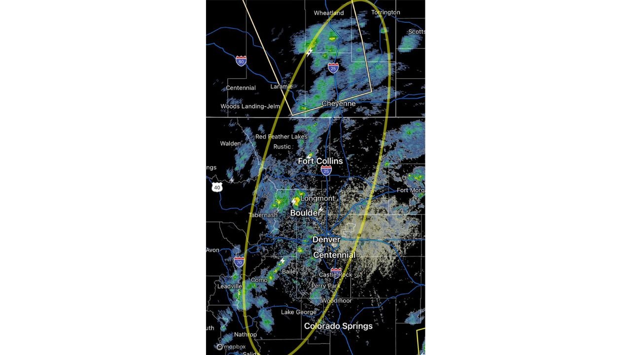
For Denver metro residents, the expanding storm coverage means conditions will continue to deteriorate through the early evening hours. The yellow oval visible on radar encompassing the entire Front Range from Cheyenne south to Colorado Springs shows just how wide and active this storm corridor has become.
What to Do Right Now
- If you are outdoors anywhere in Larimer County, Boulder County, Fort Collins, Boulder, or Denver — get inside a sturdy building immediately and stay away from windows
- I-25 drivers between Cheyenne and Colorado Springs should reduce speed, watch for sudden gusts, and be prepared for rapidly changing visibility in heavy rain and hail
- Denver International Airport travelers should check flight status now — holding patterns and rerouting are already underway and delays will compound through the evening
- Residents in Cheyenne and Laramie, Wyoming should secure any loose outdoor items immediately — 55 mph gusts are strong enough to turn unsecured objects into dangerous projectiles
- Do not seek shelter under trees, in open structures, or in vehicles during the most active lightning phase — move to a substantial building with four walls and a roof
- Monitor NWS Boulder and NWS Cheyenne for any severe thunderstorm warnings or tornado warnings that may be issued as storms continue to intensify
The storm is here, it is active, and it is expanding. Residents across the Colorado Front Range from Fort Collins to Colorado Springs and into southeast Wyoming are urged to take shelter immediately, stay off the roads if possible, and monitor conditions closely as this dangerous storm system continues to push through the region.
WaldronNews.com will continue tracking this active storm system across Colorado and Wyoming and will provide updates as conditions evolve through the evening.