
Florida Could Face Significant Cold Outbreak Next Week as Forecast Models Signal Widespread Freeze Potential
FLORIDA — A potentially significant cold air outbreak is being closely monitored for Florida next week, as multiple long-range forecast models indicate a strong push of Arctic air moving deep into the Southeast and into the Florida Peninsula by midweek.
While the event remains several days away and details may still change, both the ECMWF (European) and AI-driven GFS guidance are showing a consistent signal for much colder-than-normal temperatures across large portions of the state, raising concerns for freeze conditions well south of where they typically occur.
Early indications suggest this could be one of the more notable cold intrusions Florida has seen in recent years, particularly if the colder model solutions verify.
Cold Air Signal Strengthening in Long-Range Models
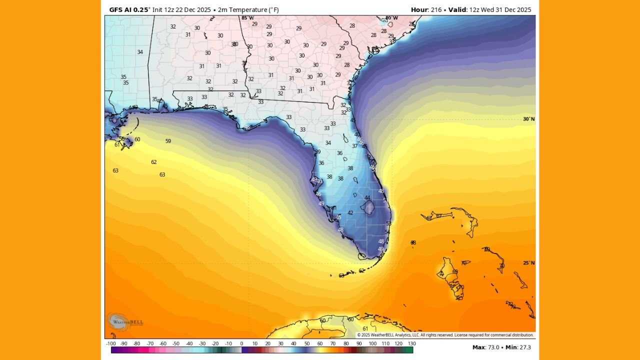
Forecast imagery shows a pronounced surge of cold air plunging southward through the eastern United States late next week, with temperature gradients tightening sharply across the Gulf Coast and Florida.
Both major global models depict surface temperatures dropping into the 30s across much of central Florida, with even colder readings possible across northern portions of the state. In some scenarios, freeze-level temperatures extend well into the interior Peninsula, an uncommon setup for late December.
Meteorologists caution that while confidence in exact temperatures is still limited at this range, the overall pattern strongly favors a legitimate cold event rather than a glancing cool down.
Freeze Potential Extending Deep Into the Peninsula
If the colder solutions materialize, freeze warnings could eventually be required across areas that rarely experience sub-freezing conditions, including parts of central Florida. Coastal locations would remain somewhat moderated by surrounding waters, but inland areas could see more pronounced impacts.
This type of setup raises concerns for:
- Sensitive vegetation and agriculture
- Outdoor plumbing and exposed pipes
- Homeless and vulnerable populations
- Extended overnight cold stress due to longer winter nights
The model imagery shows Florida fully embedded beneath a broad cold air mass, rather than sitting on the fringe — a key detail that increases the seriousness of the setup.
Timing and Uncertainty Still Remain
Forecasters emphasize that this system is still about a week away, meaning exact timing, temperature lows, and geographic extent could shift as newer data becomes available.
However, the fact that multiple independent models are consistently showing a strong cold signal at this range increases confidence that some form of impactful cold weather is likely.
Residents are encouraged to stay informed as forecast confidence improves over the coming days.
What Residents Should Watch For
As the situation evolves, Floridians should monitor:
- Updates on potential Freeze Watches or Warnings
- Overnight low temperature forecasts
- Cold duration, not just minimum temperatures
- Local advisories for agriculture and outdoor safety
This cold pattern bears watching closely and could become a notable weather event for the state as December comes to an end.
WaldronNews.com will continue tracking forecast updates and provide timely coverage as new information becomes available.