
Oklahoma and Kansas Face Classic Dryline Supercells Sunday With Very High Ceiling as Storms Could Explode Into Dangerous Twisters Within Minutes
OKLAHOMA CITY, Oklahoma — Sunday’s severe weather setup is being called a classic Plains dryline event — and forecasters are warning it has a very high ceiling, meaning the potential for truly violent storms is not being capped by any limiting factors in the atmosphere. Once storms fire along the dryline cutting through Oklahoma and Kansas, they could rapidly explode into intense supercells capable of producing significant severe weather — and the danger can develop very quickly.
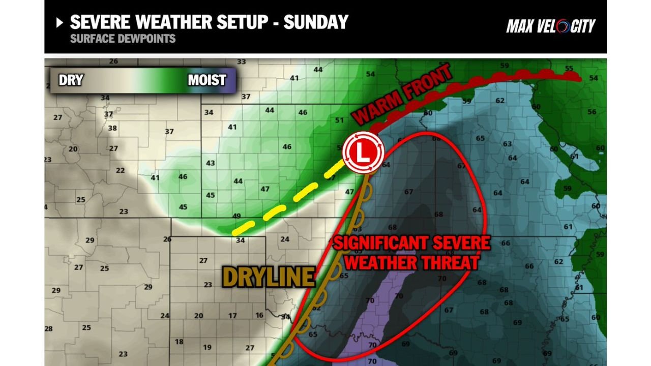
The surface dewpoint map makes the setup crystal clear. A sharp dryline is drawn right through the heart of Oklahoma, with dew points jumping from the dry 20s and 30s on the western side to the moist 65 to 70°F range on the eastern side — in some cases within just a few dozen miles. That sharp moisture boundary combined with a surface low and warm front creates the classic three-ingredient severe weather recipe that Tornado Alley is famous for.
Cities and States in Sunday’s Significant Severe Weather Zone
The red outlined “Significant Severe Weather Threat” zone covers a wide corridor:
- Oklahoma: Oklahoma City sitting directly inside the significant severe weather threat circle — the entire central and eastern Oklahoma corridor in the bull’s-eye
- Kansas: Southern Kansas communities along the dryline on the northern end of the threat zone
- Missouri: Western Missouri on the eastern fringe of the significant threat area
- Arkansas: Northwestern Arkansas included as the warm, moist air mass extends eastward with dew points reaching 65–68°F
- Texas: North Texas on the southern end of the dryline as storms initiate and track northeast
Primary Threats Sunday
The classic dryline setup delivers the full package of severe weather dangers:
- Intense supercells with very high ceiling — no limiting factors in the atmosphere Sunday means storms that fire have access to maximum instability and wind shear — the “ceiling” on how dangerous storms can become is very high
- Rapid storm explosion — once a storm fires along the dryline, it can go from initial development to violent supercell in a matter of minutes — not hours
- Significant tornadoes — isolated storms staying discrete along the dryline will have all the rotation ingredients needed for strong to violent tornadoes
- Large hail — the moisture axis showing dew points of 65 to 70°F across central Oklahoma feeds massive hail growth in supercell updrafts
- Dangerous very quickly — the specific warning that any isolated storm “will have the potential to become dangerous very quickly” is the key phrase — this is not a slow-developing, predictable event
Why “Very High Ceiling” Changes Everything
Oklahoma City, Oklahoma has seen countless severe weather events — but the phrase “very high ceiling” is what sets Sunday apart and demands serious attention from every resident in the threat zone.
Most severe weather setups have some limiting factor — a cap that keeps storms from becoming too numerous, a dry air layer that weakens updrafts, or wind shear that is strong but not exceptional. Sunday’s setup, according to current analysis, does not have those limiters in place. The instability is deep. The wind shear is strong. The moisture is rich — dew points of 65 to 70°F across central Oklahoma represent some of the most humid air that has been in place this spring. And the dryline is sharp, meaning storm initiation will be focused rather than scattered.
When all those ingredients come together without limiting factors, the atmosphere is capable of producing its most violent storms. Supercells that form in this environment can produce EF3, EF4, or even EF5 tornadoes — the kind that level well-built structures and require significant advance warning time to survive.
The warm front draped across northern Oklahoma and Kansas adds another dimension to the threat. Storms firing near or north of the warm front can tap into backing winds at the surface that enhance low-level rotation — exactly the ingredient that produces the violent, rain-wrapped tornadoes that are hardest to see and escape.
The speed of development is the other critical factor. When the forecast says storms could “rapidly explode” into intense supercells, that means the normal warning time that people rely on — seeing clouds build over 30-60 minutes before a storm becomes dangerous — may not be available Sunday. A storm can go from first radar echo to tornado-warned supercell in under 15 minutes in environments like this.
Multi-Day Pattern
Sunday is the Southern Plains chapter of a historic 8-day severe weather stretch running April 23 through April 30. The dryline event Sunday over Oklahoma and Kansas precedes Monday’s massive warm sector setup targeting the Mississippi Valley, Tennessee, and Alabama. The energy and moisture feeding Sunday’s Oklahoma storms rolls eastward overnight and reloads for Monday’s Mid-South outbreak. Communities in Tennessee, Mississippi, and Alabama watching Sunday’s tornado reports should understand they are next.
What to Watch Next
- Dryline position and sharpness Sunday morning — the sharper the moisture boundary, the more focused and explosive storm initiation will be
- Cap erosion timing across Oklahoma — when the cap breaks, storms will fire fast
- Tornado watch issuances for Oklahoma and southern Kansas — likely mid-afternoon Sunday
- Whether any storms stay isolated long enough to reach maximum supercell intensity before merging into a line
- Storm reports Sunday evening — Oklahoma City and Tulsa corridor will be ground zero for the most intense activity
Every resident across Oklahoma, southern Kansas, northern Texas, and western Missouri should be indoors with a shelter plan ready before Sunday afternoon. When a setup is described as having a very high ceiling with storms capable of becoming dangerous very quickly — that is the atmosphere giving its clearest warning. Do not ignore it.
WaldronNews.com will continue tracking Sunday’s classic dryline severe weather outbreak and provide updates as storm initiation timing and tornado watch issuances develop.