
Early Tropical Development Signal Emerging Off the Southeastern United States and Caribbean as 15-Day Ensemble Tracks Show Multiple Systems Trying to Organize Through Early June
ATLANTIC AND CARIBBEAN — Growing signals in long-range forecast ensemble data initialized on May 22, 2026 are showing potential tropical cyclone development across both the Caribbean Sea and the waters just south of the Gulf Stream off the southeastern United States through June 6, 2026. While significant uncertainty remains about the origin, track, and intensity of any developing system, the atmospheric chatter around tropical activity is increasing and deserves close monitoring as Atlantic hurricane season officially begins June 1.
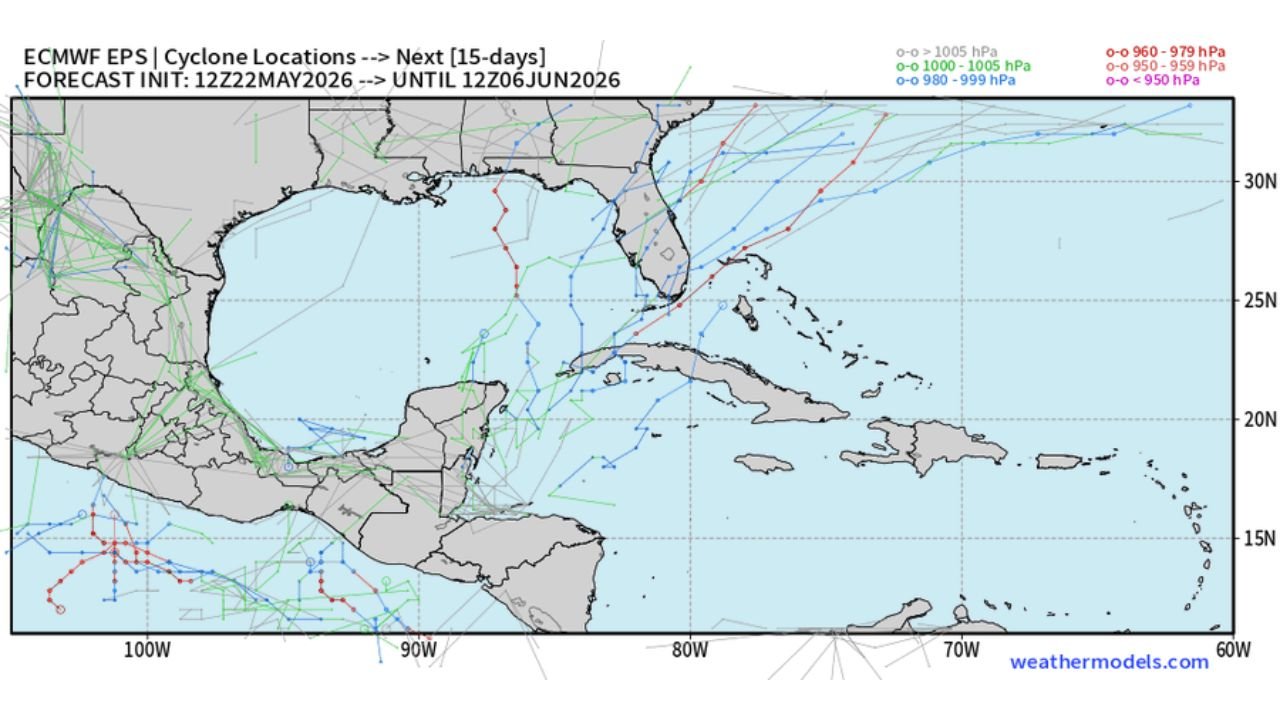
Two Areas Being Watched for Development
Ensemble track data covering the next 15 days is highlighting two primary areas of interest for potential tropical development:
Area 1: Waters off the southeastern United States just south of the Gulf Stream, where multiple ensemble members are suggesting low pressure organization could occur as the calendar turns toward June.
Area 2: The Caribbean Sea, where ensemble data shows something trying to lift northward out of the tropics, with several track solutions showing movement toward the Gulf of Mexico, Florida, and the broader southeastern United States.
The Uncertainty Is Still Very High
Forecasters are being direct about what is known and what is not. The origin point of where any system develops remains the biggest open question. With ensemble members showing a wide spread of possible track solutions ranging from the western Gulf of Mexico through the Florida Straits and up the East Coast, the uncertainty window is still too large to draw confident conclusions about landfall threats or specific impacts.
What the Ensemble Tracks Are Showing
The 15-day cyclone location map shows a dense cluster of track solutions across the Caribbean and Gulf region, with:
- Several weaker systems tracking across the Gulf of Mexico
- Track solutions showing potential movement toward Florida and the southeastern coast
- A smaller number of more intense track members indicated by the red colored solutions in the ensemble spread
- Systems lifting out of the Caribbean northward toward the Gulf Stream region
Why This Matters Heading Into June
With Atlantic hurricane season beginning June 1, the timing of these tropical signals is significant. The same elevated moisture and low pressure anomalies that have been producing heavy rainfall across the Gulf Coast and Southeast over the past week are the same ingredients that support tropical development in the warm waters of the Caribbean and Gulf. As confidence in the pattern increases, the level of monitoring on these signals will intensify.
Stay with CabarrusWeekly.com for daily tropical weather updates as hurricane season begins and these early June development signals continue to be evaluated.