
Michigan Travel Conditions Shift Sharply After Christmas as Winter System Brings Snow, Ice, and Hazardous Roads Friday
MICHIGAN — Travel conditions across Michigan are expected to change dramatically after Christmas Day as a developing winter weather system brings a mix of snow, sleet, and freezing rain into the state on Friday, creating hazardous driving conditions in several regions. While Christmas Day itself is expected to remain relatively calm for travel, the situation deteriorates quickly heading into Friday and Friday night.
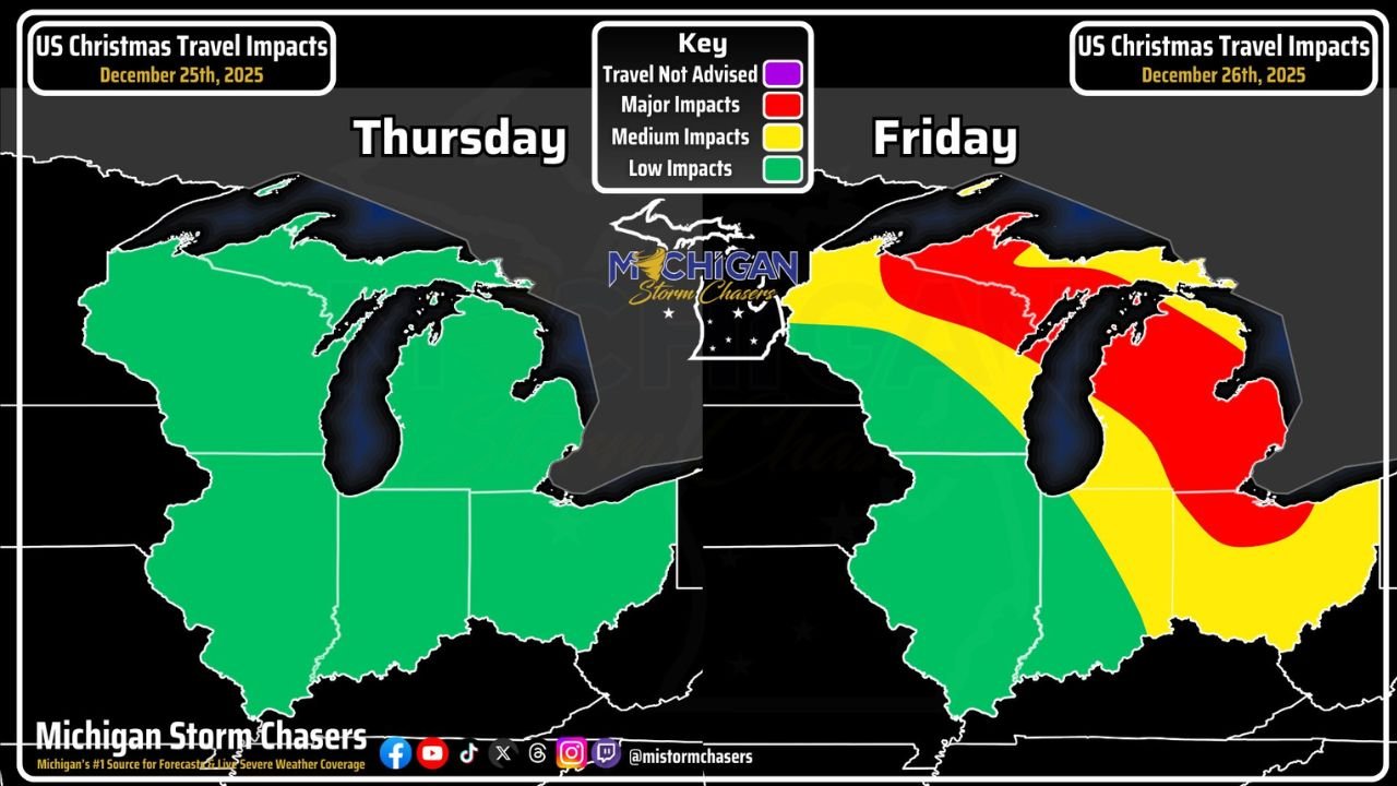
Forecast data shows a clear contrast between the two days. On Thursday, most of Michigan experiences low travel impacts, allowing holiday travel to proceed without major weather interference. By Friday, however, mixed precipitation spreads across the state, leading to medium to major travel disruptions, particularly in a narrow but significant corridor where conditions may become dangerous.
Christmas Day Travel Expected To Remain Manageable Statewide
Travel across Michigan on Christmas Day is expected to be largely uneventful from a weather standpoint. Forecast maps indicate low-impact conditions across the entire state, with no major winter hazards anticipated during the daytime hours.
Drivers may still encounter typical holiday congestion, but weather-related slowdowns are not expected to be a primary concern. Officials continue to urge patience and safe driving practices due to increased traffic volume rather than winter conditions.
Friday Brings Sharp Increase In Winter Travel Impacts
Conditions shift rapidly on Friday as a winter system moves through the Great Lakes region. Forecast guidance highlights statewide medium impacts, with a concentrated corridor of major impacts developing as mixed precipitation overspreads Michigan.
This corridor is expected to experience snow changing to sleet and freezing rain, creating slick roadways and reduced visibility. The combination of precipitation types raises concerns for rapid ice accumulation in localized areas, which could make travel extremely difficult within a short time frame.
Major Impact Corridor Could Create Dangerous Driving Conditions
The most serious travel concerns on Friday center on a narrow band of major impacts where road conditions may quickly deteriorate. These areas are expected to see the highest risk of icing, increasing the likelihood of accidents, spin-outs, and road closures.
Even areas classified under medium impacts could still experience dangerous conditions, especially during periods of heavier precipitation or rapid temperature changes. Officials emphasize that conditions may vary significantly over short distances.
Drivers Urged To Use Caution As Forecast Continues To Evolve
Forecasters note that while the overall pattern is becoming clearer, small shifts in temperature or precipitation type could significantly change impact levels, particularly within the major impact corridor. Travelers are urged to monitor updates closely as the system approaches.
Drivers are advised to:
- Allow extra travel time on Friday
- Reduce speeds on slick roadways
- Avoid unnecessary travel during periods of heavier precipitation
- Stay informed through local weather updates
No major changes to the forecast are anticipated at this time, but updates will be issued if conditions evolve.
WaldronNews.com will continue tracking winter travel conditions across Michigan and provide updates as new forecast information becomes available. Readers are encouraged to check back frequently and share road conditions from their area to help keep others informed.