
New York, Pennsylvania, New Jersey Winter Storm Forecast Shows Narrow Heavy Snow Corridor With Ice Risk December 26–27
UNITED STATES — A developing winter storm is expected to impact parts of New York, Pennsylvania, and New Jersey late Friday into Saturday morning, with forecast data showing a narrow northwest-to-southeast corridor of plowable snowfall, surrounded by areas vulnerable to mixing, sleet, and freezing rain.
Meteorologists caution that small shifts in storm track could result in sharp changes in snowfall totals over short distances, making this a high-uncertainty but potentially disruptive system.
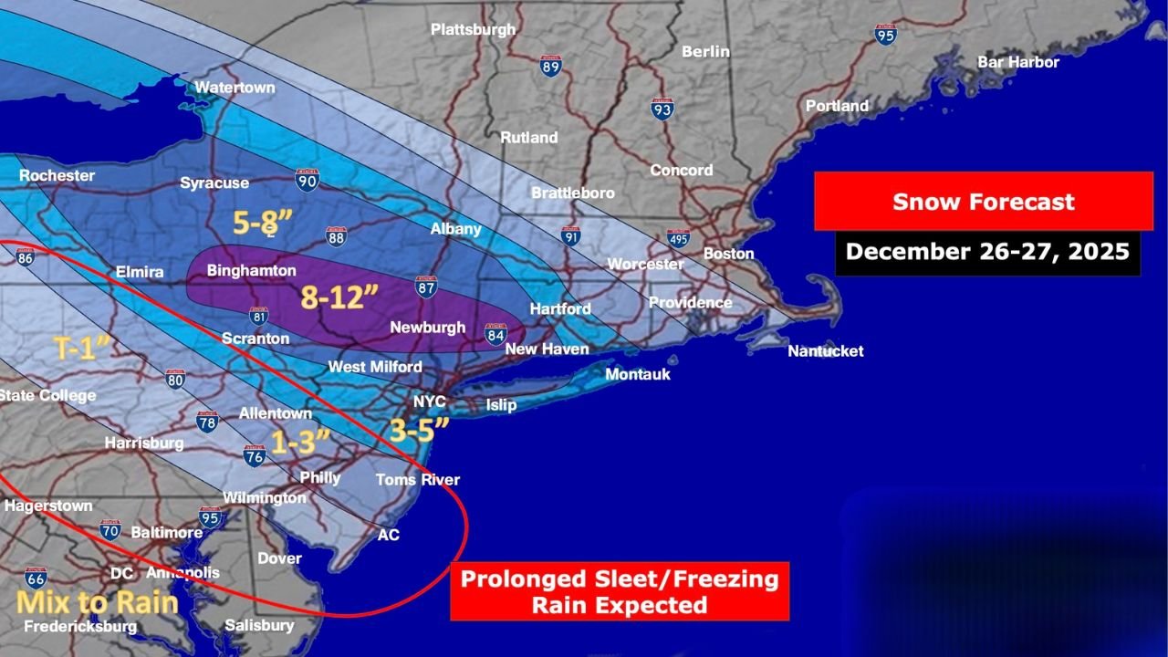
Narrow Band Of Heaviest Snow Expected From Central New York Into Southern New England
Forecast maps indicate the highest snowfall totals — ranging from 8 to 12 inches — are most likely in a narrow zone extending from Binghamton, New York, eastward toward parts of the Hudson Valley and western Connecticut, where atmospheric conditions favor strong snow banding and efficient snow growth.
Areas just north of this corridor, including portions of central and eastern New York, may see moderate accumulations of 5 to 8 inches, while snowfall totals drop off rapidly to the northeast due to intrusions of drier air.
Snow Totals Decrease Quickly To The Southwest Due To Mixing
South and southwest of the primary snow band, including eastern Pennsylvania, southern New Jersey, and parts of Maryland, temperatures and warm air aloft are expected to cause precipitation to transition from snow to sleet and freezing rain, sharply reducing snow totals.
Forecast guidance shows 1 to 3 inches of snow in areas such as Philadelphia and surrounding suburbs, while locations closer to the Interstate 95 corridor may see limited snow accumulation before a changeover.
Prolonged Freezing Rain And Sleet A Concern In Transition Zone
The storm’s most hazardous impacts may occur within the transition zone, where prolonged sleet and freezing rain are expected late Friday into early Saturday. This region includes parts of eastern Pennsylvania, northern New Jersey, and southern New York, where icy road conditions could develop even with relatively low snowfall totals.
Forecasters warn that travel conditions could deteriorate rapidly overnight, especially on untreated roads and elevated surfaces.
Timing And Travel Impacts
Snow and mixed precipitation are expected to develop late Friday, intensify overnight, and taper off Saturday morning. The timing places the worst impacts during overnight travel and early Saturday commutes, increasing the risk of accidents and delays.
Because the storm’s heavy snow band is narrow, officials emphasize that two nearby communities may experience dramatically different conditions depending on storm evolution.
Forecast Adjustments Likely As Storm Approaches
Meteorologists stress that snowfall totals and precipitation types will continue to be adjusted as higher-resolution data becomes available. Residents across the impacted states are urged to monitor updated forecasts and prepare for rapidly changing winter weather conditions.
Drivers are advised to avoid unnecessary travel during peak impacts, allow extra time, and remain alert for icy surfaces even in areas receiving modest snowfall.