
Major Winter Storm to Impact New York, Pennsylvania, West Virginia, and Maryland With Heavy Snow and Dangerous Ice From Friday Into Saturday
UNITED STATES — A significant winter storm is set to impact large portions of the Northeast and Mid-Atlantic from Friday into Saturday (December 26–27), bringing a dangerous mix of heavy snow and ice that could severely disrupt travel and daily life across several states.
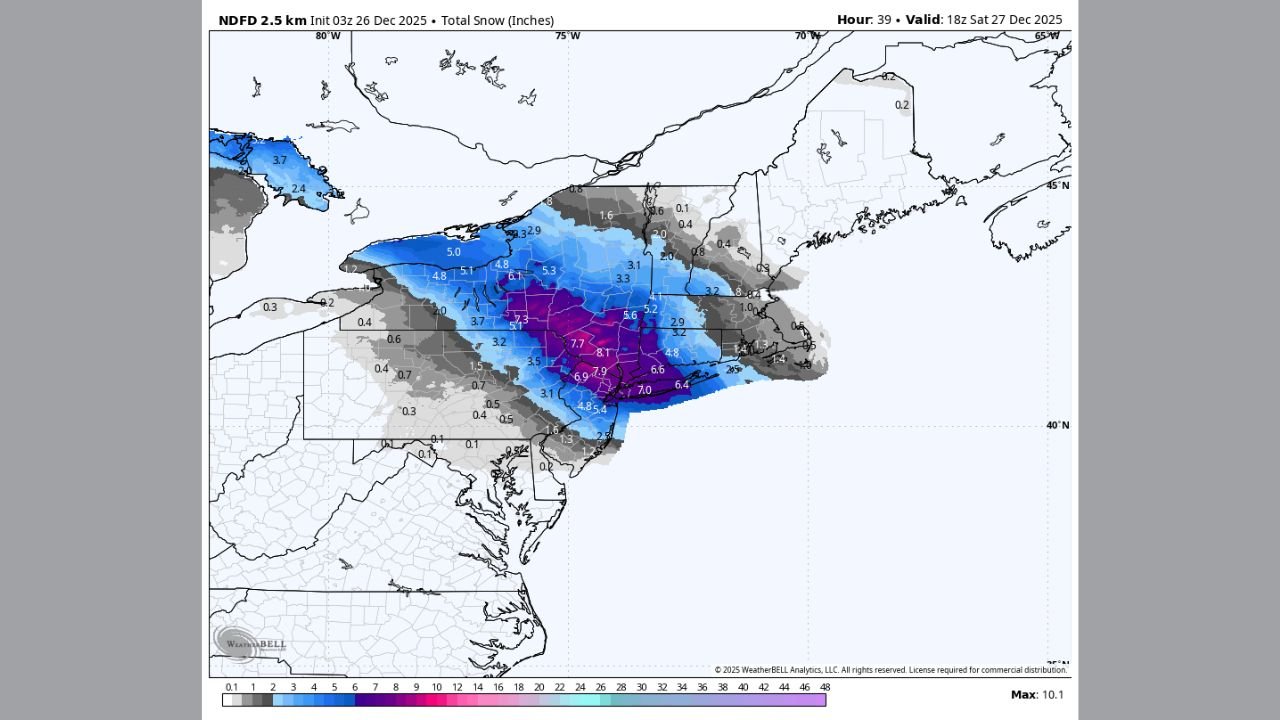
Forecast guidance shows heavy accumulating snow across parts of New York, including Long Island, while significant ice accretion threatens portions of Pennsylvania, western New York, West Virginia, and Maryland, creating a high-risk situation for power outages and hazardous road conditions.
Heavy Snow Targets New York, Including Long Island
Snowfall models consistently indicate a focused band of 6 to 8 inches of snow across parts of New York, with the heaviest totals centered over Long Island and nearby inland areas.
The snow is expected to fall at a steady to occasionally heavy rate, allowing accumulations to build quickly. Cold surface temperatures will support mostly snow, limiting mixing issues in these areas and increasing confidence in impactful totals.
Major roadways, including coastal and suburban corridors, may become snow-covered during the height of the storm, particularly late Friday into early Saturday.
Ice Storm Threat Expands Across Pennsylvania and the Mid-Atlantic
Farther southwest, the storm takes on a more dangerous character as freezing rain becomes the dominant threat.
Forecast data shows significant ice accretion across:
- Central and eastern Pennsylvania
- Western New York
- Northern West Virginia
- Western and central Maryland
Ice accumulations in these regions could reach levels capable of downing trees and power lines, especially where freezing rain persists for several hours. Even modest ice amounts can cause major issues when combined with gusty winds and cold ground temperatures.
Why This Storm Is Especially Dangerous
The storm’s impact is driven by a sharp temperature contrast in the atmosphere:
- Surface temperatures remain below freezing
- A warm layer aloft allows rain to fall before freezing on contact
This setup creates a narrow but intense ice zone, where conditions can change rapidly over short distances. Areas just north may receive snow, while areas just south experience damaging ice — making forecasting and preparation especially challenging.
Travel and Power Outage Concerns
Residents across the affected states should prepare for:
- Extremely slick roads, especially untreated surfaces
- Tree damage and scattered power outages in ice-prone areas
- Rapidly changing conditions overnight Friday into Saturday
Travel is strongly discouraged during the height of the storm, particularly in regions expecting freezing rain, where even a thin glaze of ice can make driving nearly impossible.
Timing and Duration
- Friday afternoon into evening: Snow and ice develop across the region
- Overnight Friday: Peak impacts for both snow and freezing rain
- Saturday morning: Gradual tapering, though lingering hazards remain
Even after precipitation ends, icy road conditions may persist well into Saturday, especially in shaded and elevated areas.
Bottom Line
This is shaping up to be a high-impact winter storm for parts of New York, Pennsylvania, West Virginia, and Maryland, with heavy snow in New York and a serious ice storm threat farther south and west. Residents should finalize preparations, avoid unnecessary travel, and stay alert for local advisories and power outage updates.
WaldronNews.com will continue monitoring this developing winter storm and provide additional updates as new forecast data becomes available.