
Ice Storm Warnings Issued for Western Maryland as Dangerous Freezing Rain Threatens Northern Maryland, West Virginia, and Virginia
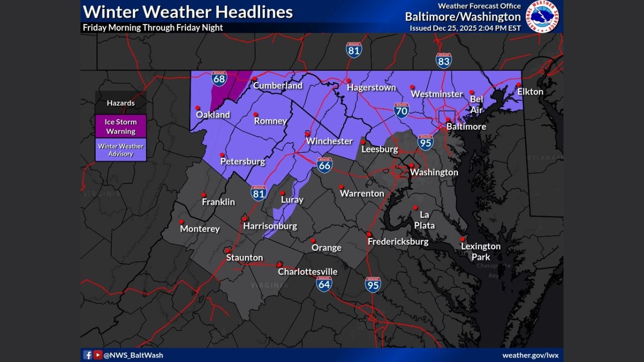
UNITED STATES — A dangerous winter weather event is unfolding across the Mid-Atlantic, with Ice Storm Warnings now in effect for western Maryland and widespread Winter Weather Advisories covering much of northern Maryland, eastern West Virginia, and parts of northern Virginia as freezing rain and sleet threaten to create hazardous conditions from Friday morning through Friday night.
The warnings and advisories were issued by the National Weather Service Baltimore/Washington office, highlighting a high risk for significant ice accretion, dangerous travel, and potential power outages.
Ice Storm Warnings Issued for Garrett and Allegany Counties
The most serious impacts are expected in eastern Garrett County and western Allegany County in Maryland, where Ice Storm Warnings have been issued.
In these areas, prolonged freezing rain is expected to lead to substantial ice buildup on roads, trees, and power lines. Even small increases in ice accumulation can dramatically increase the risk of:
- Tree limbs snapping under weight
- Downed power lines
- Extended power outages
- Nearly impassable road conditions
Officials urge residents in warned areas to avoid travel if possible and prepare for the possibility of losing power.
Winter Weather Advisories Cover Much of Northern Maryland
Beyond the ice storm warning zone, Winter Weather Advisories are in effect for the remainder of northern Maryland, including areas near Baltimore, Westminster, Hagerstown, and surrounding communities.
While ice totals may be lower than in western Maryland, freezing rain, sleet, and icy surfaces are still expected to cause significant travel issues, especially during the Friday commute and overnight hours.
Advisories Extend Into West Virginia and Virginia
The winter weather threat also stretches into:
- The eastern panhandle of West Virginia, including areas around Romney, Petersburg, and Winchester
- Portions of northern Virginia, particularly in higher elevations and areas closer to the Blue Ridge
These regions may see a mix of freezing rain and sleet, with surface temperatures remaining below freezing long enough to allow ice to accumulate.
Why This Setup Is So Dangerous
This storm features a classic freezing rain setup, where:
- Cold air is locked in at the surface
- Warmer air rides in above ground level
- Rain freezes instantly on contact with cold surfaces
This creates glaze ice, one of the most hazardous winter precipitation types due to its ability to quickly turn roads into skating rinks and overload trees and power infrastructure.
Timing and Key Impacts
- Friday morning: Freezing rain and sleet begin spreading across the region
- Friday afternoon and evening: Peak ice accumulation, highest risk for travel and outages
- Friday night: Precipitation gradually tapers, but icy conditions remain
Even after precipitation ends, roads and sidewalks may remain dangerously icy well into Saturday morning.
Safety and Travel Guidance
Residents in all affected areas should:
- Avoid unnecessary travel, especially during peak icing
- Prepare emergency kits in case of power outages
- Keep phones charged and monitor local alerts
- Use extreme caution on bridges, overpasses, and untreated roads
Bottom Line
A high-impact ice storm is expected across western and northern Maryland, with freezing rain also affecting parts of West Virginia and Virginia. Ice Storm Warnings and Winter Weather Advisories highlight the potential for dangerous travel and power disruptions, particularly from Friday morning through Friday night.
WaldronNews.com will continue to monitor this developing situation and provide updates as conditions change and new alerts are issued.