
Severe Thunderstorm Warning Remains in Effect for Cincinnati, Ohio and Northern Kentucky as 60-MPH Winds Threaten Area Until 11 PM EST
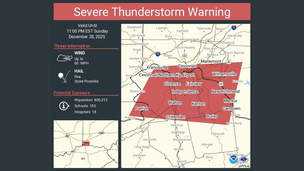
CINCINNATI, OHIO — A Severe Thunderstorm Warning remains in effect until 11:00 p.m. EST Sunday night for Cincinnati, Ohio, along with Covington, Florence, Independence, and the Cincinnati–Northern Kentucky International Airport area, as a strong line of storms moves through the region bringing the threat of damaging winds and hail.
According to the warning area shown on the latest alert map, storms are impacting Hamilton County in Ohio and Boone, Kenton, and Campbell counties in Kentucky, placing hundreds of thousands of residents under immediate severe weather risk.
Damaging Winds and Hail Are the Primary Threats
The strongest storms within the warning area are capable of producing wind gusts up to 60 mph, which can:
- Down trees and large branches
- Damage roofs and siding
- Cause scattered power outages
In addition to strong winds, pea-sized hail is possible, especially in the heaviest storm cores. While hail sizes are expected to remain relatively small, sudden bursts can still reduce visibility and make driving dangerous.
High Population Exposure Across the Metro Area
The warned area includes a large and densely populated region, with an estimated:
- Population: Over 800,000 people
- Schools: More than 180
- Hospitals: Nearly 20 medical facilities
This increases the potential for widespread impacts, particularly during the evening hours when many people may still be traveling.
Storm Timing and Movement
The severe thunderstorm activity is expected to continue through late evening, with storms moving generally eastward across the Ohio–Kentucky border region. Conditions may change rapidly, and additional warnings could be issued if storms intensify or new cells develop.
Residents should be aware that storms can strengthen quickly, even if rain initially appears light.
Safety Guidance for Residents
Officials urge everyone in the warned area to take precautions:
- Move indoors and stay away from windows
- Secure loose outdoor objects
- Avoid driving through heavy rain or debris-covered roads
- Be alert for falling tree limbs or power lines
If you are near the Cincinnati–Northern Kentucky International Airport, expect possible delays or ground operations disruptions due to lightning and strong winds.
What Happens After 11 PM
While the current warning is set to expire at 11:00 p.m. EST, additional alerts may follow depending on storm evolution. Even after storms weaken, lingering gusty winds and scattered outages may continue into the night.
Are storms impacting your area right now?
Have you seen strong winds, hail, or power issues where you live? Share your updates and stay informed with ongoing severe weather coverage at WaldronNews.com.