
Dryline Tightening Across Texas and Oklahoma as Supercells With Strong Tornadoes and All Hazards Threat Expected to Fire Between 4 PM and 7 PM Targeting Southwest Oklahoma, Northwest Texas and Central Eastern Kansas
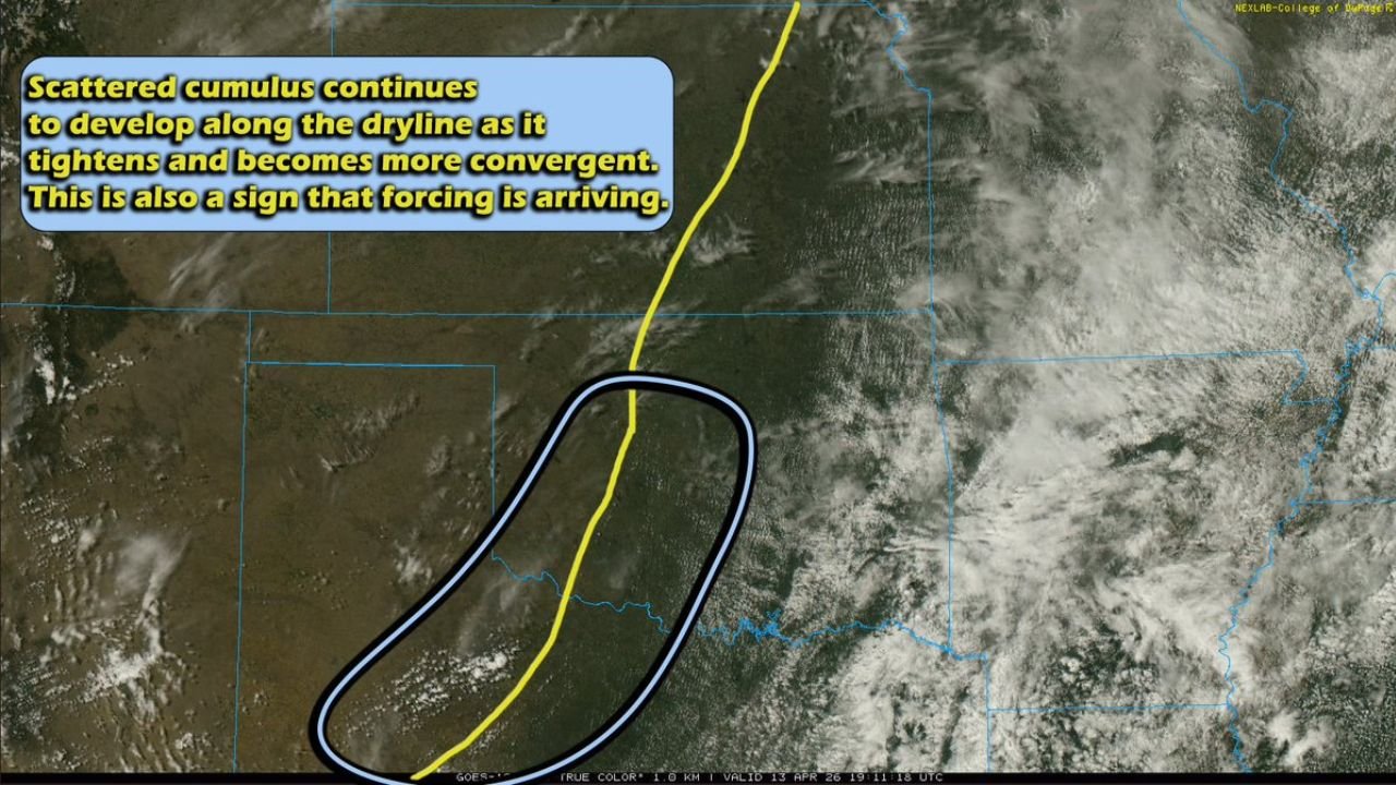
OKLAHOMA CITY, Oklahoma — A dangerous and rapidly evolving severe weather situation is developing right now across Texas and Oklahoma as a tightening and converging dryline advances eastward through the region — with scattered cumulus clouds already building along the boundary as atmospheric forcing arrives, signaling that supercell thunderstorms are on the verge of firing across southwest Oklahoma, northwest Texas, and central-eastern Kansas during a critical window between 4:00 PM and 7:00 PM today, with storms most likely beginning around 5:00 PM.
The dryline — the sharp boundary separating hot, dry air from the west and warm, moist Gulf air from the east — is tightening and becoming more convergent across the region right now, and that convergence is one of the clearest real-time signals that the atmosphere is preparing to release its stored energy into organized, dangerous thunderstorms. If supercells develop along this boundary this afternoon, the environment will support a significant all-hazard severe weather threat including strong tornadoes, large hail, and damaging winds.
Where Storms Will Fire — Three Focused Areas
Storm development could occur anywhere along the dryline as a seasonably moist environment continues building across Texas and Oklahoma — but three specific areas are identified as the most focused targets for supercell development this afternoon:
- Southwest Oklahoma: The primary and most focused area for storm development — supercells firing here will immediately enter an environment supportive of all severe hazards including strong tornadoes
- Northwest Texas: A second concentrated area of storm development potential along the dryline as it tightens across the Texas Panhandle and surrounding region — storms here could also produce significant severe weather if they can organize as discrete supercells
- Central-Eastern Kansas: A third area of storm development potential as the dryline advances eastward — storms firing in this zone would track into a moist and unstable environment capable of supporting supercells with tornado and large hail potential
What Happens Between 4 PM and 7 PM
The storm initiation window is now firmly established. Storms are expected to begin firing along the dryline between 4:00 PM and 7:00 PM, with 5:00 PM identified as the most likely time for the first significant supercells to develop across the primary threat areas.
This afternoon timing is significant for two reasons. First, 5:00 PM coincides with peak surface heating — the maximum instability of the day — meaning storms that develop during this window will have access to the most atmospheric energy available. Second, the 4 to 7 PM window falls directly during evening commute hours across Oklahoma City, the surrounding southwest Oklahoma communities, and the northwest Texas corridor — putting millions of people potentially on the road when tornado warnings could be issued with short lead times.
The convergence already visible on satellite imagery — with scattered cumulus clouds developing both along and behind the dryline — confirms that forcing is actively arriving at the boundary right now. This is real-time confirmation that the afternoon storm initiation sequence is already in motion.
The All-Hazard Threat — What Supercells Will Carry
If supercells can develop and maintain their discrete structure along the dryline across southwest Oklahoma and northwest Texas, the environment will be supportive of:
Strong Tornadoes: A few tornadoes are possible with this setup — and the word used is strong, meaning EF2 or potentially higher ratings are on the table if supercells can fully tap into the moist and unstable environment east of the dryline. The dryline is one of the most prolific tornado-producing boundaries in North America, and today’s tightening and convergent setup provides the trigger mechanism that the atmosphere needs to release its stored energy into organized rotating storms.
Large Hail: Any supercell that develops this afternoon will carry significant hail potential. The instability and moisture in place across the southwest Oklahoma and northwest Texas corridor is sufficient to support hailstones well above the severe threshold of one inch in diameter.
Damaging Winds: Straight-line wind damage is possible with any supercell or storm cluster that develops along today’s dryline, particularly if storms evolve into a more linear mode during the evening hours after the initial discrete supercell phase.
Why Southwest Oklahoma and Northwest Texas Are the Primary Targets
The satellite imagery clearly shows the primary development zone — outlined in the dark blue oval on the visible satellite image — concentrated across southwest Oklahoma and northwest Texas where the dryline is most tightly converged and the cumulus development is most active. This is where the atmosphere is working hardest right now to initiate convection, and it is where the first and potentially strongest supercells of the afternoon are most likely to develop.
Southwest Oklahoma sits in a particularly favorable position today because it lies directly in the zone where the moist Gulf air streaming northward meets the converging dryline at its sharpest point. Supercells that fire here have immediate access to deep moisture, sufficient instability, and the wind shear needed to maintain organized rotation for extended periods as they track east and northeast across the region.
Central-eastern Kansas represents the northern end of today’s threat corridor — as the dryline advances eastward through Kansas, a separate area of storm development potential exists that could produce additional supercells tracking into the already storm-active environment across the central Plains this afternoon and evening.
What Oklahoma, Texas and Kansas Residents Must Do Before 4 PM
- Residents across southwest Oklahoma — including Lawton, Altus, Chickasha, and surrounding communities — are in the primary supercell development zone. Be sheltered and weather-aware before 4:00 PM
- Northwest Texas communities including Amarillo, Lubbock, and the Texas Panhandle should have weather alerts active and shelter plans confirmed before 5:00 PM when storms are most likely to begin firing
- Central-eastern Kansas residents near Wichita, Salina, and the eastern Kansas corridor should monitor the dryline’s eastward advance closely through the afternoon as storm development potential in this zone increases
- Evening commuters across Oklahoma City and the broader southwest Oklahoma region should check weather conditions before leaving work today — if tornado warnings are issued during the 5 to 7 PM window, pull over and seek sturdy shelter immediately rather than attempting to outrun storms
- Do not wait for a tornado to be confirmed before moving toward shelter — dryline supercells can produce tornadoes within minutes of first developing, leaving very little warning time
- Monitor conditions continuously from now through 7:00 PM — the storm initiation window is active and evolving in real time
The dryline is tightening, the forcing is arriving, and southwest Oklahoma, northwest Texas, and central-eastern Kansas are entering the most dangerous hours of the afternoon. The 4 to 7 PM window is when this situation becomes most critical — and every resident in the threat zone needs to be prepared before that window opens.
WaldronNews.com will continue tracking dryline storm development across Oklahoma, Texas, and Kansas and will provide updates as supercells develop, warnings are issued, and the severe weather situation evolves through this evening.