
Extreme “Blue Norther” Slams Midwest, Great Lakes, and Northeast With Historic 40–60 Degree Temperature Crash
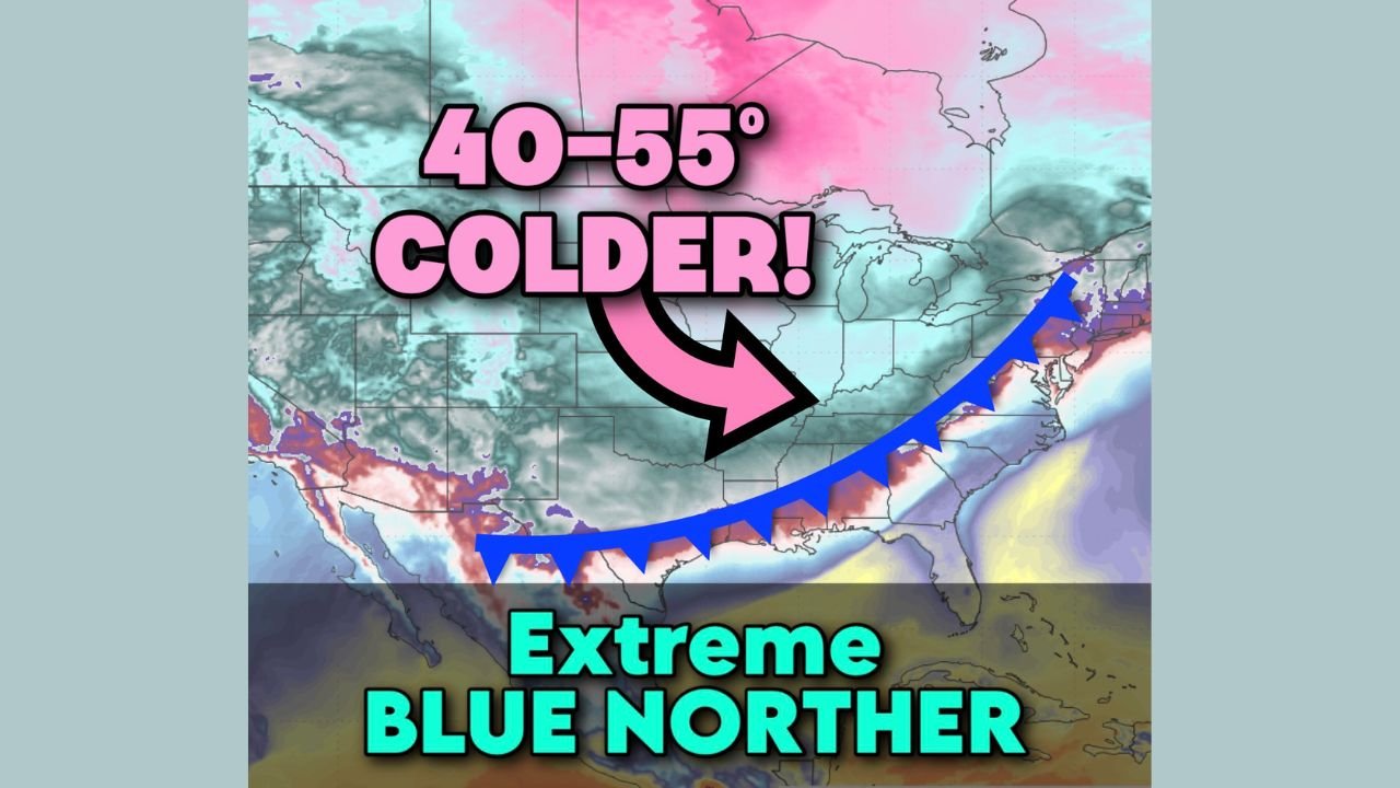
UNITED STATES — A powerful Arctic cold front known as a “blue norther” tore across the Midwest, Great Lakes, and Northeast states, triggering historic temperature drops of 40 to 60 degrees within hours and unleashing a dangerous mix of severe thunderstorms, tornado damage, blizzard conditions, and ice storms.
Meteorologists say the speed and intensity of the system caused weather conditions to flip from summer-like warmth to mid-winter cold in less than a day, catching many communities off guard.
Historic Temperature Drops Recorded Across Missouri, Illinois, and Indiana
Some of the most extreme temperature collapses were observed in Missouri, where readings fell at near-record rates.
- St. Louis, Missouri plunged from 78.1°F Sunday afternoon to 19°F with snow by 3 a.m., marking what may be the airport’s largest 13-hour temperature drop on record
- Anthony, Missouri dropped from 73.2°F to 19.4°F
- Kaiser Lake Ozark, Missouri fell from 74°F to 13°F
- Jefferson City, Missouri dropped from 73.9°F to 14°F, a 60-degree crash
In neighboring states, Chicago, Illinois recorded a 36-degree drop, while Indianapolis, Indiana fell 47 degrees, sliding from 66.9°F to 14°F.
Meteorologists noted the event rivals the infamous November 11, 1911 blue norther, when St. Louis experienced a 64-degree temperature collapse.
Severe Thunderstorms and Tornado Damage Reported in Illinois, Indiana, and Kentucky
As warm and cold air masses collided, the system produced severe thunderstorms across Illinois, Indiana, and Kentucky, some turning destructive before temperatures crashed.
- Tazewell County, Illinois reported EF1 to low-end EF2 tornado damage
- Mt. Zion, Illinois saw multiple homes destroyed
- Damaging winds and hail were reported along the storm line
Emergency officials warned that the rapid weather transition significantly increased danger, giving residents little time to react.
Blizzard Conditions Grip Michigan’s Upper Peninsula
Behind the cold front, powerful winds and intense snowfall battered the Great Lakes region, with the most severe impacts in Michigan’s Upper Peninsula.
- Blizzard conditions reduced visibility to near zero
- Snow totals reached up to 2 feet
- Subzero wind chills made travel extremely dangerous
Road closures and emergency travel advisories were issued as whiteout conditions persisted.
Ice Storm Impacts New York, Vermont, and New Hampshire
As the system moved east, it transitioned into a major ice storm across northern New England and Upstate New York.
- Upstate New York recorded ice accretion up to 0.64 inches
- Northern Vermont and New Hampshire saw 0.4 to 0.5 inches of ice
- Ice buildup led to hazardous roads and the risk of power outages
Meteorologists warned that ice accumulations of this magnitude can bring down trees and power lines.
Dangerous Cold Expected to Linger
Forecasters say the weather pattern responsible for this event remains active, meaning continued cold and additional winter hazards are possible in the days ahead across already impacted regions.
Residents are urged to limit travel, protect exposed pipes, check on vulnerable neighbors, and closely monitor local forecasts as conditions evolve.
Have you experienced record cold, storm damage, snow, or ice where you live? Share your updates and follow continuing weather coverage at WaldronNews.com.