
New York Lake Effect Snow Expected to Bury Buffalo’s Southtowns With 18–36 Inches of Snow
NEW YORK — A prolonged lake effect snow event is setting up across western and central New York, with forecasters warning that snowfall totals could reach 18 to 36 inches in parts of the Buffalo Southtowns over the next several days as persistent snow bands remain locked in place.
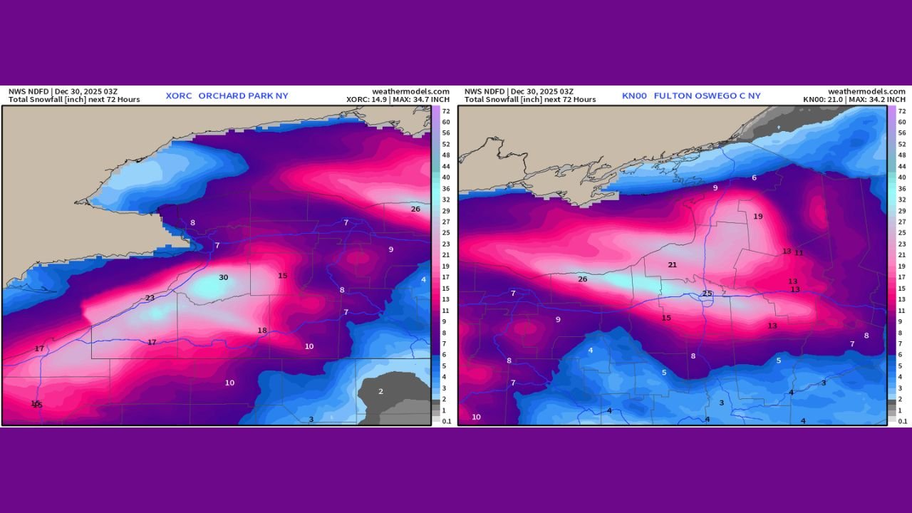
The heaviest accumulations are expected just south of Buffalo along the Lake Erie shoreline, where intense lake effect bands may drift or repeatedly move over the same areas, leading to dangerous travel and rapidly worsening conditions.
Buffalo Southtowns Could See Up to Three Feet of Snow
Forecast models indicate that communities south of Buffalo could experience snowfall rates strong enough to produce over three feet of accumulation, particularly where bands remain stationary.
Areas near Orchard Park and surrounding Southtown communities are positioned directly within the highest-impact zone, where snow is expected to pile up quickly and continue for multiple days.
Drifting snow and reduced visibility will likely make roads impassable at times, especially during periods of peak snowfall.
Lake Erie Shoreline Expected to Receive 18–24 Inches
Along the immediate Lake Erie shoreline, snowfall totals of 18 to 24 inches are forecast as cold air continues to flow over the relatively warm lake surface.
This temperature contrast is fueling persistent lake effect snow bands capable of producing heavy, localized accumulation in a short period of time.
Even slight shifts in wind direction could dramatically change where the heaviest snow falls.
Heavy Snow Also Targeting Lake Ontario and Tug Hill Plateau
In addition to western New York, areas east of Lake Ontario are also expected to see significant snowfall.
The Tug Hill Plateau could receive 2 feet or more of snow, with bands extending inland and producing widespread accumulation across central and northern portions of the state.
Travel conditions in these regions are expected to deteriorate quickly as snow continues to fall and visibility drops.
Dangerous Travel and Power Disruptions Possible
The prolonged nature of this lake effect event increases the risk of:
- Snow-covered and icy roads
- Whiteout conditions in heavier bands
- Vehicle slide-offs and accidents
- Possible power outages from heavy snow loading
Officials urge residents to avoid unnecessary travel, especially during periods of intense snowfall.
Snow Bands May Persist for Several Days
Unlike fast-moving winter systems, lake effect snow can linger for days. Forecast guidance shows snow bands remaining active through the coming days, with additional accumulation possible even after the heaviest snow falls.
Residents in affected areas should prepare for extended winter conditions, including difficult commutes, snow removal challenges, and limited visibility.
Residents across New York are encouraged to stay weather-aware, monitor local advisories, and take precautions as this significant lake effect snow event unfolds.
For continued updates and detailed local coverage, follow WaldronNews.com and share your snow totals and conditions with our newsroom.