
Severe Storm Threat Develops for Florida, Georgia, South Carolina, and Alabama as Modest Surface Low Brings Heavy Rain and Gusty Winds Friday–Saturday
UNITED STATES — Forecasters are closely monitoring a developing weather pattern that could bring increased storm chances to parts of the Southeast and Florida late this week, as a modest surface low pressure system moves east across the southern United States.
According to early model guidance and Storm Prediction Center discussions, the system is expected to dip across the lower U.S. and into the Southeast, potentially enhancing rainfall, thunderstorms, and gusty winds from Friday into Saturday. While details remain uncertain at this range, meteorologists say the setup is worth watching—especially for residents with outdoor plans.
What the Forecast Models Are Showing
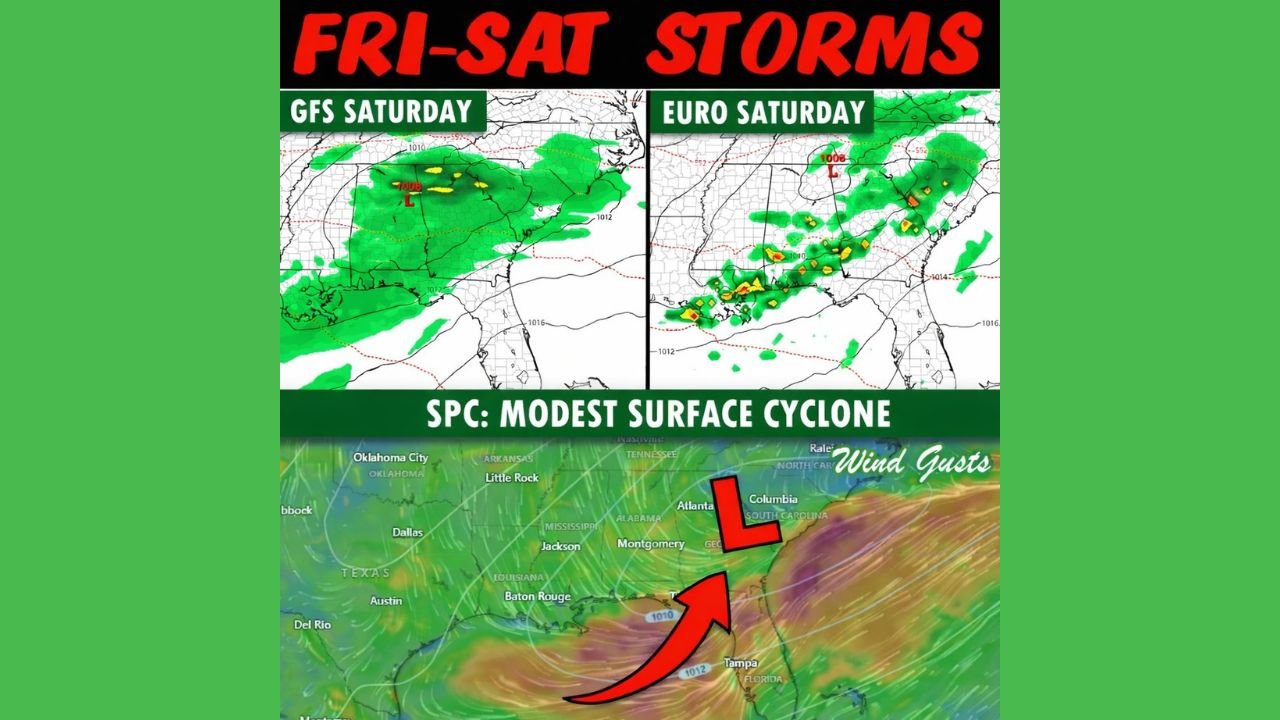
Forecast models, including both the GFS and European (EURO) solutions, indicate a weak but organized surface cyclone forming and tracking eastward across the southern tier of the country.
Model simulations suggest:
- Widespread rain developing across parts of the Gulf Coast and Southeast
- Embedded thunderstorms possible as moisture increases
- Gusty winds near and east of the developing low
- Storm activity expanding toward Georgia, the Carolinas, and northern Florida
At this time, the Storm Prediction Center has described the feature as a “modest surface cyclone,” meaning severe weather is not guaranteed, but localized impacts are possible if conditions align.
Timing: Friday Into Saturday
Based on current guidance:
- Storm chances may begin increasing Friday
- The most active weather window appears to be Friday night into Saturday
- Impacts could extend eastward as the system approaches the Atlantic coast
Forecasters emphasize that timing and intensity could shift as the system comes into clearer focus over the next several days.
Why Confidence Is Still Limited
Meteorologists caution that this system is still several days away, placing it in what forecasters often call low-confidence model range. At this distance:
- Rain coverage may change
- Storm intensity could increase or weaken
- The strongest impacts may shift north or south
Experts stress that no snowfall totals, severe outbreak claims, or extreme impacts should be assumed at this stage, despite exaggerated graphics circulating online.
What Residents Should Do Now
While there is no immediate cause for alarm, residents across the Southeast and Florida should:
- Monitor updated forecasts through midweek
- Be mindful of outdoor plans late Friday and Saturday
- Stay weather-aware as confidence improves
Additional updates are expected as newer model runs refine the storm’s track and strength.
WaldronNews.com will continue to monitor this developing system and provide clear, verified updates as the forecast becomes more certain.