
Powerful Winter Storm Brings 66 MPH Wind Gusts and Several Inches of Snow to Central Pennsylvania
PENNSYLVANIA — A powerful winter storm swept across Central Pennsylvania between late December 29 and early December 30, 2025, producing damaging wind gusts, accumulating snowfall, and hazardous travel conditions across multiple counties, according to observed weather data compiled over a 36-hour period.
The storm delivered near-hurricane-force wind gusts in some locations and several inches of snow in higher elevations, confirming one of the more impactful winter systems to affect the region so far this season.
Wind Gusts Reached Dangerous Levels Across Central Pennsylvania
Observed data shows that wind gusts exceeded 60 miles per hour at several locations, with the strongest winds recorded at Johnstown Airport in Cambria County, where a peak gust of 66 mph was measured.
Other notable wind gusts across the region included:
- Manheim: 64 mph
- Mifflin County Airport: 61 mph
- Altoona–Blair County Airport: 60 mph
- Williamsburg: 59 mph
- Harrisburg International Airport: 58 mph
- Lancaster Airport: 56 mph
- State College (Beaver Stadium WxSTEM): 56 mph
Wind gusts of this magnitude are capable of downing trees, causing scattered power outages, and making travel difficult, particularly for high-profile vehicles.
Snowfall Totals Highest in Northern and Western Interior Areas
While snowfall amounts varied widely depending on elevation and location, several communities reported measurable accumulations, especially in north-central and western portions of Central Pennsylvania.
The highest observed snowfall totals included:
- Russell Township (Warren County): 4.5 inches
- Russell (4.7 miles west): 3.9 inches
- Ridgway: 3.0 inches
- Somerset: 2.0 inches
- Dubois: 1.8 inches
- Roulette: 1.5 inches
- Port Allegany: 1.0 inch
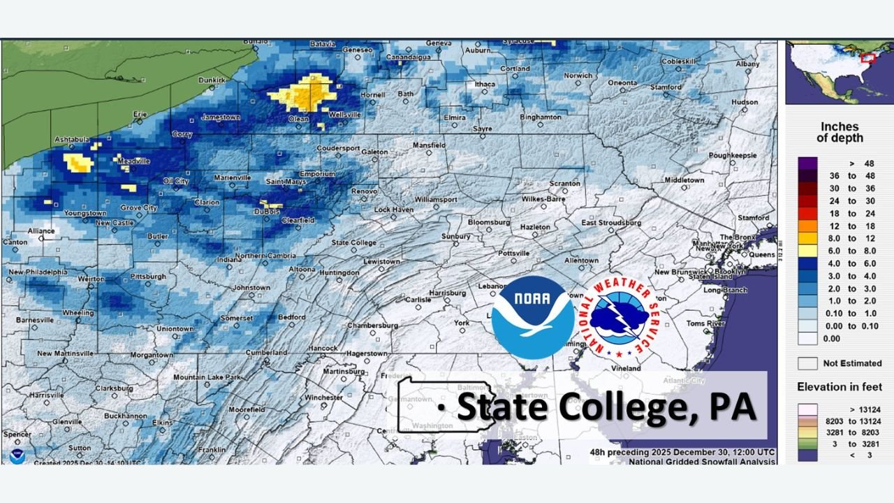
In State College, snowfall totals remained lighter, with most observations showing around half an inch or less, reflecting the storm’s sharp gradient between higher terrain and lower valleys.
Snowfall Pattern Matches Elevation and Lake-Enhanced Bands
Estimated snowfall maps indicate that heavier snow bands developed across higher elevations, particularly in areas north and west of State College, while southern and southeastern portions of Central Pennsylvania experienced lighter accumulations.
This pattern is consistent with cold northwest flow behind the storm system, which can enhance snowfall in elevated terrain and areas downwind of the Great Lakes, even as lower elevations see limited accumulation.
Impacts Included Hazardous Travel and Isolated Disruptions
The combination of strong winds and snowfall led to periods of reduced visibility, blowing snow, and slick road conditions, especially overnight and during early morning hours on December 30.
While widespread damage was not immediately reported, conditions were favorable for:
- Localized power outages
- Tree and limb damage
- Difficult travel on exposed roadways
Cold Pattern Continues to Support Winter Weather Risks
This storm comes as longer-range forecasts continue to indicate a colder-than-normal pattern developing across Pennsylvania as January progresses, increasing the likelihood of additional winter weather events in the weeks ahead.
Residents are encouraged to remain prepared for rapidly changing winter conditions, especially as stronger cold air masses move into the region.
Stay with WaldronNews.com for continued coverage of winter storms, cold weather impacts, and developing forecasts across Pennsylvania and beyond.