
Washington State Climate Recap 2025 Shows Unusual Heat, Below-Normal Precipitation, and Low Snowfall in Spokane, Lewiston, and Wenatchee
WASHINGTON — Newly released 2025 climate data for eastern and central Washington shows a year marked by above-normal temperatures, reduced precipitation, and notably low snowfall, with Spokane, Lewiston, and Wenatchee all finishing the year warmer and drier than average. The data highlights growing climate variability across the Inland Northwest, including the fact that Spokane did not reach 100°F at any point during 2025, an uncommon detail in an otherwise warm year.
Spokane Records Warm Year Without Reaching 100°F
Spokane finished 2025 with an average temperature of 51.4°F, making it the fourth-warmest year on record compared to a normal of 48.6°F. Despite the warmth, the city’s highest temperature was 99°F, recorded on September 1 and 2, meaning Spokane narrowly avoided triple-digit heat all year.
The coldest temperature dropped to -4°F on February 12, highlighting sharp seasonal contrasts. Spokane also saw 26 days with temperatures at or above 90°F, exceeding the normal average of 21 days.
Precipitation totaled 14.88 inches, falling short of the normal 16.45 inches. Snowfall was especially low, with just 27.0 inches recorded, well below the normal 45.4 inches, ranking as the 24th-lowest snowfall year on record.
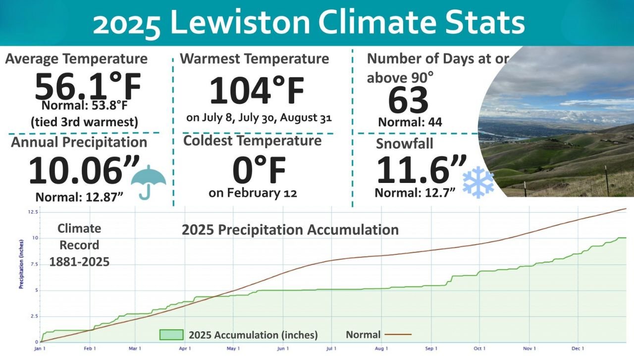
Lewiston Sees Extreme Heat and Fewer Winter Impacts
Lewiston experienced one of its warmer years on record, with an average temperature of 56.1°F, tying for the third-warmest year historically. The city recorded a peak temperature of 104°F, reached on July 8, July 30, and August 31.
Lewiston also logged 63 days at or above 90°F, far exceeding the normal 44 days, reinforcing how persistent summer heat was across the region. The coldest temperature dipped to 0°F on February 12.
Annual precipitation measured 10.06 inches, well below the normal 12.87 inches, while snowfall totaled 11.6 inches, slightly under the average of 12.7 inches. The data shows a continued trend toward hotter summers and reduced moisture, particularly in lower-elevation communities.
Wenatchee Warmer Than Normal With Limited Precipitation
Wenatchee recorded an average temperature of 53.9°F, tying for the second-warmest year on record, compared to a normal of 51.2°F. The warmest temperature reached 103°F on July 13, while the coldest temperature fell to 7°F on February 12 and 13.
The city experienced 42 days with temperatures at or above 90°F, exceeding the normal count of 35 days. Precipitation totaled 7.16 inches, slightly below the normal 7.83 inches, continuing a pattern of below-average moisture in central Washington.
What the 2025 Climate Data Signals
Across all three cities, the 2025 data points to longer warm seasons, fewer cold extremes, and declining snowfall totals, especially at lower elevations. While extreme heat events did occur, the absence of 100°F temperatures in Spokane stands out, suggesting warming trends do not always align with traditional heat benchmarks.
Reduced snowfall and precipitation can have downstream impacts on water supply, wildfire risk, agriculture, and regional ecosystems heading into future years, particularly if similar patterns persist.
Waldron News will continue monitoring regional climate trends and their potential impacts across Washington — share your thoughts on how 2025’s weather compared to past years, and follow Waldron News for continued coverage and updates.