
Great Lakes Ice Cover Reaches 12% as Lake Erie Freezes Faster Than Average While Lake Superior Lags Behind
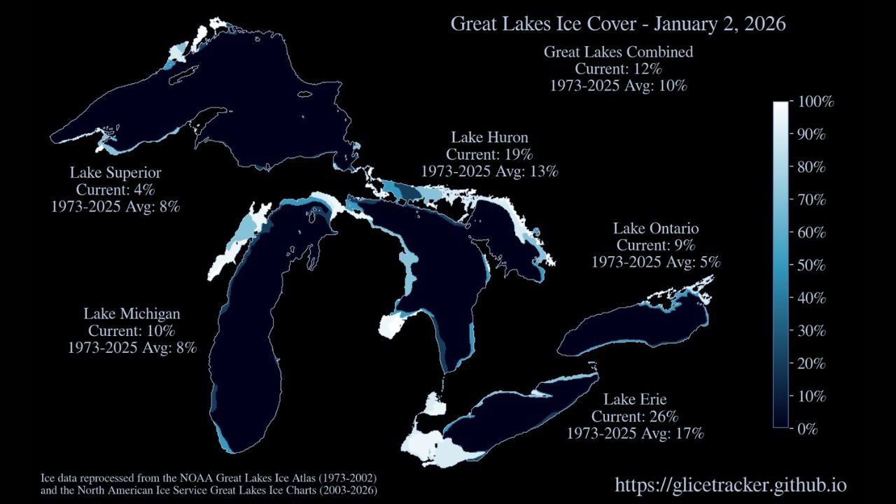
GREAT LAKES REGION — Newly released ice data for January 2, 2026, shows Great Lakes ice cover climbing to 12% overall, slightly above the long-term average for early January, with Lake Erie emerging as the most ice-covered lake while Lake Superior remains well below normal. The uneven freeze reflects a mix of recent cold snaps, persistent lake-effect activity, and a developing mid-January warm pattern.
The data highlights sharp contrasts across the region, with some lakes freezing faster than normal and others lagging behind due to their size, depth, and exposure to milder air.
Lake-by-Lake Ice Coverage Shows Sharp Differences
According to the latest analysis, Lake Erie currently has the highest ice coverage at 26%, well above its 1973–2025 average of 17%. The lake’s shallow depth allows it to freeze more quickly, especially after repeated cold outbreaks and sustained northwest flow.
Lake Huron is also running above average, with 19% ice cover compared to a normal 13%, while Lake Michigan sits at 10%, modestly above its long-term average of 8%.
In contrast, Lake Superior, the largest and deepest of the Great Lakes, shows only 4% ice coverage, which is half of its historical average of 8% for this point in the season. Lake Ontario stands at 9% ice cover, also above its typical 5% average, but remains far less frozen than Lake Erie.
Why Lake Erie Is Freezing Faster Than the Rest
Meteorologists note that Lake Erie’s shallow depth and narrower width make it especially sensitive to short-term cold spells. Recent lake-effect snow events, combined with overnight lows dipping well below freezing, have allowed ice to expand rapidly along the western and central basins.
Meanwhile, Lake Superior’s vast volume of water retains heat longer, delaying widespread ice formation even after several cold periods. Ice development there typically accelerates later in winter, particularly if sustained Arctic air arrives.
What This Means for Weather, Shipping, and Ice Safety
The expanding ice cover is already influencing lake-effect snow potential, especially downwind of Lake Erie and Lake Huron, where partial ice can either focus snow bands or suppress them depending on coverage and wind direction.
For commercial shipping, higher ice concentrations—especially on Lake Erie—can lead to slower transit times and increased reliance on icebreaking operations later this month.
Officials are also urging caution for recreational ice activity, noting that ice thickness remains highly uneven. Areas that appear frozen may still be unsafe, particularly near currents, shorelines, and inflow points.
Mid-January Warm Pattern Could Slow Ice Growth
Forecast trends suggest a mid-January warm spell across much of the Midwest and Northeast, which could temporarily stall or reverse ice expansion, especially on deeper lakes like Superior and Michigan. However, if colder air returns later in January, rapid ice growth could resume.
Historically, the Great Lakes experience their peak ice coverage in February, meaning significant changes—both increases and decreases—are still possible in the weeks ahead.
Residents, mariners, and winter recreation enthusiasts across the Great Lakes region are encouraged to monitor updated ice analyses and weather forecasts closely, as changing temperatures can quickly alter ice conditions. Stay informed, stay cautious, and continue following Waldron for the latest regional weather and climate updates.