
Major Mid-January Pattern Shift Brings Drier Weather to California, Oregon, and Washington After Weeks of Storms
CALIFORNIA — A significant atmospheric pattern change is expected to take hold along the West Coast during mid-January, bringing a sharp transition from weeks of stormy, flood-producing weather to a much drier and more stable setup across California, Oregon, and Washington, according to new outlooks from NOAA’s Climate Prediction Center.
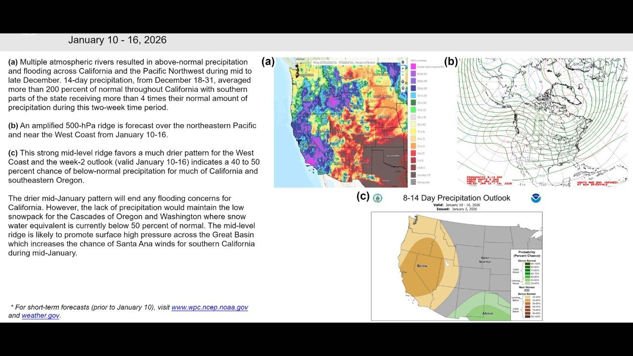
Forecast data valid January 10–16, 2026, shows a strong high-pressure ridge developing over the northeastern Pacific Ocean and extending inland, effectively shutting down the parade of Pacific storms that recently battered the region.
Atmospheric Rivers Fade After Widespread Flooding
The change follows an exceptionally active late-December period, during which multiple atmospheric rivers delivered well above-normal rainfall to much of California and the Pacific Northwest.
In parts of California, 14-day precipitation totals from December 18–31 exceeded 200 percent of normal, with some southern areas receiving more than four times their typical rainfall. These storms led to flooding concerns, saturated soils, and runoff issues—particularly in burn scar regions.
The new pattern marks a clear break from that wet regime.
High-Pressure Ridge Brings Dry Conditions to the West Coast
Forecast charts show an amplified mid-level ridge building over the northeastern Pacific and West Coast, a setup that strongly favors below-normal precipitation across:
- Most of California
- Large portions of Oregon
- Parts of Washington
The 8–14 day precipitation outlook indicates a 40–50 percent probability of drier-than-normal conditions, signaling a prolonged pause in storm activity.
This ridge acts as a blocking mechanism, steering Pacific systems north and preventing moisture from reaching the coast.
Flood Risk Decreases, But Snowpack Concerns Grow
While the dry stretch is expected to ease flooding risks in California, it may create new challenges farther north.
Snow water equivalent levels in the Cascades of Oregon and Washington are currently below 50 percent of normal, and the lack of incoming precipitation could further limit snowpack recovery during a critical part of winter.
A reduced snowpack can have long-term impacts on water supply heading into spring and summer.
Increased Santa Ana Wind Potential for Southern California
The developing ridge may also promote surface high pressure over the Great Basin, a pattern that historically increases the likelihood of Santa Ana wind events in Southern California.
These dry, gusty winds can elevate fire weather concerns, particularly in areas that experienced heavy vegetation growth earlier in the wet season followed by rapid drying.
What This Pattern Change Means Going Forward
- Storm activity across the West Coast is expected to significantly decrease
- Flooding threats in California should gradually diminish
- Snowpack deficits may worsen in the Pacific Northwest
- Fire-weather awareness may increase in Southern California
Forecasters note that while short-term conditions are becoming quieter, long-range patterns can still evolve as January progresses.
Residents across California, Oregon, and Washington should stay informed as this major weather transition unfolds. For continued updates, regional analysis, and developing forecasts, follow ongoing coverage at WaldronNews.com and check official weather alerts as conditions change.