
Alabama and the Deep South Face a January Temperature Roller Coaster as 70s Give Way to Cooler Air Next Week
ALABAMA — A sharp and unusual temperature swing is setting up across Alabama and parts of the Deep South, with forecast data showing spring-like warmth midweek, followed by a return to seasonal January temperatures as a cold front moves through later in the week.
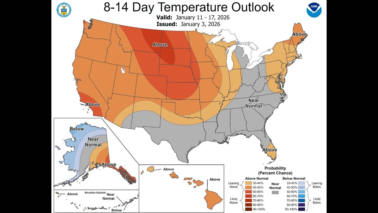
Forecast charts and the latest 8–14 day outlook indicate that above-average warmth will dominate the first half of the period, particularly across central and northern Alabama, before conditions normalize during the second half of January.
Midweek Warm Surge Brings Highs Into the 70s
Temperature projections from the Birmingham–Shuttlesworth area show a steady warming trend beginning early in the week. Afternoon highs are expected to climb from the upper 50s into the upper 60s and low 70s by Wednesday and Thursday, well above normal for early January.
Nighttime lows will also trend warmer, rising into the upper 50s to near 60 degrees, which is more typical of late March than mid-winter. This warm pattern is supported by a broad area of above-normal temperature probabilities extending across much of the central United States, including Alabama.
Dry Pattern Dominates Before Late-Week Changes
Most of the week is expected to remain dry and quiet, with stable conditions allowing temperatures to rise efficiently during the daytime. However, forecast guidance shows a cold front approaching late Thursday into Friday, bringing the return of showers and scattered storms across the region.
While the data does not currently indicate a high-end severe weather threat, the timing of the front suggests periods of rain and gusty winds, especially as warmer, moist air interacts with the advancing boundary.
Temperatures Fall Back to Seasonal Levels
Behind the cold front, temperatures are forecast to cool noticeably. Highs are expected to settle back into the upper 40s and 50s, with overnight lows dropping into the 30s, which is much closer to typical January conditions for Alabama.
This cooldown aligns with the Climate Prediction Center’s 8–14 day outlook, which places Alabama in a near-normal temperature zone from January 11 through January 17, signaling an end to the brief warm spell rather than a prolonged pattern change.
What This Means Going Forward
The data points to a classic winter temperature swing rather than a long-term shift. Residents across Alabama and the Deep South should enjoy the warm stretch but remain aware of late-week rain chances and a cooler, more seasonal feel returning next week.
As always, forecast confidence will increase as the cold front draws closer, and any changes to timing or rainfall coverage will become clearer in the coming days.
Stay weather-aware and check back with Waldron News for continued updates as this evolving pattern takes shape.