
Minnesota and Wisconsin Face Icy Travel Risk as Snow, Sleet, and Freezing Rain Target I-94 Corridor Sunday Afternoon
MINNESOTA – A short-lived but potentially hazardous winter weather setup is expected to impact parts of eastern Minnesota and western Wisconsin on Sunday afternoon, as a wintry mix of snow, sleet, and freezing rain develops along and north of the Interstate 94 corridor, creating slick and icy travel conditions.
Forecast data indicates that this will not be a long-duration storm, but even a brief period of ice accumulation could be enough to cause travel disruptions, especially on untreated roads, bridges, and elevated surfaces.
Timing and Areas Most Affected
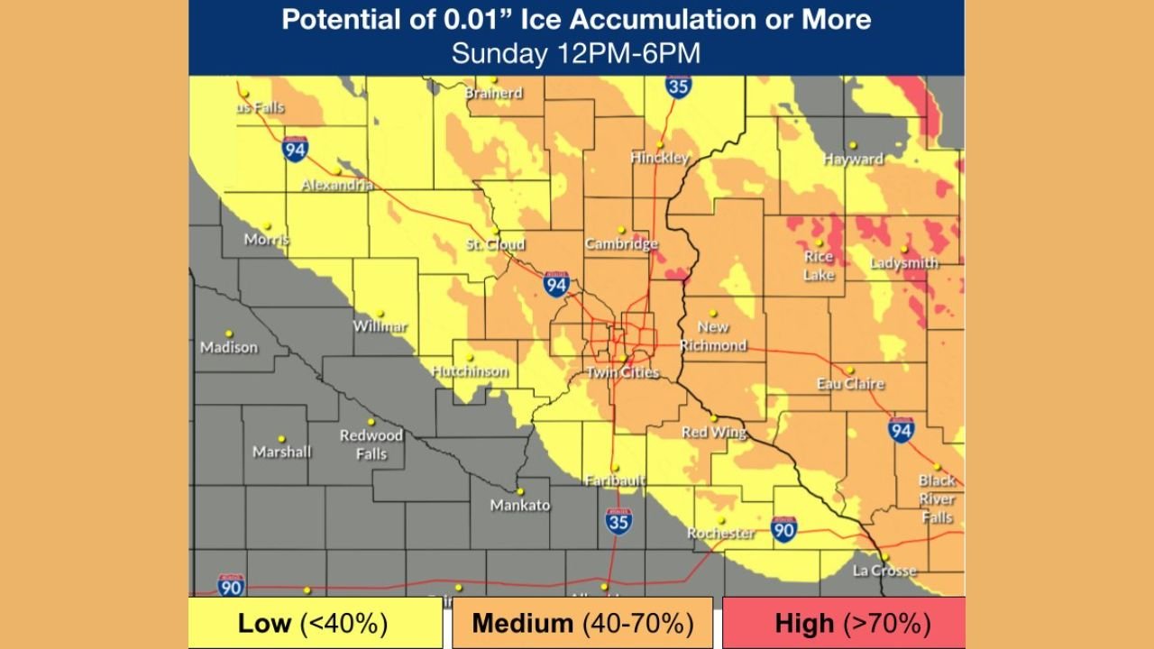
The highest risk window is expected between roughly 12 p.m. and 4 p.m. Sunday, when surface temperatures remain in the 20s to low 30s, allowing precipitation to freeze on contact. The most impacted areas include:
- Eastern Minnesota, including portions of the Twin Cities metro and counties north and east of I-94
- Western Wisconsin, especially areas near the Minnesota border and north of I-94
While precipitation may only last 2 to 4 hours at any one location, even light ice accretion can quickly lead to hazardous driving conditions.
Ice and Sleet Accumulation Outlook
Forecast guidance shows potential ice accumulation generally under 0.10 inches, but that amount is still sufficient to cause problems. Roads that are untreated or lightly traveled may become slick rapidly, particularly during the early afternoon period when freezing rain or sleet is most likely.
Snowfall amounts are expected to be minimal, with ice and sleet posing the primary concern. The precipitation type will vary by location, depending on subtle temperature differences near the surface.
Brief Improvement, Then Another Chance Tuesday
Conditions are expected to improve Sunday evening as precipitation exits the region. Monday looks dry with milder temperatures, helping to reduce lingering ice impacts.
However, another round of freezing rain is possible Tuesday, though forecast confidence is lower. Temperatures Tuesday may hover near or slightly above freezing, meaning the extent of impacts will depend on how quickly surfaces warm.
Travel Safety Concerns
With this event occurring during the afternoon, travel impacts could be noticeable even outside of traditional overnight freezing scenarios. Drivers are urged to:
- Reduce speed and allow extra stopping distance
- Be especially cautious on bridges, overpasses, and ramps
- Check local road conditions before traveling
- Avoid sudden braking or sharp turns on slick surfaces
Winter weather-related injuries and accidents most commonly occur during icy conditions, even when snowfall totals are low.
What to Expect Going Forward
Overall, this is a high-impact, low-duration winter event, where timing and surface temperatures matter more than total precipitation amounts. Residents in both Minnesota and Wisconsin should remain alert Sunday afternoon, particularly if travel along the I-94 corridor is necessary.
Stay with Waldron News for continued updates as newer forecasts refine timing, precipitation type, and the potential for additional impacts early next week.