
California Santa Cruz County and San Mateo County Under Tornado Warning as Possible Waterspout Threatens to Move Ashore Along Central Coast
CALIFORNIA — A Tornado Warning was issued for parts of Santa Cruz County and San Mateo County on Monday afternoon as meteorologists tracked a possible waterspout moving toward the Central California coastline, an unusual but potentially dangerous weather scenario for the region.
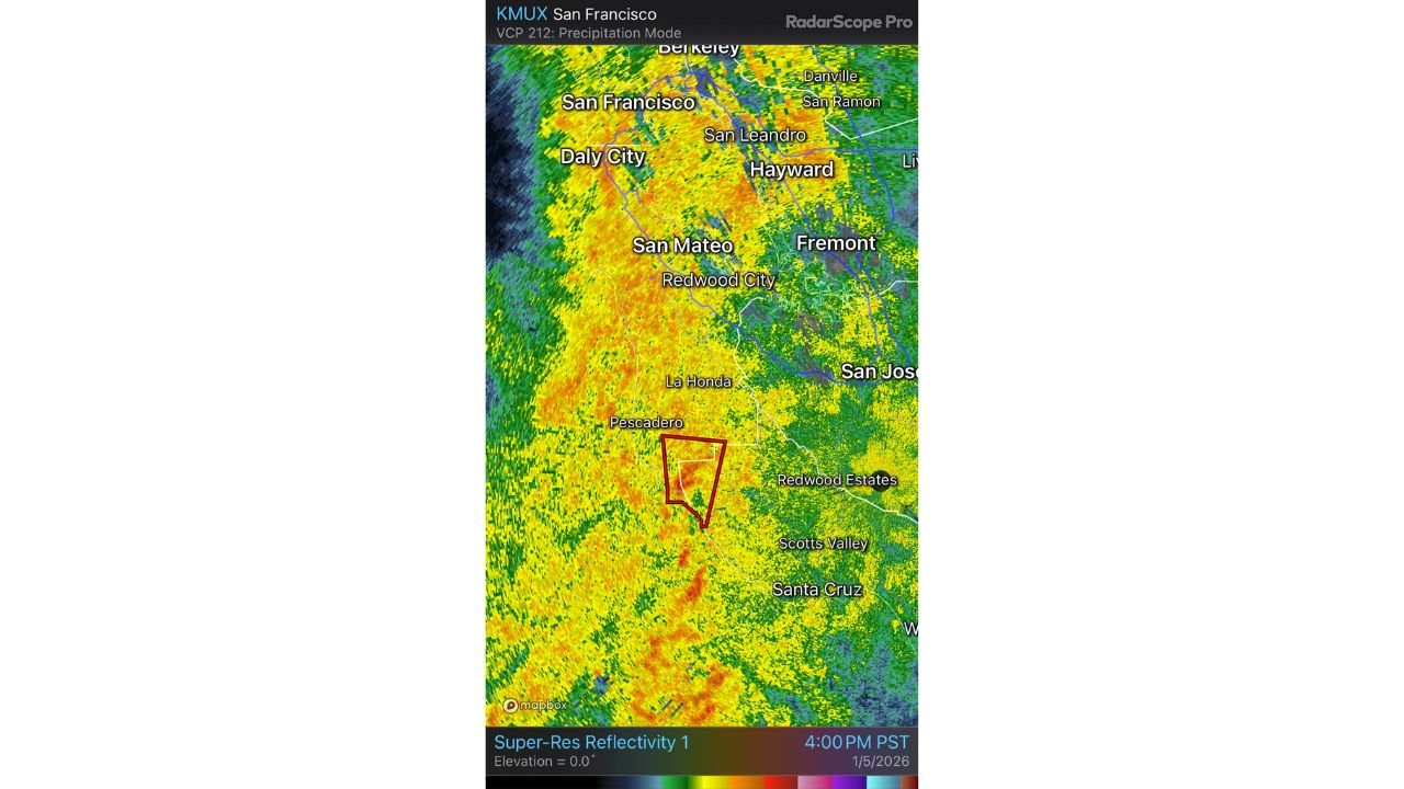
According to radar imagery and National Weather Service alerts, rotation was detected offshore and near the coast, prompting forecasters to warn that a waterspout could briefly move onshore and behave like a weak tornado. The warning area includes coastal and inland locations near Pescadero, La Honda, Scotts Valley, and parts of southern San Mateo County.
Radar Detects Rotation Near the Coast
High-resolution radar data from the San Francisco Bay Area showed a narrow but well-defined area of rotation, highlighted by the warning polygon just inland from the coast. The circulation appeared embedded within a strong Pacific storm system producing heavy rain and gusty winds across the region.
Meteorologists noted that while California tornadoes are rare, waterspouts transitioning onto land are the most common way tornado warnings occur along the state’s coastline during winter storms.
Why Waterspouts Can Trigger Tornado Warnings in California
Waterspouts form over water but can retain rotation as they move inland, briefly producing tornado-like winds. These events are typically weaker than Great Plains tornadoes, but they can still cause localized damage, including:
- Downed trees or branches
- Damage to roofs or outbuildings
- Power outages
- Hazardous travel conditions
Because visibility is often reduced by heavy rain, residents may not see the circulation before it reaches land.
Areas Most at Risk
The warning specifically targeted southern San Mateo County and northern Santa Cruz County, including rural and coastal communities. While population density in the immediate warning zone is relatively low, officials stressed that anyone within or near the warning area should take shelter immediately.
Even brief tornadoes or waterspouts can pose serious risks, especially in wooded or hilly terrain common along the Central Coast.
What Residents Should Do During the Warning
People in the warned area were advised to:
- Move indoors immediately
- Stay away from windows
- Take shelter in an interior room on the lowest floor
- Avoid coastal travel and marine activity
Drivers were urged not to attempt to outrun storms or drive through areas of poor visibility.
Rare but Not Unprecedented for the Bay Area
While tornado warnings are uncommon in California, they do occur during strong winter storms, particularly when cold air aloft and unstable conditions develop over coastal waters. The Central Coast has seen several similar events in past decades, usually short-lived but capable of producing damage.
Meteorologists emphasized that quick warnings and public response are critical, even when storms are brief.
Warning Timing and Ongoing Monitoring
The Tornado Warning was issued during the late afternoon hours as radar signatures intensified. Forecasters continued to monitor the storm closely to determine whether the circulation weakened offshore or persisted inland.
Residents were urged to stay alert for additional warnings or updates as the storm system moved through the region.
For real-time weather alerts, storm analysis, and breaking coverage of rare California weather events, continue following updates from WaldronNews.com.