
Texas Rain Returns to North and Central Texas Wednesday Night as Cooler Weekend Weather Follows Warm, Dry Start to January
TEXAS — After a warm and dry start to the week across North and Central Texas, forecast data shows rain chances returning Wednesday night through early Friday, followed by a noticeable cooldown heading into the weekend, according to guidance from the National Weather Service in Fort Worth.
The overall pattern points to a low-impact rain event, with scattered showers and a few storms possible, but no severe weather is expected. The more significant change arrives late Friday and over the weekend, when a cold front ushers in cooler temperatures, especially at night.
Rain Chances Increase Wednesday Night Into Thursday
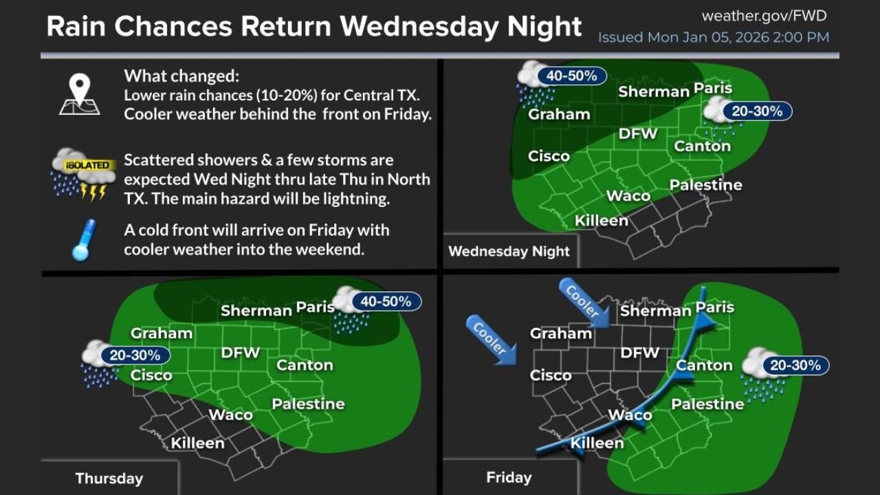
Forecast maps indicate rain chances expanding across much of North and Central Texas beginning Wednesday night, with the highest coverage expected overnight and into Thursday.
- Rain probabilities range from 40–50% across parts of North Texas, including areas near DFW, Sherman, Paris, and Graham
- Lower chances of 20–30% are shown farther south and west, including Cisco, Canton, and Palestine
- Showers may linger into early Friday, especially east of Interstate 35
While a few thunderstorms are possible, meteorologists note that the primary hazard will be lightning, not damaging winds or tornadoes.
Why Severe Weather Is Not Expected
Despite the presence of a few storms, atmospheric conditions do not support severe weather development. Forecast data shows limited instability and weak forcing, keeping storm intensity in check.
Forecasters emphasize that this setup is typical of a cool-season rain event, producing beneficial rainfall without the hazards associated with springtime storms.
Cold Front Brings Cooler Weather Friday and This Weekend
A cold front is expected to move through Texas on Friday, pushing rain east and allowing cooler air to settle in for the weekend.
Daytime highs are forecast to fall into the mid to upper 50s on Saturday, with overnight lows dropping into the upper 20s to mid-30s by Saturday night across North Texas.
By Sunday:
- Highs remain in the low to mid-50s
- Overnight temperatures again dip near or below freezing in some locations
The cooler air mass will feel noticeably different compared to the mild conditions earlier in the week.
What This Means for Residents
For most Texans, this pattern brings welcome rainfall without significant weather disruptions. However, the cooler weekend temperatures mean residents should prepare for:
- Chilly nights, especially Saturday and Sunday nights
- Potential impacts to pets, plants, and exposed pipes in colder-prone areas
- Slick roads during rain periods, particularly overnight
Meteorologists remind residents that even non-severe storms can still produce brief travel issues during heavier downpours.
Looking Ahead
Once the cold front passes, conditions are expected to turn drier but cooler heading into the second half of the weekend. No additional widespread rain or severe weather signals are evident immediately after this system.
Residents across North and Central Texas are encouraged to stay weather-aware midweek and prepare for colder temperatures by the weekend.
For continued local forecast updates, regional weather analysis, and week-ahead outlooks, follow WaldronNews.com.