
Washington, Oregon, Idaho, Montana, and Wyoming Face Widespread Mountain Snow as Pacific Storm Targets Cascades, Olympics, and Rockies Through Thursday
UNITED STATES — A Pacific storm system is set to deliver widespread snowfall across the western United States this week, with the greatest impacts expected in the Olympic Mountains, Cascade Range, and the Northern to Central Rockies across Washington, Oregon, Idaho, Montana, Wyoming, and parts of Utah and Colorado, according to the latest snowfall forecasts.
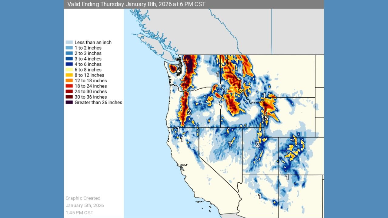
Forecast maps valid through Thursday evening show significant mountain snow accumulations, especially at higher elevations, as moist Pacific air is forced upslope into major mountain ranges. Lower elevations will see lighter totals, but travel impacts are likely in mountain corridors and passes.
Heaviest Snow Focused on Cascades, Olympics, and Northern Rockies
Snowfall projections indicate the most intense accumulations will occur in:
- The Olympic Mountains and Cascade Range of Washington, where several locations could receive 12 to 24 inches of snow, with isolated higher totals in favored terrain
- The Cascade Range of Oregon, particularly central and northern sections, with 8 to 18 inches possible at higher elevations
- The Northern Rockies of Idaho and western Montana, where 10 to 20 inches of snow is forecast in mountain zones
Snow bands appear persistent in these regions, increasing confidence in impactful totals rather than brief, light snowfall.
Central Rockies Also See Accumulating Snow
Farther inland, the storm is expected to bring accumulating snow to portions of the Central Rockies, including:
- Western Wyoming, where mountain totals of 6 to 12 inches are likely
- Northern Utah and western Colorado, where lighter but still impactful snowfall of 3 to 8 inches may occur in higher terrain
While totals here are lower than in the Cascades, cold temperatures and steady snowfall could still lead to slick travel conditions.
Lower Elevations See Lighter Totals
Outside of the mountains, many valleys and lower-elevation areas are forecast to receive less than an inch to a few inches of snow, with precipitation often falling as rain at the lowest elevations, especially along the West Coast.
However, even modest snow at higher elevations can significantly impact travel due to elevation changes along highways and mountain passes.
Travel Impacts Likely Through Thursday
With snow continuing through midweek, hazardous travel conditions are expected in mountain areas, including:
- Snow-covered and icy roads
- Reduced visibility during heavier snow bands
- Potential chain requirements or temporary pass restrictions
Drivers traveling through mountain routes such as Cascade passes or Rocky Mountain corridors should prepare for winter driving conditions and allow extra time.
What This Pattern Signals
This storm represents a more active Pacific pattern, delivering beneficial snowpack to western mountains after periods of uneven winter precipitation. While snowfall is welcome for water supply, the immediate concern remains travel safety and rapidly changing conditions in higher terrain.
Snow is expected to gradually taper late Thursday as the system moves east and weakens.
For continued regional snowfall updates, mountain travel impacts, and storm tracking, stay with WaldronNews.com.