
New York, Pennsylvania, New Jersey, Massachusetts, Vermont, New Hampshire, and Maine Face Mixed Winter Storm as Strong System Brings Rain, Ice, and Snow Sunday
UNITED STATES — After several weaker systems earlier this week, a stronger and more organized storm system is expected to move through the Northeast on Sunday, bringing a wide range of hazardous weather conditions across multiple states. Forecast data shows a sharp north–south temperature contrast, setting the stage for warm rain in the Mid-Atlantic, cold rain in southern New England, and a dangerous mix of snow, sleet, and freezing rain across northern New England.
Storm Timing and Overall Setup
The system is forecast to strengthen early Sunday morning as it moves northeast from the Mid-Atlantic into New England. Southerly winds ahead of the storm will push milder air northward, while colder air remains locked in place across northern areas. This clash of air masses is expected to create multiple precipitation types over relatively short distances, increasing the risk for travel disruptions and localized icing.
Mid-Atlantic: Warm Rain Dominates
New Jersey and eastern Pennsylvania are expected to remain mostly on the warm side of the system. Temperatures here should stay above freezing, allowing precipitation to fall mainly as steady rain.
- Periods of moderate to heavy rain are possible.
- Ponding on roadways and reduced visibility may affect travel.
- Snow is unlikely except at the highest elevations far inland.
Southern New England: Cold Rain and Slushy Transitions
Massachusetts, particularly central and eastern portions, is expected to see cold rain for much of the event. However, temperatures will hover close to freezing at times, especially during the early morning hours.
- Some locations could briefly mix with wet snow or sleet, mainly inland.
- Accumulation is expected to be limited, but slushy surfaces are possible.
- Coastal areas should remain mostly rain.
Northern New England: Ice and Snow Threat Increases
The most hazardous conditions are expected across Vermont, New Hampshire, and Maine, where colder air will be more firmly entrenched.
- Freezing rain and sleet are possible in valleys and lower elevations.
- Snowfall is likely at higher elevations and farther north.
- Even light icing could create dangerous travel conditions, especially on untreated roads and elevated surfaces.
Forecast models suggest highly variable snow and ice totals, depending on how quickly warm air pushes north and how long surface temperatures remain below freezing.
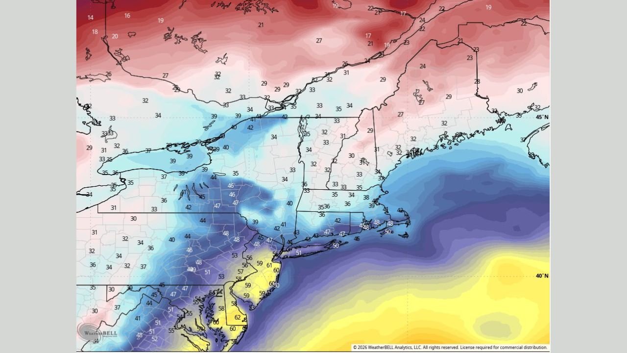
Temperature Contrast Highlights Storm Impact
Temperature guidance shows a dramatic gradient across the region:
- 40s to near 50°F in parts of New Jersey and southern Pennsylvania
- Low to mid-30s across Massachusetts
- Upper 20s to low 30s across northern New England
This sharp contrast explains why precipitation types will change rapidly across state lines.
Travel and Safety Considerations
Residents across the Northeast should prepare for rapidly changing road conditions, particularly Sunday morning into early afternoon.
- Allow extra travel time.
- Monitor local advisories for freezing rain and winter weather alerts.
- Be prepared for power outages in areas that experience icing.
Looking Ahead
Once the storm exits Sunday night, colder air is expected to settle back into the region. Any lingering moisture may refreeze, especially across northern areas, prolonging hazardous conditions into early Monday.
Stay weather-aware and continue to follow updates as this system approaches. For ongoing regional weather coverage and updates, visit WaldronNews.com.