
Kentucky, Tennessee, West Virginia, Virginia, and Pennsylvania Face Heavy Rain Threat as NOAA Issues Day 3–7 U.S. Hazards Outlook Through January 13
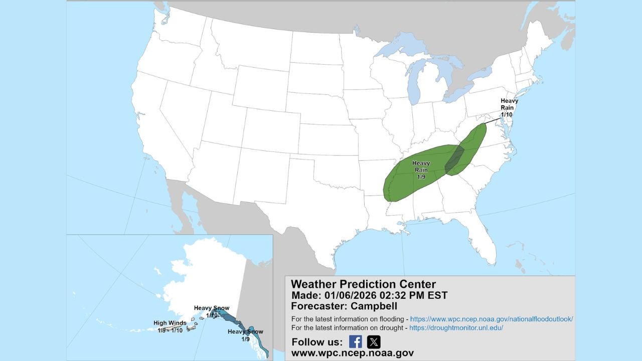
UNITED STATES — A new Day 3–7 U.S. Hazards Outlook issued by NOAA’s Weather Prediction Center highlights a developing stretch of hazardous weather across multiple regions of the country between January 9 and January 13, with the most significant concern centered on heavy rainfall across parts of the Ohio Valley, Tennessee Valley, and Mid-Atlantic, along with winter hazards continuing in Alaska.
According to the latest outlook, a slow-moving and moisture-rich storm system is expected to track eastward, bringing periods of heavy rain that could increase the risk of flooding, especially in areas that have already experienced recent rainfall.
Heavy Rain Focused From the Tennessee Valley Into the Mid-Atlantic
Forecast guidance shows a swath of heavy rain developing on January 9, stretching from central Tennessee and Kentucky northeastward through West Virginia, Virginia, Maryland, and into parts of Pennsylvania and the Mid-Atlantic.
This setup raises concerns for:
- Localized flooding, especially in low-lying and poor-drainage areas
- Rapid rises on small streams and creeks
- Urban flooding, where rain falls over a short period
Soils across portions of this region are already moderately saturated, which could worsen runoff issues if rainfall totals increase or storms train over the same locations.
Timing and Evolution of the System
The Weather Prediction Center indicates that:
- The heaviest rain threat emerges Friday, January 9
- Rain may continue eastward into the central and northern Mid-Atlantic on January 10
- Cooler air wrapping in behind the system could eventually transition precipitation in higher elevations, though rain remains the primary concern during this period
Residents across the impacted states should monitor later forecasts, as even small changes in storm track could shift the axis of heaviest rainfall.
Alaska Continues to See Winter Hazards
While the Lower 48 deals with rain threats, Alaska remains under multiple winter hazards during the same outlook period.
The updated map highlights:
- Heavy snow across southern and coastal portions of Alaska
- High winds, particularly near the Aleutians and coastal zones
- Continued impacts to travel and infrastructure due to blowing snow and reduced visibility
These hazards may persist or expand as additional systems move through the region.
What to Watch in the Days Ahead
As the January 9–13 period approaches, forecasters will refine:
- Exact rainfall totals and flooding risk zones
- Potential upgrades to flood outlooks or watches
- Any added winter weather threats in higher terrain
People living in Kentucky, Tennessee, West Virginia, Virginia, Pennsylvania, and surrounding states are encouraged to stay weather-aware, especially if travel or outdoor plans are scheduled during the weekend.
Stay with Waldron News for continued updates, forecast refinements, and impact-focused coverage as this developing weather pattern moves closer.