
Maine and New Hampshire Brace for Slippery Morning Commute as Snow and Ice Spread North to South Overnight Under Winter Weather Advisories
NEW HAMPSHIRE — Another round of winter weather is moving into northern New England tonight, bringing snow to northern areas and mixed precipitation with ice farther south, according to updated forecasts from the National Weather Service. Winter Weather Advisories go into effect beginning at 7 p.m., with conditions expected to worsen overnight and impact the Wednesday morning commute across both states.
Forecasters warn that residents should prepare for slick roads, reduced visibility, and hazardous travel conditions, especially during early morning hours.
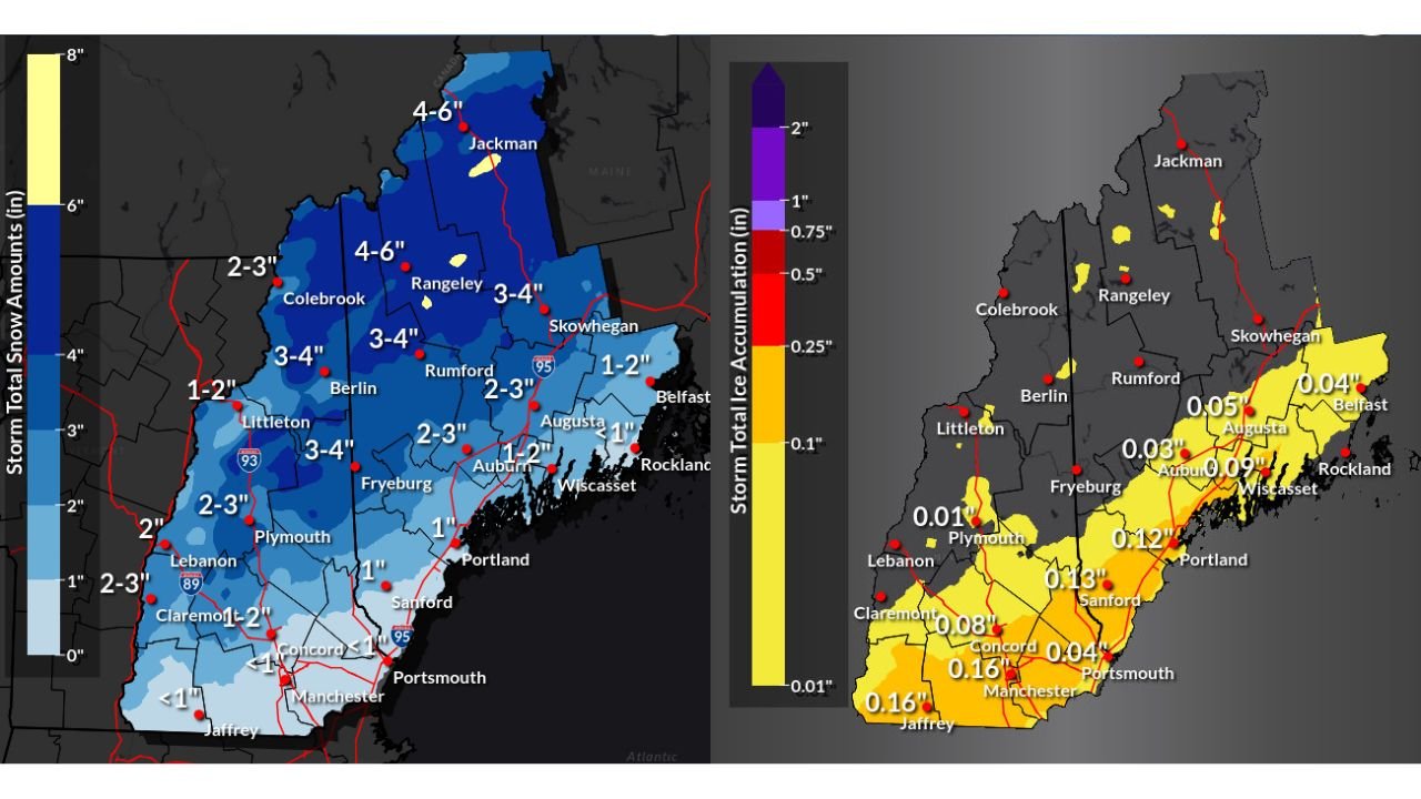
Snowfall Totals Higher in Northern Maine and the Mountains
Forecast maps show the heaviest snowfall concentrated across northern and western Maine, particularly in higher terrain.
- Northern and western Maine (including Rangeley, Jackman, Berlin, and Rumford):
3 to 6 inches of snow, with localized higher amounts in the mountains. - Central Maine (Skowhegan, Fryeburg, Colebrook):
2 to 4 inches of snow. - Southern Maine and coastal areas (Portland, Augusta, Belfast, Rockland):
1 to 2 inches, with snow mixing with sleet or freezing rain closer to the coast. - Southern New Hampshire (Manchester, Concord, Jaffrey):
Less than 1 inch of snow, but ice will be the primary concern.
Snow will taper off by late Wednesday morning, but untreated roads may remain slippery into the afternoon.
Ice Accumulation Raises Travel and Power Concerns in Southern Areas
While snowfall amounts are lower in southern zones, ice accumulation is expected to create greater hazards, particularly across southern New Hampshire and southern Maine.
- Southern New Hampshire and coastal Maine:
0.10 to 0.16 inches of ice possible in spots. - Central Maine:
Generally 0.03 to 0.09 inches of ice. - Northern Maine:
Minimal ice accumulation expected.
Even light ice buildup can cause dangerous driving conditions, especially on bridges, overpasses, and secondary roads. Localized slick power lines and tree branches are also possible where ice totals approach a tenth of an inch.
Timing: When Conditions Will Be Worst
- After 7 p.m. Tuesday: Precipitation spreads in from southwest to northeast.
- Late night to early Wednesday morning: Peak impacts, including snow-covered roads and icy surfaces.
- Wednesday mid-morning: Precipitation tapers off, but lingering slick spots remain.
Emergency managers emphasize that the Wednesday morning commute will be the most impacted period, particularly for school buses and early commuters.
What Residents Should Do Now
Officials urge residents to take basic precautions ahead of the storm:
- Allow extra travel time Wednesday morning
- Reduce speed and increase following distance
- Avoid sudden braking on icy roads
- Check local road conditions before heading out
- Ensure vehicles are equipped with winter safety supplies
Those traveling overnight or early Wednesday should be especially cautious in rural and higher-elevation areas.
More Winter Weather Likely This Week
Forecasters note that this system is part of a busy winter pattern, with additional disturbances possible later this week. Residents across Maine and New Hampshire are encouraged to stay alert for further advisories or updates as conditions evolve.
Have you experienced slippery roads or school delays from this storm? Share your local conditions and stay connected with the latest New England weather updates at WaldronNews.com.