
Missouri and Illinois Face Conditional Tornado Risk Thursday Evening as Instability Increases Ahead of Developing Storm Line
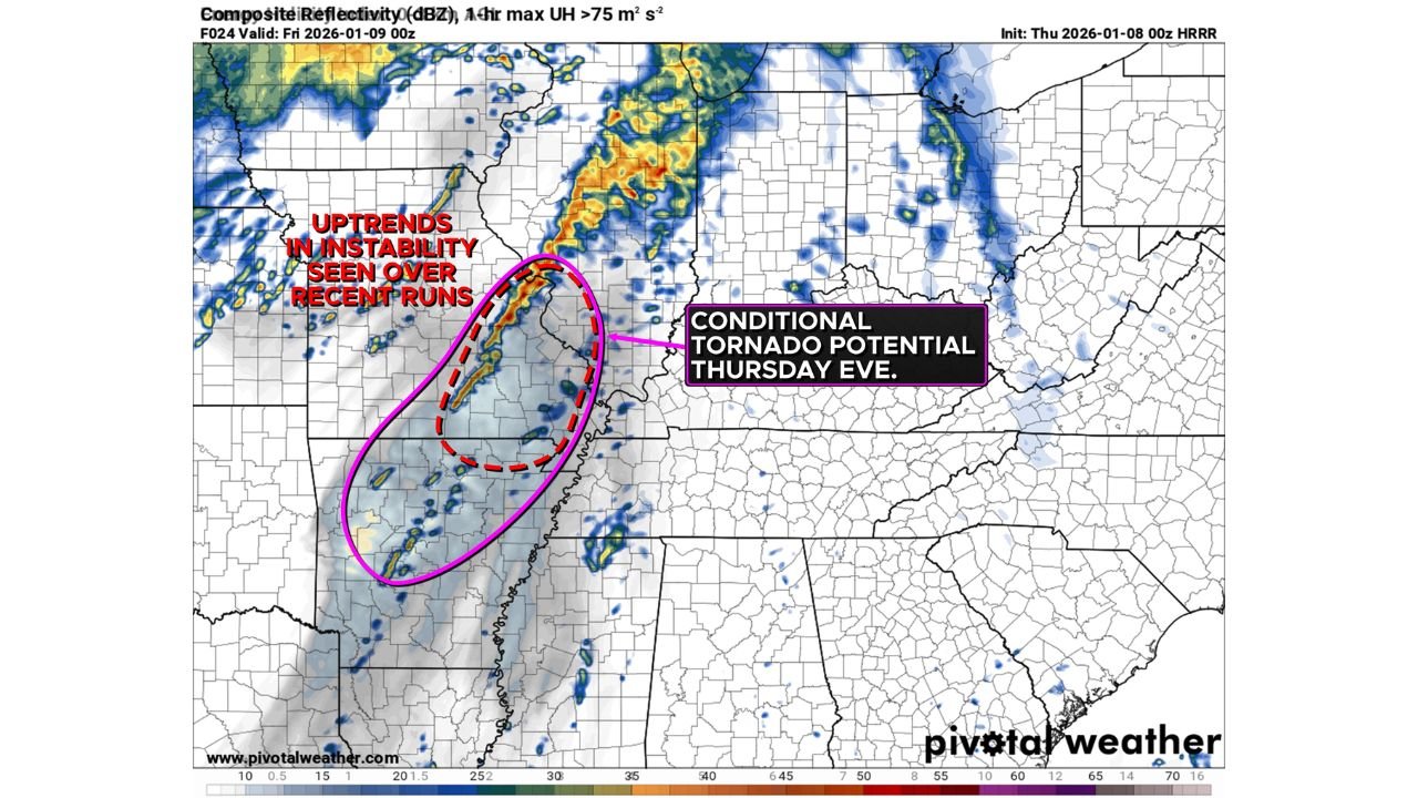
MISSOURI — Parts of Missouri and western Illinois are being closely monitored for a conditional severe weather threat Thursday afternoon into Thursday evening, as forecasters observe uptrending atmospheric instability ahead of a developing storm system. While the overall setup remains marginal, recent model trends suggest the environment may become just supportive enough for a low-end tornado risk, along with large hail and damaging winds.
Forecast guidance shows instability increasing across central and eastern Missouri during the afternoon, with the potential extending into western Illinois by evening. The most favorable window appears to be late afternoon through early nighttime hours, when storms attempt to organize along and ahead of a developing line of showers and thunderstorms.
Why the Tornado Risk Is Being Watched Closely
Even though instability values are not particularly high for January standards, wind shear profiles remain favorable, and recent high-resolution model runs indicate slightly stronger updraft potential compared to earlier forecasts. This has prompted forecasters to highlight a “conditional tornado potential”, meaning tornado development is possible if storms can mature and remain organized.
One limiting factor is that the strongest upper-level lift is displaced from the warm sector, which could prevent storms from fully strengthening. However, if storms are able to tap into localized instability pockets, isolated tornadoes cannot be ruled out, especially within any discrete or semi-discrete cells that form ahead of the main line.
Storm Development May Be Spotty but Impactful
Storm coverage is not expected to be widespread, and many areas may see little to no severe weather. That said, any storm that does successfully develop could quickly become severe. Hazards being monitored include:
- Isolated tornadoes, especially across central and eastern Missouri
- Large hail, potentially damaging to vehicles and structures
- Strong to locally damaging wind gusts, particularly within stronger storm cores
The risk gradually shifts eastward into western Illinois during the evening, though instability may weaken with time as storms move away from the most favorable environment.
Timing and Areas of Concern
- Thursday Afternoon: Increasing instability across Missouri
- Thursday Evening: Conditional tornado risk expands into western Illinois
- Late Evening: Storms weaken as instability decreases
Residents across the region are encouraged to remain weather-aware, especially if outdoor plans or evening travel are scheduled. While the threat is not guaranteed, the potential impacts could be serious where storms do intensify.
What Happens Next
Forecasters will continue to refine the outlook as newer data becomes available. Any upgrade in risk levels or the issuance of watches or warnings would depend on how quickly instability increases and how storms evolve during the day.
Stay connected with Waldron News for real-time updates, forecast changes, and any severe weather alerts issued for Missouri and Illinois. If storms develop, we’ll provide timely coverage to help you stay informed and prepared.