
New York, Pennsylvania, Ohio, and New England States Enter Key Mid-January Winter Weather Window as Jet Stream Signals Rising Storm Potential
UNITED STATES — Meteorologists are closely monitoring a developing large-scale weather pattern that could open the door to more active winter conditions across the Eastern United States later next week and into mid-January. While no specific storm system has formed yet, atmospheric signals indicate that conditions may soon become more favorable for winter weather development.
Long-Range Outlook Focuses on Pattern, Not Specific Storms
Current forecast maps extend more than a week into the future, meaning they are designed to highlight overall atmospheric trends, not exact storm tracks or snowfall amounts. At this range, computer models are known to be unreliable when it comes to surface-level storm details.
Forecasters emphasize that the lack of a clearly defined winter storm on long-range maps should not be interpreted as a sign that winter weather will be absent. Instead, it suggests that the atmosphere is still in the early stages of organizing.
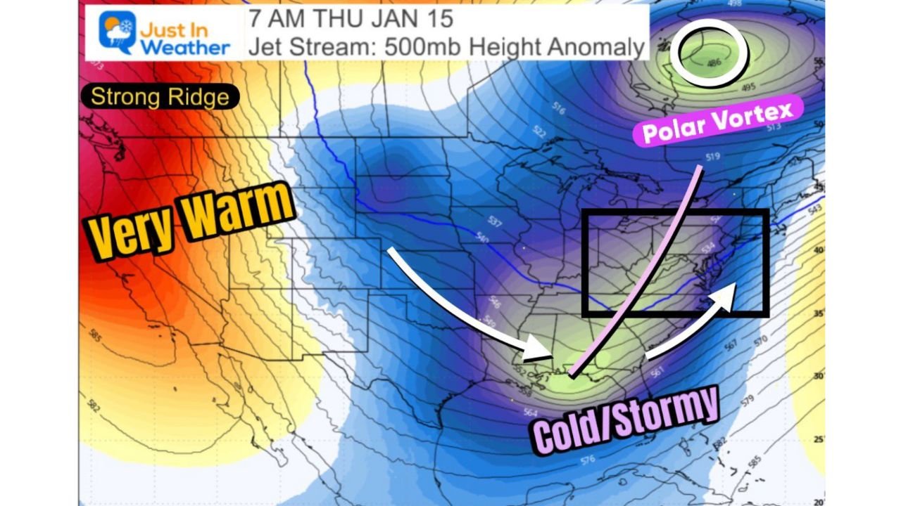
Jet Stream Setup Becoming More Favorable for Eastern U.S. Activity
Upper-level data shows a strengthening ridge of warmer air building across the western United States while colder air begins to press southward into the central and eastern portions of the country. This configuration places the Eastern U.S. beneath a more energized jet stream — a setup that frequently supports storm development during winter.
When cold air availability overlaps with an active jet stream, the probability of winter systems attempting to form increases, even if timing and placement remain uncertain.
Mid-January Marks a Historically Active Snowfall Period
Climatology strongly supports heightened winter activity during the upcoming timeframe. In many parts of the Eastern United States, roughly 75 percent of seasonal snowfall typically occurs between January 15 and February 28.
As the region approaches this climatological peak, even modest atmospheric shifts can result in notable winter weather events.
What Forecasters Are Watching Over the Next 7–10 Days
Meteorologists generally assess winter potential in stages:
- 1–2 weeks out: Identify favorable large-scale patterns
- Within 7 days: Increased confidence in storm potential
- Within 5 days: Realistic discussion of snow or ice threats
- Within 3 days: Higher confidence in impacts and totals
At present, the forecast remains in the pattern-recognition phase, but signals suggest movement toward a more active phase by late next week.
Why No Snow Maps Are Being Shown Yet
Experts caution against circulating early snowfall or storm-specific maps this far in advance. Experience shows that such graphics often change dramatically and can create unnecessary confusion. More meaningful and reliable winter forecasts typically emerge closer to the event window.
Bottom Line
While no winter storm is currently locked in, atmospheric conditions are trending toward a setup that historically supports winter weather in the Eastern United States. Confidence will increase as the forecast window shortens, and updates are expected as the pattern evolves.
For continued tracking, clear explanations, and timely updates as winter potential increases, stay connected with WaldronNews.com — and share your thoughts on what you’re watching as mid-January approaches.