
New York, Pennsylvania, West Virginia, Virginia, North Carolina, and Tennessee Face Elevated Heavy Snow Risk as CPC Flags January 17–23 Winter Window
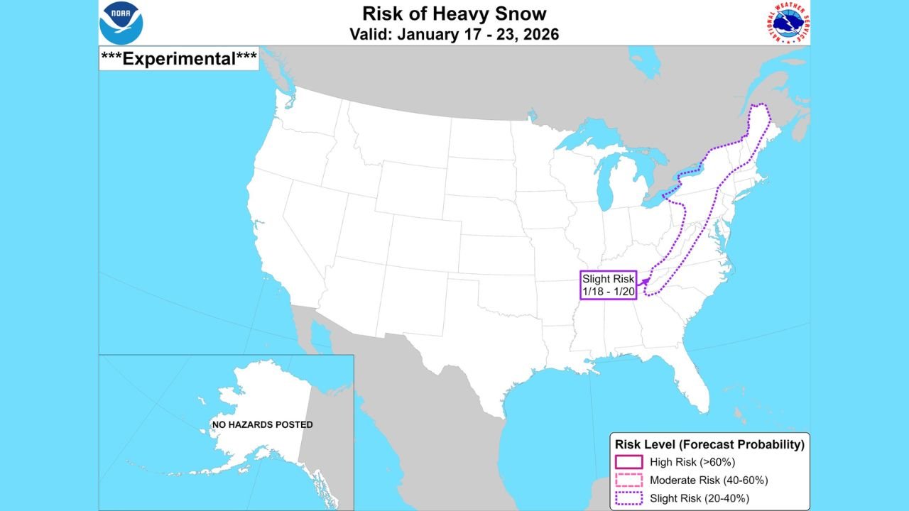
UNITED STATES — The Climate Prediction Center (CPC) has issued an experimental slight risk of heavy snowfall covering a broad corridor from the Northeast United States southward through the Appalachian region and into Northeast Tennessee, signaling increasing confidence that mid- to late January could feature one or more impactful winter weather systems. The risk window spans January 17 through January 23, with the highest concern centered around January 17–18.
What the CPC Slight Risk Means
A slight risk designation from the CPC represents a 20–40% probability of heavy snow occurring somewhere within the outlined corridor during the valid period. While this does not guarantee widespread snowfall, it highlights an environment that is becoming increasingly supportive of organized winter storms capable of producing disruptive accumulations.
The shaded corridor extends across:
- New York and Pennsylvania
- West Virginia
- Virginia
- North Carolina
- Northeast Tennessee
These areas sit along the climatologically favored Appalachian snow belt, where cold air damming, terrain enhancement, and coastal or inland storm tracks can significantly boost snowfall totals.
Multiple Storm Systems Under Review
Forecast guidance indicates more than one storm system could affect the eastern United States during this period.
- January 14–15:
An earlier system may bring wintry weather, particularly inland and at higher elevations, though confidence in heavy snow remains lower at this time. - January 17–18:
This is currently the most favored window for a more impactful event. Computer forecast models are showing stronger upper-level support, improved cold air availability, and better storm organization during this timeframe.
The CPC’s alignment with these model trends adds weight to the signal, even as uncertainty remains regarding exact storm tracks and precipitation types.
Why Confidence Is Growing — But Not Locked In
Ensemble guidance suggests a more favorable large-scale pattern, including repeated upper-level disturbances moving through the eastern United States. However, timing differences and storm-to-storm interactions could still shift snowfall north, south, or offshore.
Forecasters caution against focusing on individual model runs. Instead, the CPC outlook reflects broad agreement across many simulations, which is why the risk area has been outlined despite the experimental nature of the product.
Potential Impacts If Heavy Snow Develops
Should one or more storms fully materialize, impacts could include:
- Travel disruptions along the I-81 and I-95 corridors
- Power outages in higher-elevation Appalachian communities
- Hazardous road conditions across interior Northeast and Mid-Atlantic states
Exact locations of the heaviest snowfall will depend on storm track, thermal profiles, and cold air placement, all of which will become clearer closer to the event window.
Bottom Line
The January 17–23 period is emerging as a legitimate winter weather window, with January 17–18 standing out as the most likely timeframe for heavier snow somewhere from the Northeast through the central Appalachians into Northeast Tennessee. While nothing is guaranteed, the CPC’s involvement confirms that this threat is more than routine model noise.
Residents across the affected states should stay alert for forecast updates as confidence increases and details sharpen. Stay connected with Waldron for clear, no-hype winter weather coverage as this developing situation continues to evolve.