
Florida Braces for Major Cold Outbreak as Arctic Air Pushes Wind Chills Into the 20s Along the I-4 Corridor Late Next Week
FLORIDA — A significant cold air intrusion is increasingly likely to reach Florida by the end of next week, bringing the coldest conditions of the season and raising freeze concerns across central and northern parts of the state, including areas along and north of the Interstate 4 corridor. Forecast guidance shows this event peaking early Friday morning, when wind chills could dip into the 20s in parts of inland Florida.
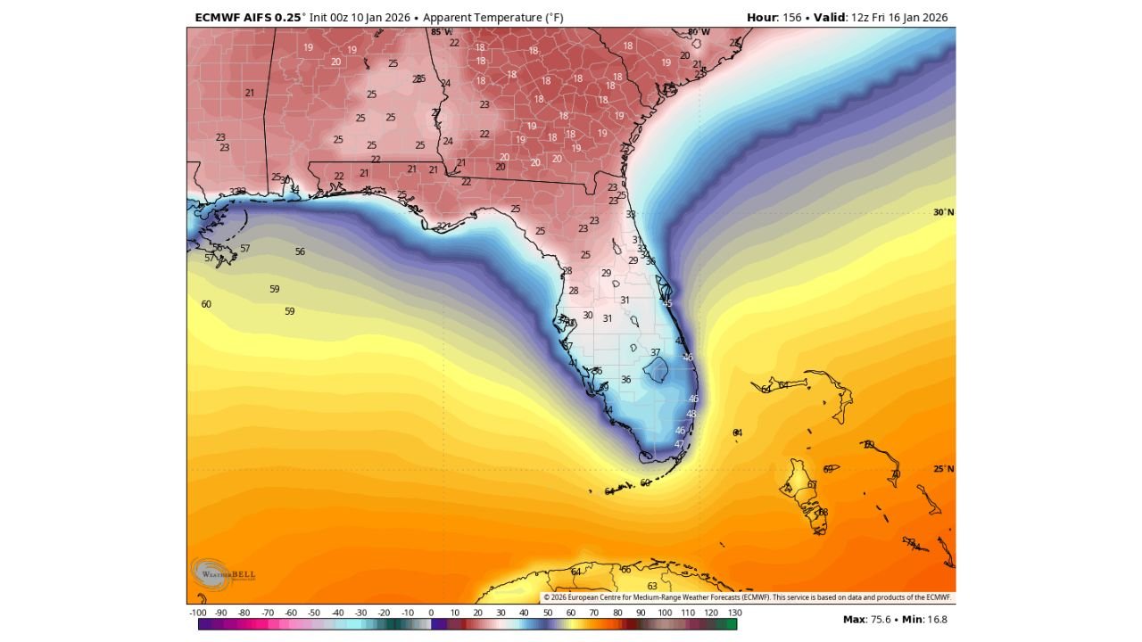
What the Forecast Data Is Showing
The latest ECMWF (European) AI forecast models indicate a sharp southward push of Arctic air behind a developing storm system over the Mid-Atlantic. Apparent temperature maps show a narrow but intense cold channel plunging down the Florida Peninsula, with the coldest wind chills focused inland rather than along the immediate coast.
Key signals from the data include:
- Wind chills in the upper 20s to low 30s across northern and central Florida
- Sub-freezing wind chills possible inland, especially north of Orlando
- Coastal areas staying milder, but still well below seasonal norms
The magnitude of this cold outbreak will depend heavily on how strong the Mid-Atlantic storm system becomes. A deeper, stronger low pressure system would allow colder air to penetrate farther south into Florida.
Freeze Concerns Along the I-4 Corridor
The I-4 corridor, which includes the Orlando metro area, sits near the southern edge of the highest freeze risk. While widespread hard freezes are not guaranteed at this time, radiational cooling combined with strong cold advection could allow temperatures to approach freezing in rural and inland locations.
Impacts may include:
- Cold stress for sensitive vegetation and citrus crops
- Hazardous conditions for those without adequate heating
- Unseasonably cold mornings for commuters and students
Urban cores may stay slightly warmer, but outlying areas could cool more efficiently overnight.
Why Confidence Is Growing — But Not Locked In
Forecasters note that Florida cold outbreaks of this nature are highly sensitive to storm track and timing. Even a small eastward shift in the Mid-Atlantic storm could keep the coldest air offshore. However, ensemble guidance increasingly supports the idea that a strong low pressure system will form, increasing confidence that some level of significant cold will reach Florida.
This is not a guaranteed worst-case scenario, but it is credible enough to monitor closely.
What Residents Should Do Now
With several days still remaining, this is the time for early preparation, not panic.
Recommended steps include:
- Monitor daily forecast updates as confidence increases
- Prepare plants, pets, and exposed pipes for cold conditions
- Plan for very cold early-morning conditions Friday
- Be cautious of misleading daytime warmth — the cold will peak overnight
Bottom Line
Florida is facing a potentially impactful cold snap late next week, with wind chills in the 20s possible inland and freeze concerns extending into central parts of the state. While details will evolve, this is shaping up to be one of the more notable cold shots of the winter season and warrants close attention in the days ahead.
Stay with Waldron News for continued updates as the forecast becomes clearer and confidence increases.