
New York Wind Advisory Targets Rochester, Buffalo, Niagara Falls, and Jamestown With 50 MPH Gusts From Saturday Night Through Sunday Afternoon
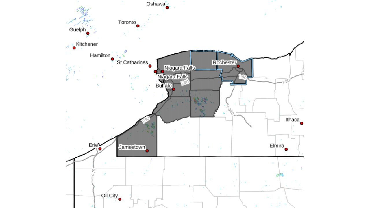
NEW YORK — A renewed burst of strong winter winds is set to impact large portions of western New York this weekend, as Wind Advisories have been issued from Rochester westward, including Buffalo, Niagara Falls, and Jamestown, according to the latest forecast data. The advisory period runs from 8 p.m. Saturday through 1 p.m. Sunday, with wind gusts potentially reaching up to 50 mph at times.
While these winds are not expected to match the peak gusts observed during Friday’s stronger system, meteorologists say they could still be powerful enough to cause isolated power outages, difficult travel, and scattered tree damage, especially in exposed and lakeshore communities.
Wind Advisory Coverage and Timing
The advisory area stretches across much of western New York, covering key population centers and travel corridors along and south of Lake Ontario and Lake Erie. Cities and surrounding counties under the advisory include:
- Rochester and nearby Finger Lakes counties
- Buffalo and the Niagara Frontier
- Niagara Falls and surrounding areas
- Jamestown and the western Southern Tier
The strongest winds are expected overnight Saturday into Sunday morning, when the pressure gradient tightens behind a departing weather system. Gusts could briefly approach 50 mph, particularly in open areas and along elevated terrain.
How This Compares to Friday’s Wind Event
Forecasters emphasize that this event will be weaker than Friday’s damaging wind gusts, which caused more widespread disruptions. However, the timing and persistence of the winds still pose concerns.
Even moderate-strength winter winds can stress trees already weakened by cold temperatures, snow loading, or saturated ground conditions. Power companies typically see sporadic outages during events like this, especially where tree limbs come into contact with overhead lines.
Travel and Infrastructure Impacts
Drivers across western New York should be prepared for sudden crosswinds, particularly on north–south roads and bridges. High-profile vehicles such as trucks, vans, and SUVs may experience handling difficulties, especially during peak gusts late Saturday night and early Sunday.
Residents are advised to:
- Secure loose outdoor items before Saturday evening
- Avoid parking vehicles near large trees
- Charge essential devices ahead of time in case of brief outages
A Persistent Pattern of Windy Winter Weather
This advisory is part of a longer-running pattern of active winter weather affecting the Great Lakes region. Frequent storm systems, tight pressure gradients, and cold air intrusions have combined to produce repeated rounds of strong winds across New York and neighboring states.
Meteorologists note that while calmer conditions are expected later Sunday, the overall winter pattern remains unsettled, with additional systems possible in the days ahead.
As always, residents across western New York should stay alert for updates overnight and be prepared for rapidly changing conditions.
What are you seeing where you live — strong gusts, flickering power, or travel issues? Share your local conditions and stay connected with Waldron News for continued weather coverage and updates throughout the weekend.