
Louisiana, Mississippi, Alabama, and Texas Face Rising Severe Storm Risk With Tornadoes and Damaging Winds Possible Into Evening
LOUISIANA — A developing severe weather setup is unfolding across parts of Texas, Louisiana, Mississippi, and Alabama, as the Storm Prediction Center warns that severe storm potential is expected to gradually increase from late afternoon into the early evening hours. While a widespread severe weather outbreak is not guaranteed, meteorologists say conditions are becoming increasingly favorable for isolated tornadoes, damaging wind gusts, and pockets of large hail across the region.
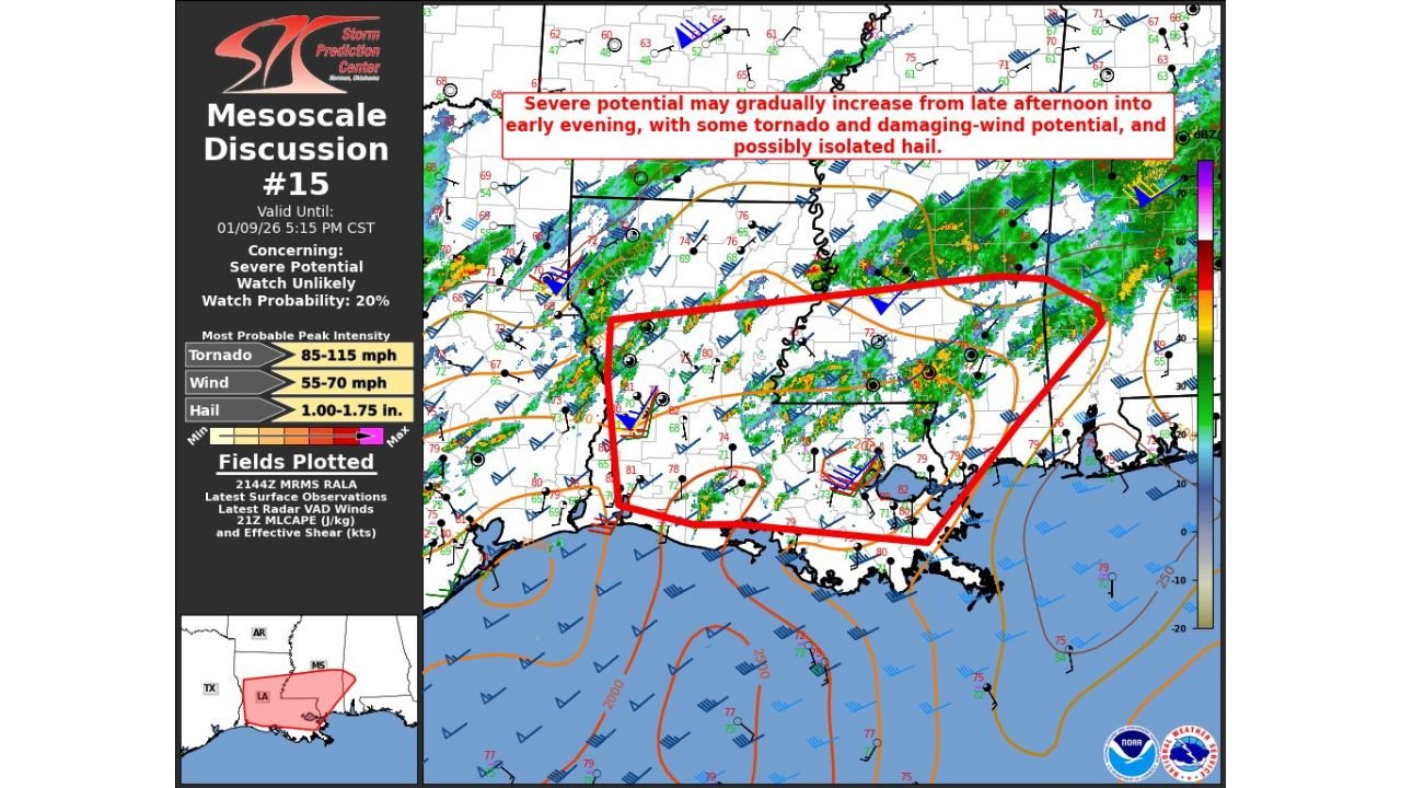
According to SPC Mesoscale Discussion #0015, storms are organizing along and ahead of a frontal boundary stretching across the central and eastern Gulf Coast, with a 20% probability of a severe weather watch issuance as the environment continues to evolve.
Where the Greatest Risk Is Developing
The highlighted risk area covers a broad swath of the central Gulf Coast, including:
- Southern and central Louisiana
- Southern Mississippi
- Southern Alabama
- Far eastern Texas near the Gulf Coast
Radar imagery shows clusters of thunderstorms becoming more organized, with storms increasingly capable of producing strong wind gusts and brief tornadoes, especially where storms interact with boundaries and localized wind shear is maximized.
Tornadoes, Damaging Winds, and Isolated Hail Possible
While the overall severe risk remains conditional, forecasters note that any storm that intensifies could quickly become dangerous. Based on SPC guidance, the most likely hazards include:
- Tornadoes, potentially brief but capable of producing localized damage
- Damaging straight-line winds in the 55–70 mph range
- Isolated hail, with some storms capable of producing hail up to 1–1.75 inches
Storms are expected to strengthen as they tap into warm, humid Gulf air, combined with increasing wind shear during the late afternoon and early evening timeframe.
Why Meteorologists Are Watching This Closely
Surface observations indicate rich low-level moisture, temperatures climbing into the upper 70s and lower 80s, and strengthening winds aloft, all ingredients that support storm intensification. Even though storm coverage may remain scattered, any discrete storm that develops could rotate, raising the tornado threat.
Because the severe risk is not expected to be widespread, a watch may not be immediately issued, but conditions will be closely monitored through the evening as storms evolve.
What Residents Should Do
People across southern Texas, Louisiana, Mississippi, and Alabama are urged to stay weather-aware through the evening hours:
- Monitor local weather alerts and radar
- Have a way to receive warnings, especially after sunset
- Review tornado safety plans, particularly in mobile homes or vulnerable structures
- Be prepared for sudden power outages or downed trees
This setup highlights how severe weather can rapidly intensify along the Gulf Coast, even outside of peak spring storm season.
If storms begin to strengthen near your area, act quickly and take warnings seriously. Stay with Waldron News for continued updates as meteorologists track this evolving severe weather threat across the Gulf Coast states.