
Midwest and Southeast Winter Storm Chances Hinge on Jet Stream Phasing as Late-Week and Weekend Snow Potential Remains Uncertain
UNITED STATES — The potential for impactful winter weather from Wednesday into Thursday — and possibly again next weekend — will depend heavily on how multiple jet stream disturbances interact, according to the latest synoptic-scale forecast analysis. While the pattern shows clear signs of energy in both the northern and southern jet streams, forecasters stress that timing and alignment will determine whether this becomes a meaningful snow event or a mostly uneventful system.
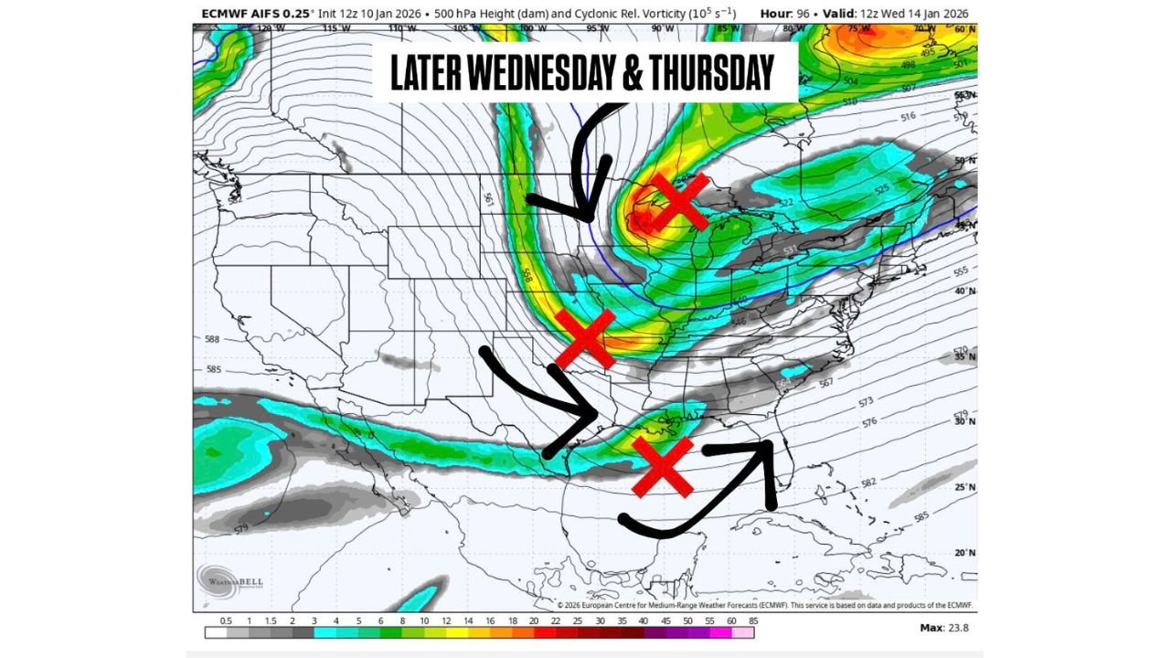
Current guidance shows two separate pieces of energy in the northern jet stream and one in the southern jet, all of which could influence storm development late Wednesday into Thursday. Whether these features phase together — meaning they merge into a stronger, more organized system — remains the critical question.
Why Jet Stream Phasing Matters So Much
When northern and southern jet energy phase strongly and at the right location, storms tend to deepen, pull colder air farther south, and generate broader areas of accumulating snowfall. In contrast, if the energy remains flat, disorganized, or consolidates too far east, the system weakens, and snow potential drops sharply.
In the weaker scenario, impacts would likely be limited to:
- Light snow
- Rain or wet snow
- Mixed precipitation
- Minimal accumulation
This distinction is especially important for areas near the rain-snow transition zone, where small shifts in storm track or temperature profiles can dramatically change outcomes.
Late Wednesday Into Thursday: First Window to Watch
Forecast models show the first opportunity for winter weather developing late Wednesday into Thursday, driven by the interaction of jet energy across the central U.S. If phasing occurs earlier and farther southwest, confidence in meaningful snowfall increases, particularly across portions of the Midwest and interior regions.
However, if the system stays separated or phases late:
- Snow would be more scattered
- Accumulations would be limited
- Rain or mixed precipitation becomes more likely south and east
At this time, nothing is locked in, and forecasters caution against focusing on specific snowfall totals.
Next Weekend: A Second, Conditional Winter Threat
Looking ahead, forecast guidance also hints at a follow-up threat next weekend, again tied to whether northern and southern stream energy can link up. This secondary setup shows potential, but it remains even more uncertain than the midweek system.
While the pattern supports winter weather development, confidence is low, and outcomes range from:
- A more organized winter storm
- A weaker system with limited impacts
- Or no significant event at all
Bottom Line: Potential Exists, But Details Are Far From Set
Meteorologists emphasize that this is a classic high-uncertainty winter pattern, where confidence improves only as jet stream details come into focus. The ingredients are present, but how they come together will decide everything.
For now:
- Yes, winter weather potential exists
- No, nothing is guaranteed
- Forecast clarity should improve over the next few days
Residents across the Midwest and Southeast should stay alert to forecast updates, especially if travel plans are coming up later this week or next weekend.
Stay with Waldron News as we continue tracking these evolving jet stream interactions and provide clearer guidance as confidence increases.