
Illinois and Indiana Brace for Prolonged Lake-Effect Snow Event as Bands Target Chicago Metro and Northwest Indiana
CHICAGO, ILLINOIS — Forecast data from multiple high-resolution models indicates a prolonged lake-effect snow event is increasingly likely from Wednesday morning into early Thursday, with the greatest impacts expected along and just south of Lake Michigan, particularly across northwest Indiana and portions of northeast Illinois, including the Chicago metro area.
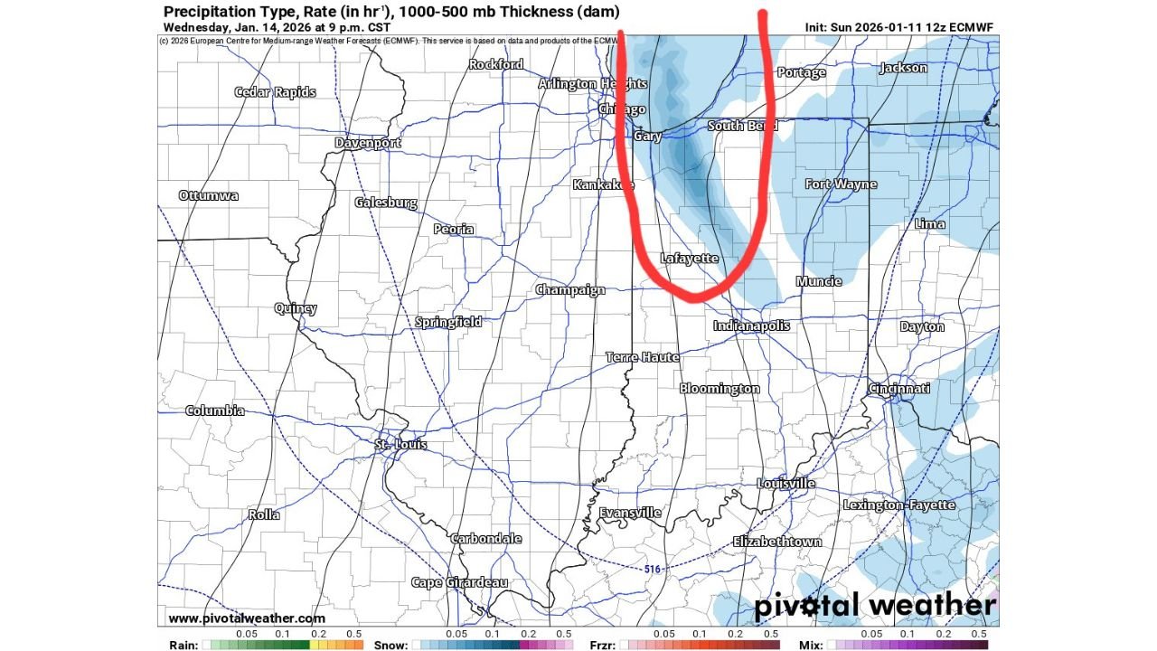
Meteorologists analyzing precipitation type, snowfall rates, and atmospheric thickness values show persistent snow bands developing as colder air flows over the relatively warmer waters of Lake Michigan, a classic setup for lake-effect snow. While exact placement of the most intense bands may fluctuate, confidence is growing that snow showers will repeatedly redevelop in the same general corridor, increasing the risk for localized higher accumulations.
Where the Heaviest Snow Is Most Likely
Current projections suggest the core of the lake-effect snow band will focus on northwest Indiana, including areas south of Lake Michigan near Gary, Portage, Valparaiso, and extending inland toward South Bend. These locations are best positioned for longer-lasting snow showers, where winds align to keep bands anchored for several hours.
Across northeast Illinois, including Chicago and nearby lakeshore communities, snow is also possible, though accumulations are expected to be lighter overall. Forecasters note that bands may shift westward at times, briefly reaching Chicago before retreating east.
Expected Snow Totals and Timing
Based on the latest model guidance:
- Northwest Indiana:
3 to 6+ inches of snow are possible, especially in areas directly south of Lake Michigan where lake-effect bands persist the longest. - Northeast Illinois (including Chicago):
A dusting to a couple of inches is possible, primarily near the lake, depending on how far west the bands drift.
The snow is expected to begin Wednesday morning, intensify at times through Wednesday afternoon and evening, and gradually diminish early Thursday morning as winds shift and moisture decreases.
Travel and Visibility Concerns
Even though lake-effect snow tends to be localized, it can create sharp contrasts in conditions over short distances. Drivers may encounter sudden reductions in visibility, slick roadways, and rapidly changing travel conditions, particularly during heavier bursts of snow. Areas under persistent bands could see roads snow-covered in a short period of time.
Why This Event Matters
Lake-effect snow events often do not impact entire regions evenly, but when bands stall or repeatedly redevelop, localized accumulations can exceed expectations. The setup this week favors northwest Indiana for the most meaningful impacts, while Illinois remains on the western fringe of the snow shield.
Forecasters caution that small wind shifts can significantly change who sees the heaviest snow, so residents along the Lake Michigan shoreline should continue monitoring updates as the event approaches.
Stay with Waldron for continued updates on this developing winter weather pattern, including refined snowfall totals, timing adjustments, and travel advisories as new data becomes available.