
South Carolina and North Carolina Face a Tricky Sunday Snow Setup as Gulf Moisture Meets Diving Canadian Cold Air
SOUTH CAROLINA AND NORTH CAROLINA — Forecasters are closely watching a much more complex winter weather setup for Sunday, one that looks very different from the classic cold-and-snow patterns typically seen in the Carolinas. While confidence in exact impacts remains low for now, the evolving data suggests at least a low-end snow risk across parts of both states as winter attempts a comeback.
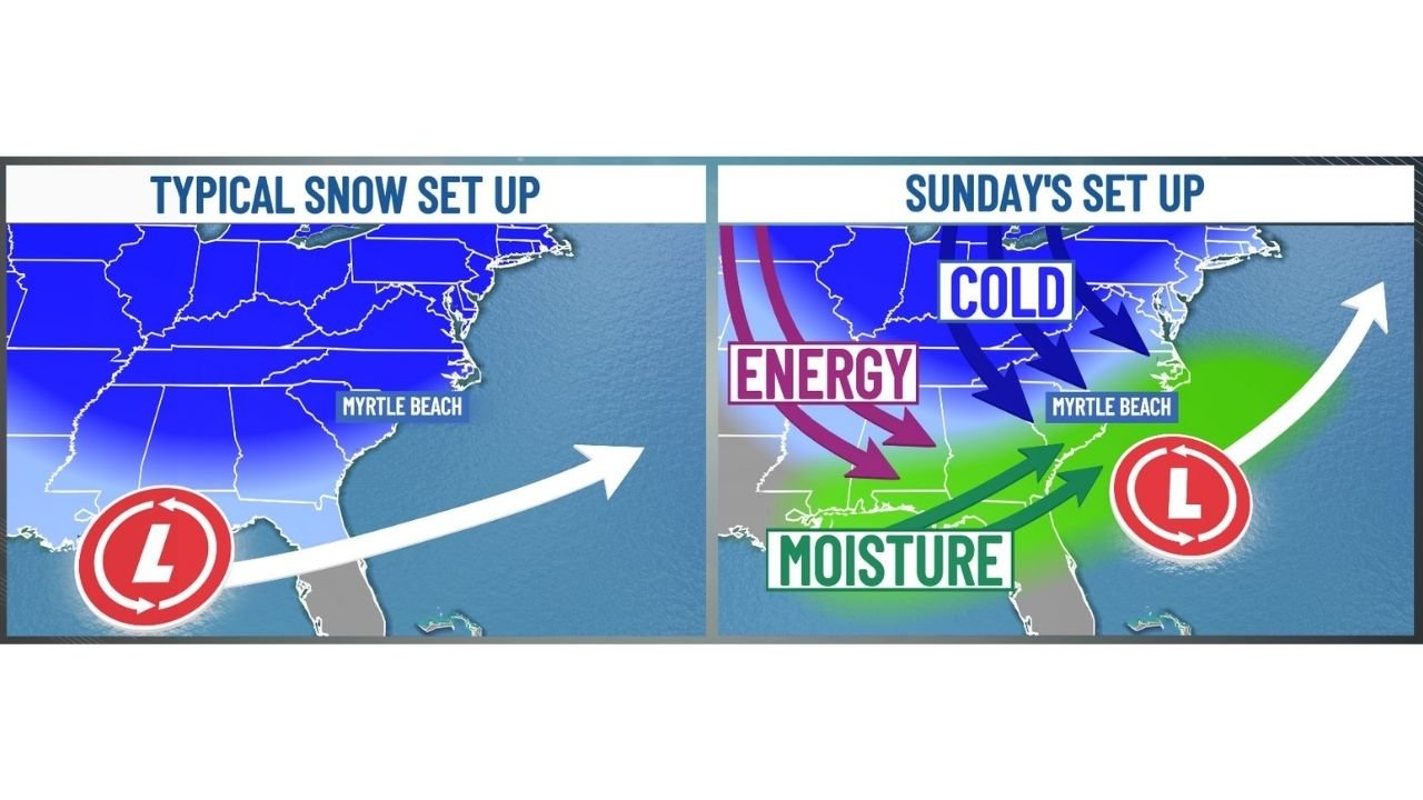
Meteorologists note that this system is not a simple slam-dunk snow setup. Instead, it relies on several moving parts coming together at just the right time—making the difference between cold rain, a light snowfall, or localized accumulations.
Why This System Is Different From Typical Carolina Snow Events
Unlike straightforward Arctic outbreaks where cold air is already firmly in place, Sunday’s system depends on energy diving south from Canada, moisture being pulled north from the Gulf of Mexico, and low pressure developing offshore.
As cold air rushes into the Carolinas, it will attempt to undercut incoming moisture. The challenge is timing:
- If cold air arrives too late, precipitation stays rain.
- If cold air arrives early enough, snow becomes possible—especially inland.
- Small shifts in storm track or speed could significantly change outcomes.
This makes Sunday’s forecast far more sensitive than last January’s winter events.
What the Models Are Showing Right Now
The European (EURO) ensemble guidance currently shows a 20–30% chance of at least one inch of snow somewhere across the Carolinas. While that probability is not high enough to signal a major winter storm, it is notable for this region, especially several days out.
Current ensemble probabilities suggest:
- Lower chances near the immediate coast, where warmer air is harder to dislodge
- Higher chances inland, where cold air can establish itself more efficiently
- Accumulations, if they occur, would likely be highly localized
Importantly, forecasters stress that model spread remains large, meaning confidence in placement and totals is still limited.
Potential Impact Areas in South and North Carolina
If snow does develop, the most favored areas would likely be:
- Inland portions of eastern South Carolina
- Parts of southeastern and central North Carolina
- Areas north and west of the coast, where cold air can deepen faster
Coastal locations, including beach communities, may see mixed precipitation or cold rain, though brief snowflakes cannot be ruled out if dynamic cooling occurs.
Why Small Changes Will Matter a Lot
This setup is extremely sensitive to:
- The strength of the Canadian cold air
- The track of offshore low pressure
- The speed at which Gulf moisture arrives
Even a shift of 50–100 miles in storm track could mean snow for one area and rain for another, which is why forecasters are urging patience as new data arrives.
What Residents Should Know Right Now
At this stage, no winter alerts are in effect, and this is not a guaranteed snow event. However, the pattern supports continued monitoring, especially for those with travel plans Sunday into early next week.
Residents should:
- Stay updated on forecast changes over the next several days
- Be prepared for colder-than-normal temperatures regardless of precipitation type
- Understand that confidence will improve as the event gets closer
The Bottom Line
Winter is not finished with the Carolinas yet. While a significant snowstorm is far from certain, the ingredients are on the table for at least a low-end snow event in parts of South Carolina and North Carolina on Sunday.
With additional model runs and updated guidance expected, forecasters emphasize this is a “buckle up and watch closely” type of setup—one where details will matter right up until the event unfolds.
Stay with Waldron News for continued updates as confidence increases and the forecast becomes clearer.