
Georgia and South Carolina Face Another Sharp Wind-Chill Drop as Teens and Lower 20s Return Friday Morning
GEORGIA — A quick-hitting surge of cold air is set to bring another round of biting wind chills late Thursday night into Friday morning, with many inland locations expected to “feel like” the teens to lower 20s. New guidance shared by the National Weather Service office in Charleston shows the highest odds of sub-20°F wind chills inland, while coastal areas still face a meaningful risk of uncomfortable, cold-start conditions for the Friday commute.
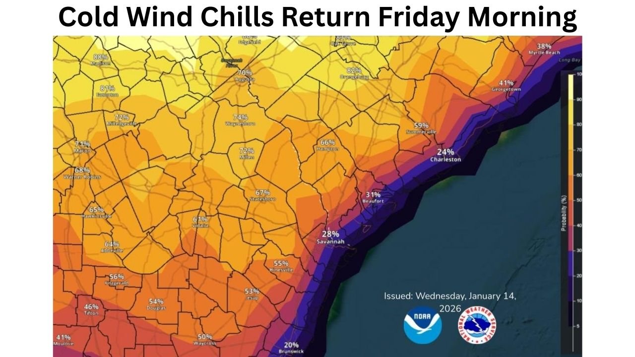
What the latest guidance shows for GA and SC
Forecast messaging from NWS Charleston points to wind chills dropping into the teens to lower 20s across parts of coastal Georgia and the South Carolina Lowcountry early Friday. The guidance also notes that the chance of wind chills falling to 20°F or lower ranges roughly 60–70% inland, with 20–50% chances closer to the coast.
On the probability map, several inland zones show the strongest signal for the coldest “feels-like” temperatures, while the immediate coastline trends lower—but not zero—especially around the Charleston-to-Grand Strand corridor.
When the coldest wind chills are expected
The time window is straightforward: late Thursday night through Friday morning. That’s when temperatures are lowest and winds can still be active enough to push apparent temperatures down several degrees—often making the morning feel significantly colder than the thermometer suggests.
Where the highest risk for sub-20°F wind chills appears
The highest probabilities are depicted inland across portions of Georgia and South Carolina, while the coastal strip shows lower—but still notable—odds.
Some of the highlighted probabilities on the map include:
- Savannah, GA area: around 28%
- Beaufort, SC area: around 31%
- Charleston, SC area: around 24%
- Georgetown, SC area: around 41%
- Myrtle Beach, SC area: around 38%
- Brunswick, GA area: around 20%
Even where probabilities are lower along the coast, a cold wind off the water can still make conditions feel harsh—especially for anyone outside for long periods early Friday.
Why this matters: commute, school mornings, and outdoor exposure
Wind chills in the teens and lower 20s can create problems fast—especially for people waiting at bus stops, working outdoors, or making early-morning commutes. The NWS also flagged that a Cold Weather Advisory may be needed for a portion of the area, depending on how the forecast firms up.
What to do now: simple steps that make a difference
If you’re in Georgia or South Carolina and heading into the Friday morning cold, a few basic moves can reduce risk and hassle:
- Dress in layers (base layer + insulating layer + outer layer that blocks wind)
- Cover exposed skin (hat and gloves matter more than people think)
- Check on neighbors, especially seniors and anyone without reliable heat
- Bring pets inside or ensure warm, dry shelter and unfrozen water
- Protect pipes (drip faucets where appropriate, open cabinet doors under sinks on exterior walls, and know where your shutoff valve is)
- Test heating sources early so you’re not troubleshooting at midnight
Bottom line for Georgia and South Carolina
A cold, uncomfortable start is likely Friday morning across parts of Georgia and South Carolina, with the strongest odds for sub-20°F wind chills inland and a continued risk of sharp wind chill near the coast. Keep an eye out for any advisories or local updates as the timing and wind strength become clearer.
If you’re in the affected areas, what are you seeing in your neighborhood—already feeling the colder air returning? Share what you’re noticing and follow the latest local updates at Waldron News.