
Alabama, Georgia, South Carolina, Louisiana, Mississippi, and North Carolina Brace for Bitter Cold, Wind Chills, and Uncertain Weekend Snow Chances
ALABAMA — A sharp blast of winter air is driving dangerous wind chills into parts of the Southeast late Thursday night into Friday morning, while forecasters also keep a close eye on a few “low-confidence” snow setups stretching from southeast Louisiana and southern Mississippi to the Carolinas this weekend.
The biggest takeaway from the latest graphics and model discussions: it will be very cold, and while snow talk is ramping up on social media, most guidance still supports only a low-end snow risk in the Deep South—with the best chance for impacts coming down to exact storm track and timing.
Cold Wind Chills Return Friday Morning in Georgia and South Carolina
A briefing graphic attributed to NWS Charleston highlights the return of cold wind chills late Thursday night into Friday morning, with wind chills expected to drop into the teens to lower 20s across parts of the region.
The advisory-style probabilities shown on the map indicate:
- Inland areas: Roughly a 60–70% chance of wind chills dropping to 20°F or lower
- Coastal areas: Roughly a 20–50% chance of wind chills dropping to 20°F or lower
In practical terms, that’s the kind of cold that can turn a normal early-morning commute into a quick frostbite risk if you’re outside too long without gloves and layered clothing—especially where winds stay up overnight.
What To Do Before the Coldest Hours Hit
With the coldest conditions focused overnight into Friday morning, the simplest steps are also the most important:
- Dress in layers and cover exposed skin if you’ll be outside early
- Bring pets indoors or ensure warm shelter and unfrozen water
- Protect pipes in vulnerable areas (especially exposed outdoor spigots)
- Check neighbors who may need help staying warm
Low Chance of Snow Saturday Night in Southeast Louisiana and Southern Mississippi
Another graphic shows a low probability (around 10–30%) of snowfall Saturday night across southeast Louisiana and southern Mississippi—but it also stresses that it may not take much to create localized impacts in this part of the Gulf South, where roads and infrastructure are less prepared for winter weather.
On the probability map for “Saturday Night Snowfall,” several city callouts fall in that low-but-not-zero range, including:
- New Orleans, LA: about 23%
- Baton Rouge, LA: about 21%
- Houma, LA: about 20%
- Lafayette, LA: about 18%
- Gulfport, MS: about 25%
- Wiggins, MS: about 31%
- Carriere, MS: about 33%
- Hattiesburg, MS: about 38%
Even with probabilities still modest, this is the type of setup where a small shift in the storm’s track can mean the difference between cold rain, brief flurries, or a short-lived burst of wet snow.
Alabama Snow “Model Buzz” Grows, But Confidence Is Still Low
One of the strongest social-media triggers right now is a model scenario suggesting a chance of more meaningful snow for the southern two-thirds of Alabama this weekend, tied to a frontal wave near the northern Gulf.
But the accompanying commentary is blunt: the American GFS is the driver of that snowy solution, and the forecaster notes that GFS has a poor track record in these types of cold-season events at this latitude.
In contrast:
- The European model (ECMWF) is described as showing nothing more than sprinkles or flurries
- The Canadian model (GEM) is described as showing nothing at all
The bottom line from that discussion: the snowier GFS idea is “rejected” for now, with the expectation that trends will be watched closely in case the broader guidance shifts.
The Carolinas Could See a Different Kind of Winter Setup Sunday
While the Gulf Coast watches Saturday night, another set of graphics focuses on the Carolinas on Sunday, emphasizing that this system would be a different setup than a classic Gulf “slam dunk.”
The explanation highlights several moving parts that must line up:
- Energy diving south out of Canada
- Moisture being pulled north from the Gulf
- Low pressure developing offshore
- Cold air rushing in at the same time
In that scenario, small differences in timing and storm placement can decide who sees rain versus sleet versus snow.
A European-ensemble snowfall probability chart specifically shows a 20–30% general chance of at least 1 inch of snow, with example probabilities including:
- Myrtle Beach, South Carolina: 16%
- Florence, South Carolina: 26%
- Lumberton, North Carolina: 32%
That doesn’t guarantee accumulating snow—especially near the immediate coast—but it does signal a setup worth monitoring for the coastal plain into portions of eastern North Carolina and South Carolina.
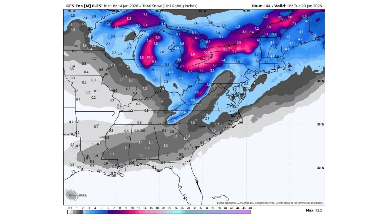
Looking Ahead: A “Bullish” GFS Ensemble Signal for a Bigger Snow Swath (But It’s Not a Lock)
A longer-range snowfall map from 18z GFS ensemble guidance shows a “bullish” stripe of heavier snow potential across parts of the Great Lakes and into the interior Northeast around Tuesday, January 20.
However, the note attached to that map cautions against overreacting: ensembles often follow the operational model’s lead, and without stronger agreement from other guidance, it’s best treated as something to watch, not something to bank on.
What This Means Right Now
Across the Southeast, the most reliable part of this forecast is the cold:
- Friday morning wind chills look like the first real, high-confidence impact for parts of Georgia and South Carolina
- Snow chances this weekend exist in pockets—from Louisiana/Mississippi to Alabama to the Carolinas—but the current signal is still low-confidence and highly track-dependent
If you live in one of the highlighted areas, the smart approach is to prepare for the cold immediately and keep checking updates as newer model runs narrow down where the best chance of wintry precipitation actually sets up.
If you’re in the Southeast, what are you seeing where you live—already preparing for the cold, or watching the snow talk closely? Share what you’re noticing and follow more weather updates at Waldron News.