
Indiana and Michigan Slammed by Lake-Effect Snow as South Bend and Notre Dame Top 16 Inches in 24 Hours
MICHIGAN — A powerful lake-effect snow event dumped heavy snowfall across northern Indiana and southern Michigan over the past 24 hours, with some communities seeing widespread accumulations of 4 to 6 inches, while the hardest-hit areas were buried under more than 16 inches of snow.
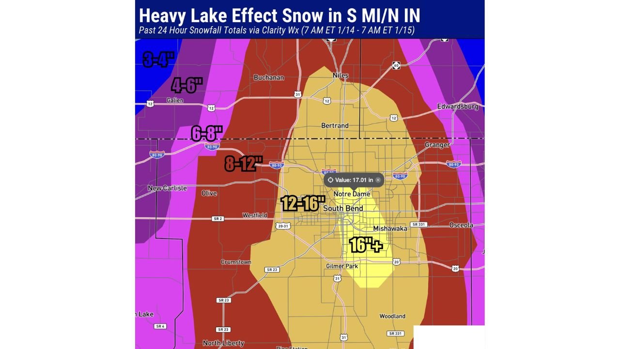
The most extreme totals were recorded in South Bend, Indiana, and on the Notre Dame campus, where persistent lake-effect snow bands parked over the region, producing intense snowfall rates for hours at a time. The event highlights how sharply snowfall can vary during lake-effect setups, with dramatic differences over just a few miles.
Snowfall Totals Show Sharp Lake-Effect Gradient
According to snowfall analysis from the past 24 hours, totals stretched from Saint Joseph, Michigan, southward into north-central Indiana, including Marion County, Indiana.
Observed snowfall amounts included:
- 4 to 6 inches across much of southern Michigan into northern Indiana
- 6 to 8 inches near the primary lake-effect band corridor
- 8 to 12 inches west and southwest of South Bend
- 12 to 16 inches across South Bend and surrounding neighborhoods
- 16 inches or more reported in localized pockets near Notre Dame
This sharp gradient is a classic lake-effect signature, driven by wind direction, band placement, and the long fetch of cold air moving across Lake Michigan.
Why South Bend and Notre Dame Were Hit Hardest
The heaviest snow fell where the lake-effect band remained nearly stationary for several hours. Cold Arctic air flowing over the relatively warmer waters of Lake Michigan created intense convection, producing narrow but extremely productive snow bands.
Key factors contributing to the extreme totals included:
- Persistent wind alignment, locking the snow band in place
- Deep moisture over the lake, fueling heavy snowfall
- Cold surface temperatures, allowing snow to accumulate efficiently
- Minimal band movement, leading to repeated heavy bursts
Once the band settled over South Bend and the Notre Dame area, snowfall rates were high enough to overwhelm plowing operations and quickly blanket roads, sidewalks, and campuses.
Travel and Visibility Impacts
Residents reported snow-covered roads, reduced visibility, and difficult travel conditions, particularly during the heaviest snowfall periods. Even nearby areas saw drastically different conditions, with lighter snow just outside the main band.
Hazards included:
- Rapidly deteriorating road conditions
- Snow-packed highways and local roads
- Blowing snow reducing visibility
- Delayed cleanup due to continued snow showers
Lake-effect snow events are especially dangerous because conditions can change suddenly as bands shift.
What Happens Next
As winds gradually shift, the most intense lake-effect band is expected to weaken or move away, though additional snow showers remain possible in traditional lake-effect zones. Cleanup efforts will continue across northern Indiana and southern Michigan as crews work to clear roads and sidewalks.
Residents are urged to remain cautious, as residual blowing snow and icy conditions can persist even after snowfall ends.
Bottom Line
A high-impact lake-effect snowstorm delivered widespread snowfall across Indiana and Michigan, with South Bend and Notre Dame emerging as the hardest-hit areas, recording over 16 inches of snow in just 24 hours. The event underscores the power and unpredictability of lake-effect snow along Lake Michigan.
Did you experience this lake-effect snow where you live, or were conditions dramatically different just a few miles away? Share your experience and stay connected with ongoing winter weather coverage from Waldron News.