
Louisiana, Arkansas, Mississippi, Alabama, Georgia and Florida Could See Rare Snow Flurries as Southeast Watches January 17–18 System
FLORIDA — A rare winter setup is taking shape across the Deep South and Southeast, where forecasters are monitoring a system that could bring snow flurries and even light accumulation to parts of Louisiana, Arkansas, Mississippi, Alabama, Georgia, Florida, and the Carolinas late Saturday night into early Sunday, January 17–18.
While confidence remains moderate at best, early guidance suggests cold air will be in place as a weak low-pressure system moves along the Gulf Coast and then tracks just offshore of the Southeast. If moisture and timing align, portions of the region could see their first snowflakes of the season — an unusual sight for mid-January this far south.
Where Snow Flurries Are Most Likely
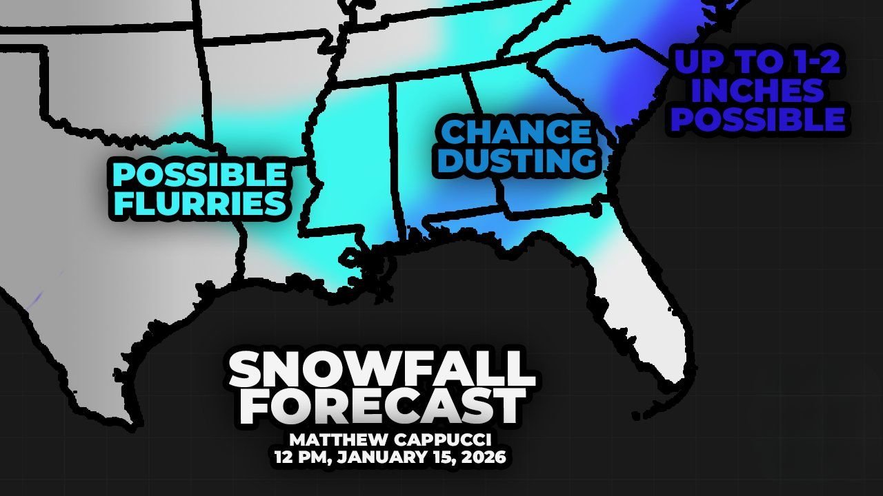
Current projections indicate the best chance for flurries stretches across a broad zone of the Deep South, including:
- Central and northern Louisiana
- Southern Arkansas
- Much of Mississippi
- Northern and central Alabama
- Large portions of Georgia
- Northern Florida, including the Panhandle
In these areas, snow would most likely fall as brief flurries or very light snow, with little to no accumulation for most locations.
Dusting Possible in Select Southern Areas
Forecasters note that a light dusting of snow cannot be ruled out if conditions come together just right, especially in:
- Southern Mississippi, including areas near Biloxi and Gulfport
- Coastal Alabama, including Gulf Shores
- Parts of the Florida Panhandle
- Interior sections of Georgia, potentially including Macon and even the Atlanta metro
Ground temperatures will play a major role, and any accumulation would likely be short-lived, favoring grassy or elevated surfaces.
Carolinas Have the Best Chance for Measurable Snow
If any region sees 1 to 2 inches of snow, forecasters believe it would most likely occur in the coastal Carolinas. These areas are expected to be closest to the developing low-pressure system, allowing for slightly better moisture availability compared to locations farther west.
This offshore track increases the potential for:
- Light accumulating snow
- Brief bursts of moderate snowfall
- Localized slick spots, especially early Sunday morning
Even here, totals remain uncertain and highly dependent on the storm’s final path.
Why This Setup Is Tricky
This forecast comes with notable uncertainty due to:
- Marginal temperatures, especially near the coast
- Moisture availability, which may be limited inland
- Storm track sensitivity, where small shifts can dramatically change outcomes
- Timing, with overnight cooling playing a key role
As a result, forecasters stress that snowfall maps will likely change as the weekend approaches.
What to Expect Next
Forecast updates over the next several days will focus on:
- Refining the rain vs. snow line
- Pinpointing where dusting potential increases
- Identifying whether coastal snow chances grow
- Determining any travel impacts, even minor ones
Residents across the Deep South and Southeast are encouraged to stay weather-aware, especially in regions that rarely see winter precipitation.
Bottom Line
A potential winter weather event could bring snow flurries and isolated light accumulation to parts of Louisiana, Arkansas, Mississippi, Alabama, Georgia, Florida, and the Carolinas this weekend. While widespread snow is not expected, the setup is unusual enough to warrant close monitoring as forecast details continue to evolve.
Do you think your area will see snowflakes this weekend, or will this system stay just cold and dry? Share your thoughts and keep following Waldron News for the latest Southeast winter weather updates.