
North Dakota and Minnesota Brace for Arctic Front as Blowing Snow and Reduced Visibility Threaten Friday Morning Commute
NORTH DAKOTA — A sharp arctic front is expected to surge southward after midnight, bringing a period of snow showers, strong north–northwest winds, and blowing snow across much of eastern North Dakota and northwestern Minnesota. While snowfall totals are expected to remain relatively light, forecasters warn that visibility reductions and hazardous travel conditions could significantly impact the Friday morning commute.
According to the latest outlook from the National Weather Service in Grand Forks, snow amounts will generally range from one-half inch to 2 inches, but gusty winds behind the front will be the primary concern, creating areas of blowing and drifting snow, especially in open and rural locations.
What to Expect as the Arctic Front Moves Through
The front is forecast to pass through the region late tonight, with conditions deteriorating quickly behind it. Snow showers will develop as colder air pours in, accompanied by strong NNW winds that persist overnight into Friday midday.
Key forecast details include:
- Snowfall totals: Generally 0.5 to 2 inches
- Timing: Late tonight through Friday morning, tapering by midday
- Winds: Strong north winds with gusts over 40–50 mph in spots
- Primary hazard: Blowing snow and sharply reduced visibility
Even modest snowfall can become dangerous under these conditions, as loose snow is easily lofted by strong winds.
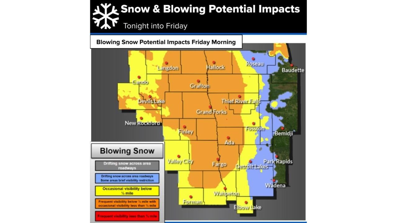
Blowing Snow Could Severely Limit Visibility
Forecast maps highlight a wide swath of blowing snow potential impacts Friday morning, particularly across eastern North Dakota, including areas near Grand Forks, Fargo, Devils Lake, and Valley City, and extending into parts of northwestern Minnesota, including Detroit Lakes and surrounding communities.
In the hardest-hit areas, visibility could:
- Drop below one mile at times
- Fall under one-half mile in open, unsheltered areas
- Change rapidly from clear to near whiteout over short distances
These conditions are especially dangerous for early-morning travelers and commercial traffic.
Friday Morning Commute at Risk
The combination of snow showers, strong winds, and blowing snow is expected to coincide with the Friday morning commute, increasing the risk of accidents and delays.
Travel concerns include:
- Snow-covered and drifting roads
- Sudden visibility drops
- Difficult driving on east–west roads
- Higher risk in rural and open areas
Motorists are urged to allow extra travel time and remain alert for rapidly changing conditions.
Cold Air Settles In Behind the Front
Behind the arctic front, colder air will firmly settle across the region, keeping snowpack loose and prone to blowing even after snowfall ends. Winds are expected to gradually ease later Friday, but lingering impacts may persist into the afternoon.
Residents should prepare for wind chills and continued winter travel challenges through the end of the workweek.
Bottom Line
A fast-moving arctic front will bring snow showers, strong winds, and blowing snow to North Dakota and Minnesota late tonight into Friday, with light snowfall amounts but potentially dangerous travel conditions, especially during the Friday morning commute. Reduced visibility will be the main hazard, not total snow accumulation.
Will blowing snow affect your Friday travel plans, or are conditions already worsening where you live? Share your local observations and stay informed with the latest regional winter weather updates from Waldron News.