
Michigan Braces for Widespread Snow as Lake-Effect Bands Bring 2–5 Inches Inland and 4–7 Inches Along the Lakeshore Into Saturday
MICHIGAN — A period of widespread snowfall is expected across western and central Michigan from Friday into Saturday morning, with the heaviest snow rates arriving Friday morning and Friday afternoon, a timing that is likely to disrupt both the morning and evening commutes. Forecasters say a classic lake-effect setup off Lake Michigan will focus the highest totals near the lakeshore, while steady accumulations spread inland.
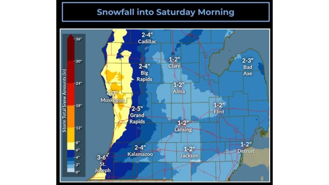
According to the National Weather Service in Grand Rapids, snowfall totals will generally range from 2 to 5 inches along the US-131 corridor, while 4 to 7 inches are expected closer to the Lake Michigan shoreline, with isolated higher totals possible in the most persistent snow bands.
Heaviest Snow Targets the Lakeshore and US-131 Corridor
Forecast guidance shows lake-enhanced snow bands developing and repeatedly moving onshore, producing periods of moderate to heavy snow, especially from Muskegon and Holland northward toward Grand Haven and beyond.
Expected snowfall ranges include:
- US-131 corridor (including Grand Rapids): 2 to 5 inches
- Immediate lakeshore: 4 to 7 inches
- Isolated lakeshore locations: 8 inches or more possible, especially north of Holland
- Farther inland (Lansing, Jackson, Flint): Generally 1 to 2 inches
Snow amounts will vary sharply over short distances, a hallmark of lake-effect events.
Timing: Commutes Likely to Be Impacted
The most impactful snow is expected Friday morning through Friday afternoon, when snowfall rates may be high enough to quickly coat roads and reduce visibility.
Key timing details include:
- Friday morning: Snow intensifies, affecting the morning commute
- Friday afternoon: Heaviest snowfall rates, continued travel impacts
- Friday night into early Saturday: Snow tapers but continues in lake-effect bands
- Saturday morning: Lingering snow showers, slick roads possible
Even after snowfall rates decrease, blowing snow could keep travel hazardous.
Wind Adds to Travel Concerns
Westerly winds of 15 to 25 mph are expected, which will contribute to:
- Reduced visibility in heavier snow
- Blowing and drifting snow, especially in open areas
- Rapidly changing road conditions, particularly near the lakeshore
These conditions can cause drivers to encounter clear roads one moment and snow-covered lanes the next.
Why This Event Is Focused Near Lake Michigan
Cold air moving across the relatively warmer waters of Lake Michigan is fueling the snow bands. As winds align favorably, snow showers become more organized and efficient, leading to higher totals near the shoreline and decreasing amounts farther inland.
Small shifts in wind direction could still alter where the heaviest bands set up, which is why localized totals may end up higher than currently forecast.
What Drivers Should Expect
Residents and travelers across western Michigan should prepare for:
- Slick, snow-covered roads
- Slower commute times
- Reduced visibility during heavier snow
- Localized travel disruptions, especially near the lakeshore and US-131
Officials recommend allowing extra time for travel and using caution, particularly during peak commute hours.
Bottom Line
A lake-effect snow event will impact much of western and central Michigan through Saturday morning, bringing 2 to 5 inches along the US-131 corridor and 4 to 7 inches along the Lake Michigan shoreline, with isolated totals over 8 inches possible. The Friday morning and evening commutes are most likely to be affected as snow falls steadily and winds reduce visibility.
How much snow are you seeing where you live, and are roads already becoming slick? Share your local conditions and stay with Waldron News for continuing updates as this Michigan snow event unfolds.