
Alabama, Mississippi, Georgia, and Florida Panhandle Face Uncertain Wintry Weather Threat Late Saturday as Gulf System Develops
DEEP SOUTH — Forecasters are closely monitoring a potential wintry weather setup for late Saturday night into early Sunday across parts of Alabama, Mississippi, Georgia, and the Florida Panhandle, though uncertainty remains high regarding snowfall amounts and exact placement. While significant snow is not guaranteed, weather officials stress that conditions could come together just enough to produce wintry precipitation in some areas, making preparation important.
The latest guidance shows a cold front pushing south Saturday night, followed by the development of low pressure over the Gulf of Mexico. If that system strengthens and tracks favorably, it could pull enough moisture northward to interact with colder air, resulting in a brief window of wintry precipitation late Saturday night into early Sunday morning.
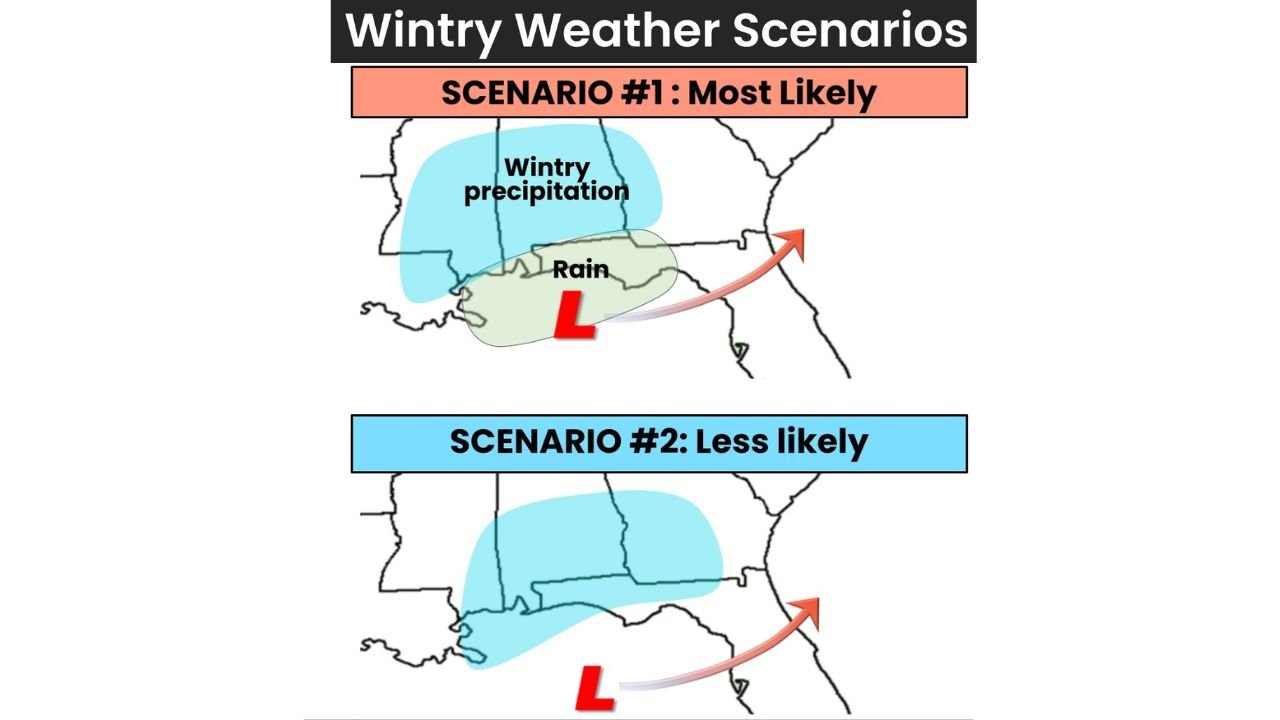
What Forecasters Say Is Most Likely Right Now
According to the National Weather Service, the most likely scenario features:
- Rain for many areas initially, especially closer to the Gulf Coast
- Colder air filtering in Saturday night
- A narrow zone of wintry precipitation developing north of the rain shield
- Low overall odds of significant accumulation
At this time, forecasters estimate only a 10–30% chance of snowfall exceeding 1 inch in any one location. Still, even light wintry precipitation can create slick roads and travel issues, especially overnight.
Areas Most at Risk If Conditions Align
If the system evolves in a more favorable way, light snow or a wintry mix could affect:
- Interior Mississippi
- Central and northern Alabama
- Parts of central Georgia
- Portions of the Florida Panhandle
Coastal areas are more likely to remain rain-dominated, but just inland locations could see brief snow or sleet, particularly late Saturday night.
Alternate Scenario: Less Likely but Still Possible
A second, less likely scenario keeps the storm system farther south and weaker. In this case:
- Rain remains the dominant precipitation type
- Wintry precipitation is limited or does not materialize
- Snow accumulations remain minimal or nonexistent
Forecasters emphasize that small shifts in storm track or temperature profiles will determine which scenario unfolds.
What Remains Uncertain
Meteorologists say several key factors are still unclear:
- Exact track of the low-pressure system
- How quickly cold air moves in
- Duration of wintry precipitation
- Whether snow can accumulate at all
These details are expected to become clearer as higher-resolution models come into focus over the next 24–48 hours.
What Residents Should Do Now
Even with uncertainty, officials recommend taking basic preparedness steps:
- Review safety and emergency plans
- Monitor updated forecasts frequently
- Rely on trusted weather sources
- Consider alternate plans for late Saturday night travel
Those traveling overnight or early Sunday morning should remain alert for isolated slick spots, especially on bridges and elevated roadways.
Bottom Line
A low-confidence but noteworthy wintry weather threat exists for parts of Alabama, Mississippi, Georgia, and the Florida Panhandle late Saturday night into early Sunday. While widespread snowfall is not expected, even a brief period of wintry precipitation could impact travel. Forecasts will continue to be refined as the weekend approaches.
Are you adjusting your weekend plans because of this potential weather setup? Share your thoughts and stay with Waldron News for the latest updates as forecasters fine-tune the weekend forecast.